Last year alone, natural disasters struck over 430 times around the globe, wreaking havoc on communities and their livelihoods. In total, these events affected 101.8 million people. More than 10,000 people lost their lives, while the economic damage surpassed $250 billion. Countries globally must become better prepared to deal with these situations by employing the newest solutions, including those enabled by space assets.
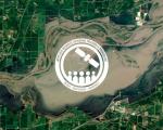
Regional Workshop on Assessing Drought Risks and Launch SADMS
The event was organised by the SAARC Disaster Management Centre with support from the UN-SPIDER programme of the UN Office for Outer Space Affairs and International Water Management Institute (IWMI), one of the 26 regional support offices of UN-SPIDER, and the Indian Council of Agricultural Research. The workshop was attended by over 25 participants from Bangladesh, India, Maldives, Nepal, Pakistan and Sri Lanka.
The Earth Science Applications Guidebook, created by the NASA Applied Science program, is a collection of best practices and lessons learned on the use of Earth science information for decision-making. Available as web-based multimedia product, it showcases the wealth of knowledge and the passion of scientists, addressing climate change, biodiversity, disaster management, and other challenges.
This is event is available for participation on an ongoing basis
A three day virtual celebration of the many ways NASA Earth Science is being utilized to make our world a better place.
Organized by the NASA Earth Applied Sciences Program, Earth Science Applications Week highlights experts and end users from within and outside the agency, speaking about everything from space-borne to boots on the ground solutions to our planet's most pressing concerns.
The United Nations Office for Outer Space Affairs (UNOOSA) and the Government of Japan in cooperation with the Kyushu Institute of Technology (Kyutech) are looking for students from developing countries to study nano-satellite development. Another round of the post-graduate study on Nano-Satellite Technologies (PNST) Programme, part of the Access to Space for All initiative, is now open for applications. The partners offer three slots in the Master Programme and three in the Doctoral Programme, covering the tuition fee as well as a stipend to cover living expenses.
This is event is available for participation on an ongoing basis
The EU Space Week 2022 is bringing together the entire EU Space community under one roof in Prague. From policymakers to industry, start-ups, public authorities, investors and users, it is the place to be for anyone interested in current – and future – trends of the EU Space Programme.
Local, city, state, federal, and private institutions involved in disaster management, water resources management, urban planning, dams and hydropower management.
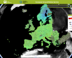
Subsidence processes, sinkholes, or landslides can cause many problems. Even minor subsidence can weaken buildings and infrastructure and lead to issues such as flooding, and in worst cases abrupt disappearance of sections of land. Monitoring and predicting such processes are essential for adopting mitigating strategies.
The new European Ground Motion Service, created and offered by the Copernicus Land Monitoring Service and implemented by the European Environment Agency, provides free and accessible ground motion data.