New UNOOSA/UN-SPIDER Publication: Space Technologies for Early Warning Systems

UN-SPIDER launched a new publication: “Space-based Technologies for Early Warning Systems” during its currently ongoing conference.

You can access the pdf version of the publication using this link.

martin.hilljegerdes Tue, 12 Mar 2024 - 10:39
OCHA Publication: The State of Open Humanitarian Data 2024

As part of their 10 year anniversary, the Centre for Humanitarian Data, under the United Nations Office for the Coordination of Humanitarian Affairs (OCHA) has released a publication reviewing the progress of its open-access data platform, the Humanitarian Data Exchange (HDX), providing insights as to the future plans and contribution needs for the platform.

spencer.zinke Fri, 1 Mar 2024 - 12:37
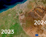
Prolonged Droughts Cause Critical Impacts in the Mediterranean and Northern Africa

For six years in Northern Africa and two years in Europe, persistent droughts have caused critical impacts such as water shortages and decreased vegetation growth. In the midst of winter, the ongoing drought is already having critical impacts, according to the report compiled by the JRC-run European Drought Observatory (EDO). Above-average temperatures, minimal precipitation, and warm spells affect the Mediterranean regions.

josi.bregulla Mon, 26 Feb 2024 - 15:34
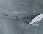
Tracking Oil Spill in Trinidad and Tobago Using Sentinel-1 Imagery

On the 7th of February 2024, a vessel in proximity to Tobago’s southern coastline was found to be capsized and leaking oil into the sea. While local authorities continue to deal with the ongoing issue, satellite imagery shows how this oil spill is progressing. Using satellite radar imagery gathered from the Copernicus Sentinel-1 mission and processed by the ESA, we can see how far the oil spill has traveled thus far. As of the 14th of February, the imagery shows that the oil spill has spread for more than 160 km westward, and may affect neighboring Grenada and Venezuela.

spencer.zinke Mon, 26 Feb 2024 - 15:19

Indian Space Research Organisation Launches Meteorological Satellite INSAT-3DS

On Saturday, 17 February 2024, the Indian Space Research Organisation (ISRO) successfully launched a meteorological satellite into Geostationary Orbit. This satellite is designed to provide support, including disaster warnings, among other functions.

The INSAT-3DS satellite is a component of the GSLV-F14/INSAT-3DS mission and is funded by the Ministry of Earth Sciences (MoES). The mission aims to achieve enhanced meteorological observations and improve monitoring of land and ocean surfaces.

NASA ROSES-2024: New NASA Disasters Funded Research Opportunities

The NASA Disasters program seeks proposals for projects that expand the development and application of tools and capacities in the use of Earth science information for supporting decisions related to disaster risk reduction, recovery, or resilience. Proposals are required to address the linkages between natural or human-made hazards, exposure to these hazards, and the vulnerability of communities to these hazards for improved disaster management.

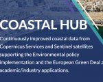
Copernicus Newly Launched Coastal Hub

The coastlines of the world host a rich mix of dense populations, varying industries, and environmental characteristics that are collectively influenced by both land and sea. To facilitate the production of knowledge and data products regarding these complex coastal regions, the European Commission under the Copernicus program has developed a new online resource: The Copernicus Coastal Hub. The Coastal Hub offers a singular resource for data related to coastal regions including examples of use cases and an interactive data and map viewer.

spencer.zinke Fri, 23 Feb 2024 - 14:59

UN-SPIDER/ECLAC/International Charter Training Course for Latin America

This is event is available for participation on an ongoing basis

As in the case of other regions of the world, Latin America is exposed to various types of geological and hydro-meteorological hazards which trigger disasters.  To contribute to strengthen the skills of professionals that contribute to disaster response efforts through the generation of space-based information, UN-SPIDER, ECLAC and the International Charter Space and Major Disasters organised the training course "Project Management using the ESA Charter Mapper".   The training course brought together 15 professionals with skills in project management in case of activ

0
0
Professionals with skills in project management in case of activations of the International Charter
No certificate issued or not known
0.00
USD
11/07/2023, 12:00am - 11/09/2023, 12:00am
not visible
Santiago de Chile

International Charter Space and Major Disasters

ECLAC

UN-SPIDER

Spanish