  • English
  • Español
  • Français

United
Nations


Office for Outer Space Affairs
UN-SPIDER Knowledge Portal

  • Home
  • About Us
    • What is UN-SPIDER?
    • About UNOOSA
    • Publications
    • Jobs
    • Meet the Team
    • Contact
  • Space Application
    • Satellite Technology
    • Emergency Mechanisms
    • Recovery Mechanisms
    • International Asteroid Warning Network
    • Space Mission Planning Advisory Group
    • International Space Weather Initiative
    • Space Technologies in the UN
    • User Stories
  • Links & Resources
    • Data Applications
      • Disaster Recovery
    • Data Sources
    • GIS and Remote Sensing Software
    • Online Learning Resources
    • Institutions
  • Risks & Disasters
    • Disaster Risk Management
    • Early Warning Systems
    • Emergency and Disaster Management
    • Natural Hazards
    • Sendai Framework
    • The UN and Disaster Risk Management
    • The UN and Early Warning
    • The UN and Disaster Management
  • Advisory Support
    • Advisory Missions
    • Emergency Support
    • Virtual Advisory Support
    • Recommended Practices
    • Training Activities
    • Practical Uses
  • Network
    • Regional Support Offices
    • GP-STAR
    • MHEWS
    • IWG-SEM
  • Projects
    • SPEAR
    • SEWS-D
    • EvIDENz
    • Flood GUIDE
  • News & Events
    • News
    • Events Calendar
    • UN-SPIDER Events Archive
  • Admin
    • SAM Items

Breadcrumb

  • Home
  • Space Application
  • Satellite Technology
  • Cartosat-2C
  • Cartosat-2C

Cartosat-2C

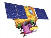
Cartosat-2 is an advanced remote sensing satellite with a single panchromatic camera (PAN) capable of providing scene-specific spot imageries for cartographic applications. The camera is designed to provide imageries with better than one meter spatial resolution and a swath of 10 km. The satellite will have high agility with capability to steer along and across the track up to + 45 degrees. It will be placed in a sun-synchronous polar orbit at an altitude of 630 km. It will have a revisit period of four days. The re-visit can be improved to one day with suitable orbit manoeuvres.

Several new technologies like two mirror on axis single camera, Carbon Fabric Reinforced Plastic based electro optic structure, lightweight, large size mirrors, JPEG like data compression, advanced solid state recorder, high-torque reaction wheels and high performance star sensors are being employed in Cartosat-2.

Beginning with Cartosat 2C, a Multi-spectral camera was added and a lower 505 km orbit for better ground reslution was introduced.

Instruments:
PAN (Panchromatic Camera)
Multispectral camera
 

22 Jun 2016
5years
Polar
Sun synchronous
95 minutes
Multispectral Imaging Spectrometer
Panchromatic Imaging Camera
ISRO
High precision large-scale cartographic mapping of 1:10000 scale and thematic applications (with merged XS data) at 1:4000 scales
Drought
Landslide
Tsunami
Earthquake
Flood
Glacial Lake Outburst
Forest Fire
Volcanic Eruption
Mass Movement
No
Information about Cartosat-2C on ISRO web page

Footer menu

  • Contact
  • Terms of Use

User account menu

  • Log in