Table of Content
- Introduction
- The Use of Space Technologies in Disaster Recovery
- Organizations Involved in Satellite-based Disaster Recovery
- References
1. Introduction
The recovery in the aftermath of a disaster involves the processes of rebuilding and restoring infrastructure and livelihoods, as well as economic, physical, social, cultural and environmental assets, systems and activities following the immediate response after a disaster. In order to reduce the risk of future disasters, the recovery process needs to be used as an opportunity to rebuild the affected areas and communities in a way that ensures a resilient and sustainable future (Ghaffrian 2021). One of the key priorities of the Sendai Framework for Disaster Risk Reduction is to improve disaster preparedness by “Building Back Better” in the recovery phase. Building back better is a holistic concept to create a more disaster resilient community in an effective and efficient way (UNDRR 2015). Following this concept, recovery efforts should aim at decreasing communities' vulnerabilities and bolstering their resilience. This involves conducting infrastructure reconstruction or rehabilitation activities in a manner that prioritizes sustainability and resilience, while also factoring in disaster risk reduction considerations (CEOS et al. 2019).
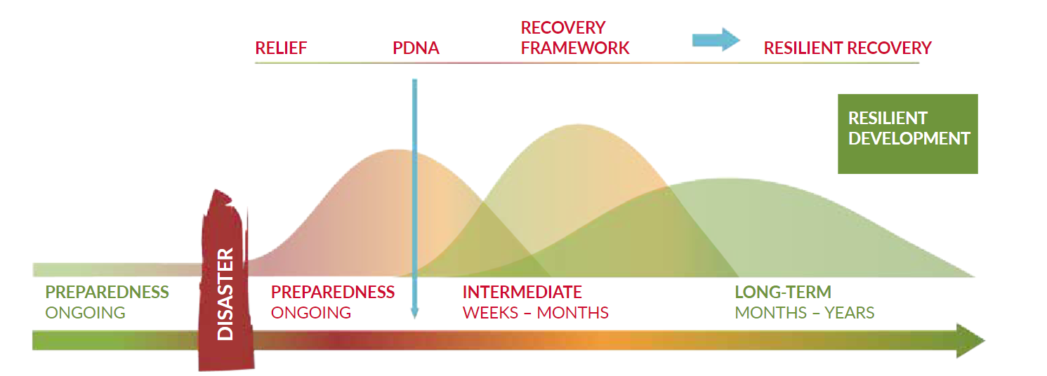
Recovery efforts are often divided into early- and long-term recovery. Early recovery covers the first 1 to 12 months after a disaster and focuses on the assessment of impacts and planning of recovery activities. Long-term recovery can take years or even decades. In this period the actual rebuilding and recovery are taking place (CEOS et al. 2019).
2. The use of space technologies in disaster recovery
Space technologies and remote sensing data and techniques are used in all phases of the Disaster Management Cycle, ranging from vulnerability analysis and risk modelling to early warning and the facilitation of relief and response operations (Krishnamoorthi 2016). However, different phases of the disaster management cycle require different approaches on using space technologies. Using satellite imagery during the response phase for example, follows different priorities and indicators and requires a fast data provision. Meanwhile during recovery efforts, the time pressure is reduced and the main focus shifts to a more in-depth analysis (Contreras et al. 2016). While some phases of the disaster management cycle are more extensively studied than others, recovery is one of the least studied phases. Consequently, only a small number of studies have been focusing on the use of remote sensing data for the recovery phase (Ghaffarian et al. 2020).
The process of planning and implementing recovery measures, tracking progress, and comprehending the various elements and their contributing factors is a multifaceted undertaking that demands dependable information to facilitate sustainable decision-making. A range of data analysis methods has been developed utilizing satellite, airborne, and Unmanned Aerial Vehicle (UAV) images (Ghaffarian et al. 2020).
Earth Observation (EO) satellites can support the recovery efforts in many ways such as by monitoring and collecting information regarding reconstruction efforts, damage assessment, population displacement or understanding the effects of different recovery scenarios and thus providing tools for decision-makers and much more (Krishnamoorthi 2016). A selection of potential use cases to support recovery efforts with space technologies is showcased below.
2.1 Damage Assessment
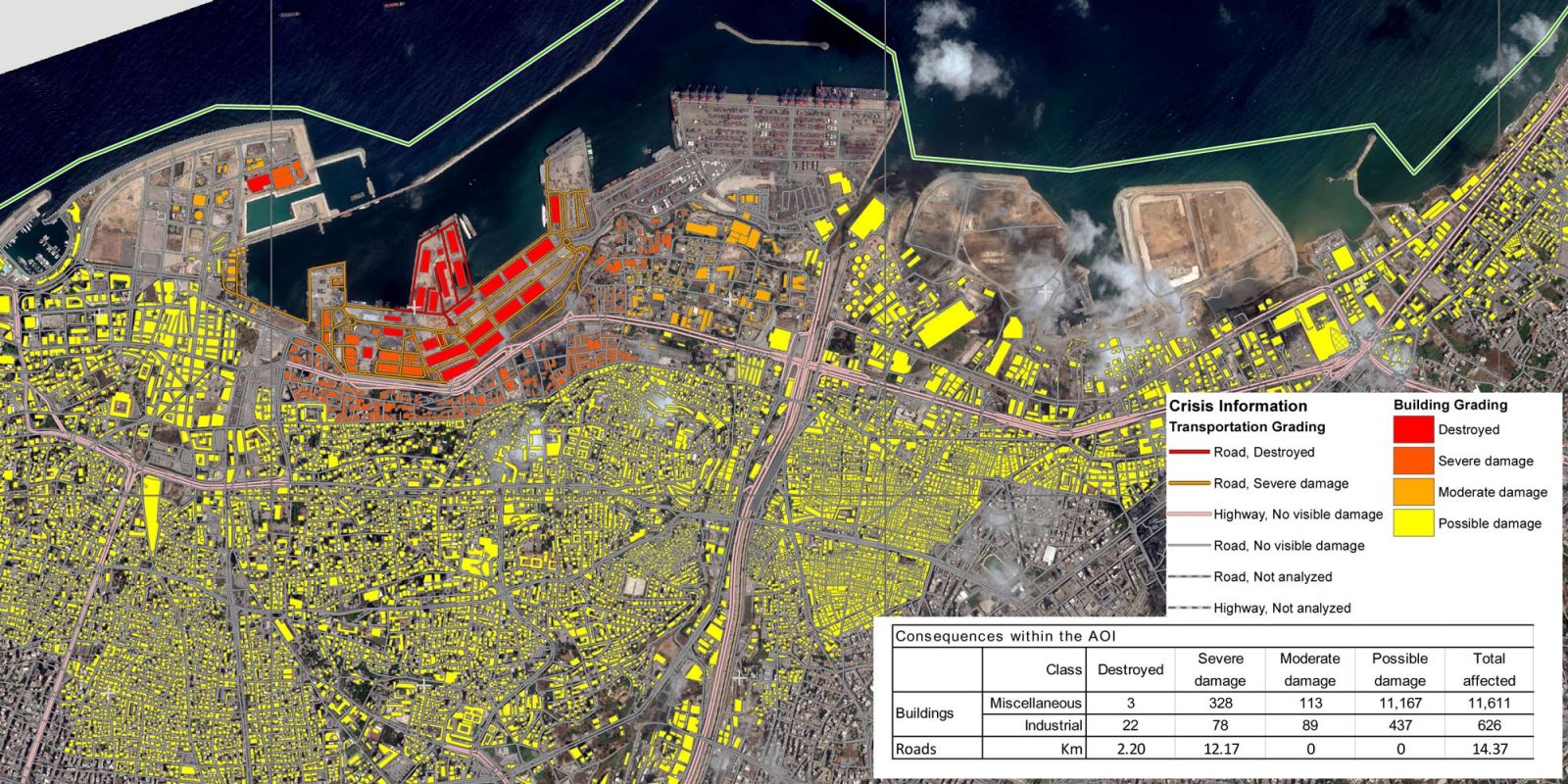
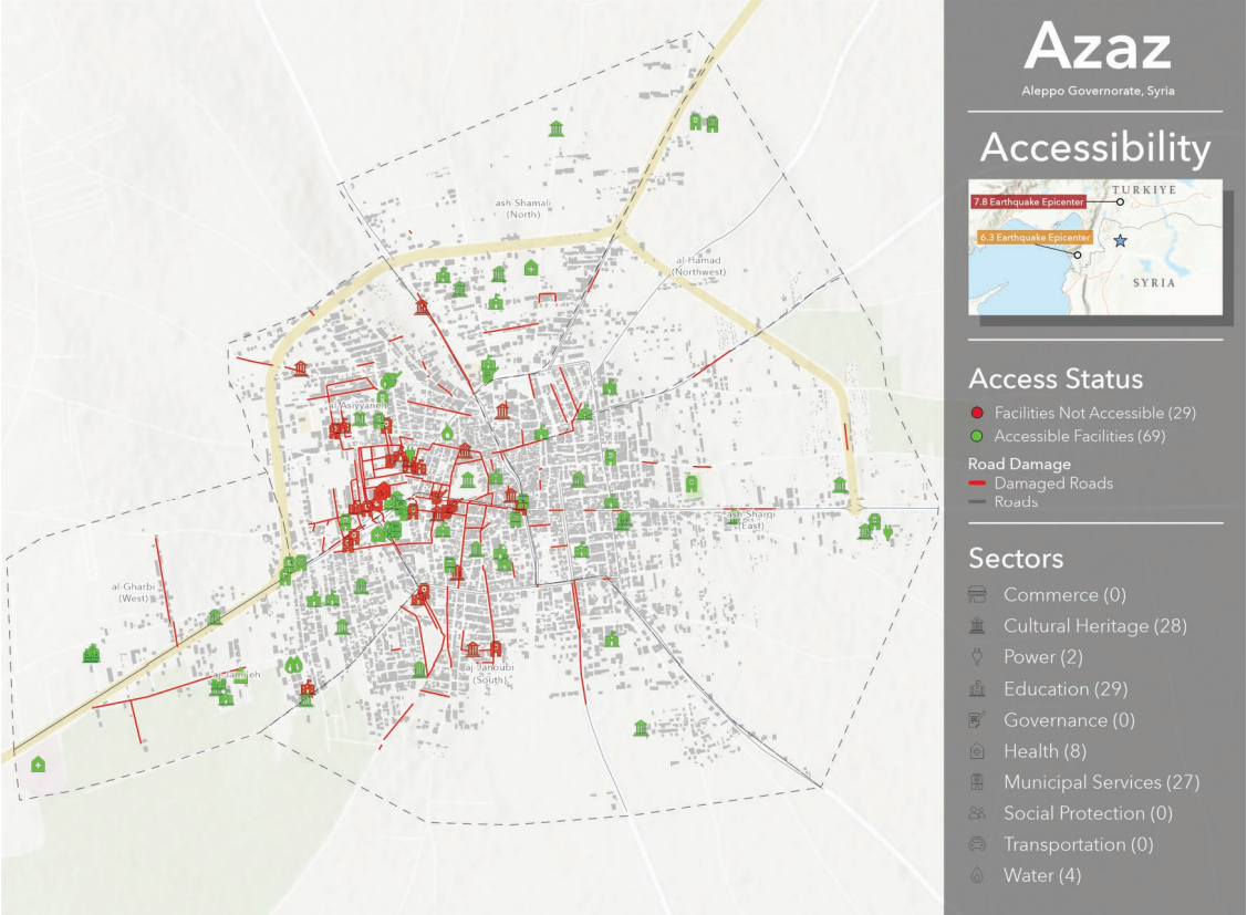
Satellite imagery has the capability to assess the extent of destruction and damage caused by disasters and to produce accurate maps of the affected regions. These maps can assist in recovery planning by identifying areas that require reconstruction or rehabilitation and thus prioritizing recovery initiatives. Moreover, satellite imagery can be utilized to pinpoint locations where infrastructure, such as roads, bridges, and buildings, needs to be reconstructed or rehabilitated. This knowledge can assist in prioritizing infrastructure redevelopment efforts and support monitoring of reconstruction activities ensuring that structures may withstand future disasters (Ghaffarian & Emtehani 2021).
UN-SPIDER together with partners developed a recommended practice on Earthquake Urban Damage Detection Using Sentinel-1 Data that provides a step-by-step guide on using a change detection method with SAR images for urban damage assessment. Apart from the use for economic calculations and needs assessment, damage assessment maps can provide valuable insights into the accessibility of key infrastructure, which plays an important role in the effectiveness of recovery efforts.
2.2 Post Disaster Needs Assessment (PDNA)
One of the applications of remote sensing and space technology in recovery is Post Disaster Needs Assessment in the aftermath of a disaster. PDNA can support policy makers and planners through the determination of physical damage and first estimates of economic losses, the rehabilitation of service provision and the costs of meeting recovery needs. Satellite data can play a key role in supporting information collection, by providing data and analyses on the recovery needs and the costs in an accessible manner (CEOS et al. 2019).
The PDNA follows a globally established and recognized damage, loss, and needs assessment methodology developed by the World Bank Group (WBG), the European Union (EU), and the United Nations (UN). This methodology has been applied globally in post-disaster and conflict contexts and has become a standardized process to assess damage and to inform recovery and reconstruction planning. It offers a structured approach for efficiently gathering and analysing data, and devising recovery plans that can be applied to various aspects of society, such as production, infrastructure, social issues, human development, finance, macroeconomic concerns, and development matters that affect multiple sectors. Based on the assessment results, short-, medium-, and long-term recovery needs of a country are evaluated. These needs then inform decision-makers on how to allocate resources that can have significant and lasting effects on people's livelihoods, human and social development, and a nation's strategic interests (CEOS et al. 2019).
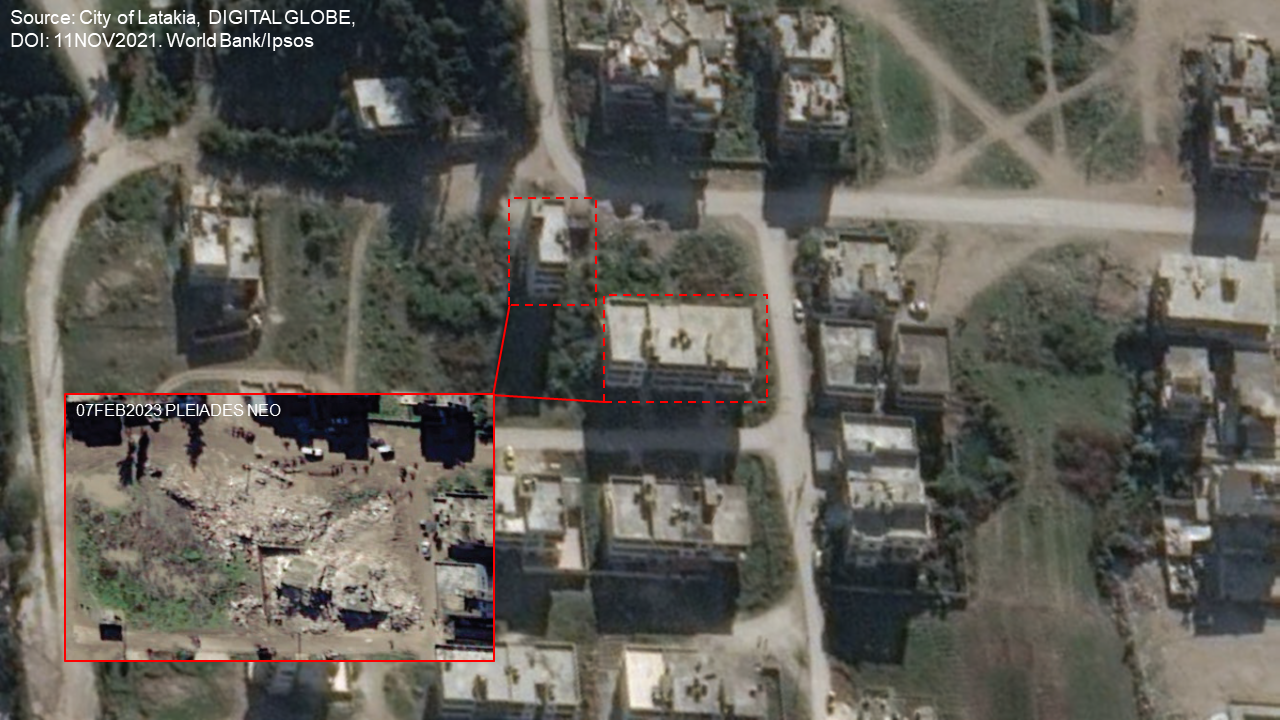
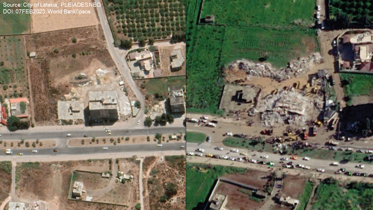
For example, a PDNA was carried out in Syria after the Türkiye-Syria Earthquake in February 2023 by the World Bank and the Global Facility for Disaster Reduction and Recovery (GFDRR), estimating the immediate early recovery needs (0-1 year) and the short-term needs (1-3 years). The assessment was based on estimations are current prices, considering inflation, security, insurance premiums and a build-back-better factor. The assessment is methodologically based on remote data sources, such as very high-resolution satellite imagery (50 cm), (social) media analytics, anonymized cell phone data and night lights data (The World bank 2023). Night lights data show a close relationship to economic activities and can thus be very valuable in urban areas (Sutton et al. 2007). In this way the impacts of the earthquake on different sectors were calculated to facilitate decision-making and prioritization of efforts. Impacts included in the analysis are macroeconomic and socioeconomic impacts, impacts on the social sector, the physical infrastructure and productive assets as well as cross-cutting sectors (The World bank 2023).
Although remote data can provide valuable information, it is still broad and impaired by data constraints and limitations and can only provide a first overview of the impact. It is always recommended to include ground observation, when feasible, to validate the remote data (The World Bank 2023).
2.3 Monitoring Recovery Efforts
Monitoring recovery efforts can provide a variety of useful information for end-users and the decision-making process. The integration of analytical and geospatial information allows the identification of recovery hotspots, areas with best rates of recovery and areas where recovery efforts are slow or stagnating (Contreras et al. 2016). This can help to ensure that recovery efforts are proceeding as planned and identify areas where additional resources might be needed.
In 2009 the city L’Aquila in Italy was severely damaged by an earthquake. In the aftermath of the event, recovery efforts were monitored by using remote sensing, ground observation and geographical information systems (GIS), as outlined in the work of Contreras et al. (2016). Due to data constraints and missing information, however, it was not possible to monitor all effects as required. Therefore, proxy indicators needed to be used. The presence of vehicles for example was used as an indicator to approximate infrastructure conditions, since they indicate that road conditions are suitable and urban facilities are open (Contreras et al. 2016). The integration of this information, combined with other data, made it possible to create a geospatial database of the degree of damage, land use restrictions, building conditions, and a classification of the use of buildings in L’Aquila.
2.4 Monitoring environmental and agricultural recovery
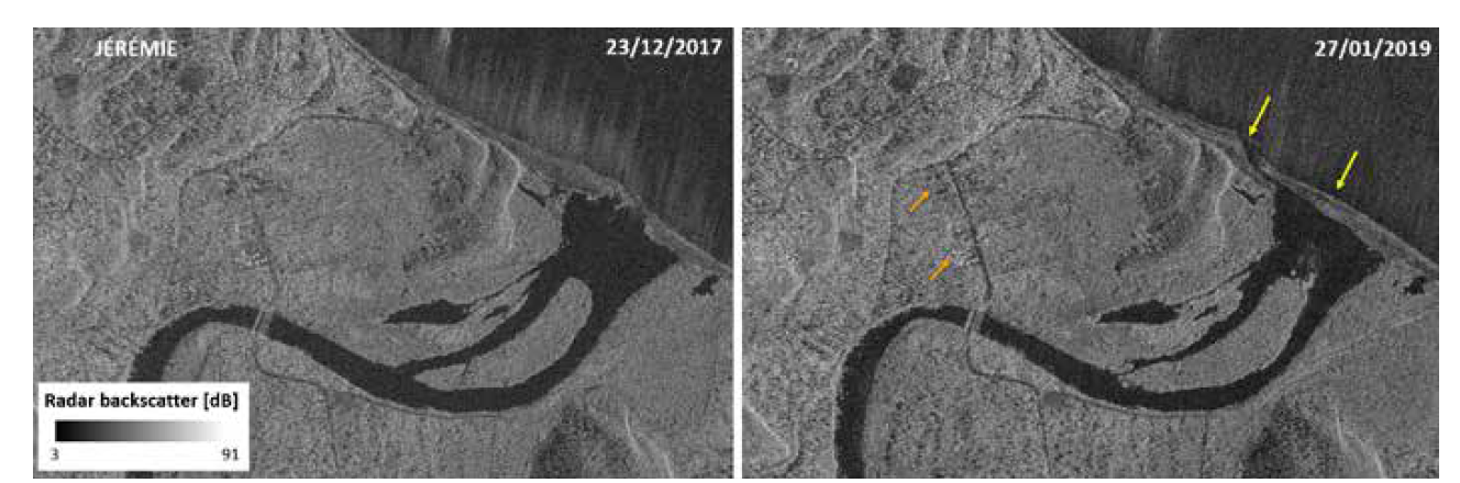
Satellite data can also provide valuable information for planning recovery strategies on natural resources. Even though natural hazards such as storms, floods and wildfires are often part of the natural disturbance cycle of many ecosystems, the effectiveness of the recovery process in different species depends on the hazard severity, the land use history and many other factors (Marlier et al. 2022). Remote sensing methods for environmental recovery are especially suited for early-stage damage detection and estimates when ground-surveys are not possible (Hamdi et al. 2019).
Satellite data can support recovery efforts in understanding which areas are heavily damaged, which species were affected the most, and where to make targeted ground assessments, identify the need for additional analyses to determine priority areas, tree species and investments for recovery, and to be able to monitor and assess recovery over time. One of many methodologies to identify tree mortality and damage and to perform a first assessment of ecosystem damage is change detection. Change detection allows experts to quantify changes in the non-photosynthetic vegetation, representing changes in the exposed wood and vegetation litter (Marlier et al. 2022). Other methods to assess forest damage include the use of highly accurate image classification algorithms of post-disaster images (Hamdi et al. 2019). Major satellites for environmental monitoring are Landsat 1-8, IKONOS-2, Quickbird, GeoEye, Envisat, SPOT (1-7) and Rapid Eye (Sudha & Sivanandan 2023).
Monitoring the progress of environmental and agricultural restoration efforts can play a key role in facilitating economic recovery. Using remote sensing data, it is possible to track crop yields and pinpoint areas where economic activity may have been disrupted. This valuable information can then be utilized to support initiatives aimed at revitalizing local economies and aiding communities in their recovery efforts (Marlier et al. 2022).
3. Organizations involved in satellite-based disaster recovery
Several international actors and organizations support recovery efforts in the aftermath of a disaster by providing geospatial information and guidance, two of them are the Copernicus Emergency Management Service and the Committee on Earth Observation Satellites (CEOS).
3.1 Copernicus Emergency Management Service
The Copernicus Emergency Management Service (CEMS), a service implemented by the European Commission, provides support to recovery efforts through its Risk and Recovery Mapping service (RRM). RRM provides on-demand geospatial information for the phases of the disaster risk management cycle related to preparedness and recovery from optical and radar satellite images (CEMS 2023). Information on how to activate, the offered products and the process of the CEMS Risks and Recovery Mechanism can be found on the Recovery Mechanism page of the UN-SPIDER Knowledge Portal and the CEMS Risk and Recovery Mapping website.
The Risk and Recovery Mapping service offers products that can support a wide range of activities in the context of recovery, disaster risk reduction and preparedness. Offered products for post-event mapping include the assessment of recovery needs, mapping the long-term impact of the disaster event, monitoring progress in reconstruction efforts and supporting cost-benefit analysis. Most products are composed of reference maps and pre- and post-disaster situation maps.
- Reference maps provide a comprehensive and updated knowledge of the territory and relevant assets in a disaster risk reduction context.
- Pre- and post-disaster situation maps provide relevant and up-to-date thematic information for recovery needs. By comparing and interpreting images before and after a specific event many recovery efforts, such as damage assessment, reconstruction monitoring or vegetation recovery monitoring can be supported.
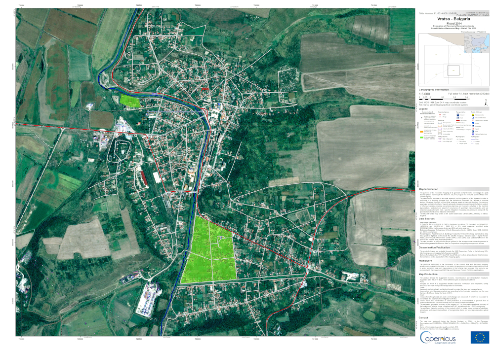
An example of products created by the Risk and Recovery Mapping service can be seen in Figure 8. The purpose of the requested mapping activation was to generate comprehensive knowledge and information at a post disaster phase, referring to the flood on July 31st, August 1st and 2nd, 2014 in Mizia town, Bulgaria. The product shows the recovery, reconstruction and rehabilitation measures suggested after the flood. Three different types of actions were defined:
- Bridges for which it is suggested detailed hydraulic verification and adaptation, taking account of any new configurations/upgrades of the levees.
Linear:
- Levees to be hydraulically verified/reinforced to protect the town and industrial areas.
- Levees that need thorough analysis as, according to the hydraulic modelling, are the ones that have first failed during the flood of 2014.
Areal:
- Areas where the greatest pre-post event changes are observed, in which it is necessary to concentrate the reconstruction/mitigate activities.
- Areas where the construction of cross-protection is recommended to prevent flow of upstream flood water volumes towards the built areas located downstream.
3.2 Committee on Earth Observation Satellites
The Committee on Earth Observation Satellites (CEOS) is a forum for international coordination of space-based Earth observation and is composed of a variety of space agencies working in the field of Earth observation. The CEOS Working Group on Disasters has focused among other things on recovery in the aftermath of disasters, developing the Recovery Observatory (RO). The aim is to facilitate access to relevant space-based information to support end users in their decision-making processes regarding recovery planning and to monitor recovery progress. More information on the CEOS Recovery Observatory can be found on the Recovery Mechanism page of the UN-SPIDER Knowledge Portal and on the CEOS RO website.
As a pilot project, the Recovery Observatory (RO) monitored the recovery efforts after the hurricane devastation in Haiti in 2017. Together with Haitian partners several recovery themes, such as the recovery of buildings, transport networks, agricultural activities, watershed, terrain motion and environmental rehabilitation were monitored and cartographic products were created to visualize the results. Additionally, using the concept of Recovery Observatories, CEOS, together with the Global Facility for Disaster Risk Reduction of the World Bank (GFDRR), the United Nations Development Programme (UNDP) and the European Commission, aims to facilitate the elaboration of Post-Disaster Needs Assessments (PDNAs). CEOS foresees further development and testing of several Recovery Observatory pilot projects in different parts of the world, covering if feasible all continents, before releasing it as fully operational service.
4. References
Committee on Earth Observation Satellites (CEOS): The European Union, Global Facility for Disaster Reduction and Recovery (GFDRR), United Nations Development Program (UNDP), The World Bank Group (2019). Use of EO Satellites in Support of Recovery from Major Disasters. Retrieved from https://www.gfdrr.org/sites/default/files/publication/Use_of_EO_Satellites_012322020_D_LOW-RES.pdf
Committee on Earth Observation Satellites (CEOS) (n.d.): Recovery Observatory. Retrieved from: https://ceos.org/ourwork/workinggroups/disasters/recovery-observatory/
Copernicus Emergency Management Service (CEMS) (2023): Mapping for Disasters and Crises in Support to EU Delegations. Available at: https://emergency.copernicus.eu/mapping/sites/default/files/files/CopernicusEMS-EU_Actors_Worldwide_Brochure.pdf (last accessed 19/04/2023)
Contreras, D., Blaschke, T., Tiede, D. & Jilge, M. (2016): Monitoring recovery after earthquakes through the integration of remote sensing, GIS, and ground observations: the case of L’Aquila (Italy). Cartography and Geographic Information Science, 43(2), 115-133, https://doi.org/10.1080/15230406.2015.1029520
Ghaffarian, S.; Rezaie Farhadabad, A.; & Kerle, N. (2020): Post-Disaster Recovery Monitoring with Google Earth Engine. Appl. Sci. 2020, 10, 4574. https://doi.org/10.3390/app10134574
Ghaffarian, S., & Emtehani, S. (2021): Monitoring urban deprived areas with remote sensing and machine learning in case of disaster recovery. Climate, 9(4), 58.
Hamdi Z., Brandmeier M. & Straub C. (2019): Forest Damage Assessment Using Deep Learning on High Resolution Remote Sensing Data. Remote Sensing, 11(17), 1976. https://doi.org/10.3390/rs11171976
Krishnamoorthi, N. (2016). Role of Remote Sensing and GIS in Natural Disaster Management Cycle: Imperial Journal of Interdisciplinary Research (IJIR). 2(3), 144-154
Marlier, M., Resetar, S., Lachman, B., Anania, K. & Adams, K. (2022): Remote sensing for natural disaster recovery: Lessons learned from Hurricanes Irma and Maria in Puerto Rico. Environmental Science and Policy 132, 153-159. https://doi.org/10.1016/j.envsci.2022.02.023
Sudha S. & Sivanandan, Aji. (2023): Delving Into Geospatial Data Services: Monitoring Earth For Covid-19 Impact Measure And Decision Making. International Journal of Progressive Sciences and Technologies (IJPSAT), 37(2), 136-154.
Sutton, P., Elvidge, C. & Ghosh, T. (2007): Estimation of gross domestic product at sub-national scales using night-time satellite imagery. International Journal of Ecological Economics & Statistics (IJEES), 8(S07), 5–21.
United Nations Office for Disaster Risk Reduction (UNDRR) (2015): Sendai Framework for Disaster Risk Reduction 2015 – 2030. Retrieved from: https://www.preventionweb.net/files/43291_sendaiframeworkfordrren.pdf?_gl=1*8jne0q*_ga*MTcxMDczNTk0My4xNjgxOTA4MDQx*_ga_D8G5WXP6YM*MTY4MTkwODA0MS4xLjAuMTY4MTkwODE3OS4wLjAuMA
World Bank (2023): Syria Earthquake 2023: Rapid Damage and Needs Assessment. Washington, DC: World Bank. https://elibrary.worldbank.org/doi/abs/10.1596/39610