• English
  • Español
  • Français

United
Nations


Office for Outer Space Affairs
UN-SPIDER Knowledge Portal

  • Accueil
  • À propos
    • Qu'est-ce que l'ONU-SPIDER?
    • À propos d’UNOOSA
    • Publications
    • Offres d'emploi
    • Rencontrez l'équipe
    • Contact
  • Applications spatiales
    • Technologie satellitaire
    • Mécanismes d’urgence
    • Recovery Mechanisms
    • Réseau international d'alerte aux astéroïdes
    • Space Mission Planning Advisory Group
    • Initiative internationale sur la météorologie spatiale
    • Les technologies spatiales à l'ONU
    • Comptes-rendus d'utilisateurs
  • Liens & ressources
    • Application de données du mois
      • Disaster Recovery
    • Sources de données
    • SIG et logiciels de télédétection
    • Online Learning Resources
    • Institutions
  • Risques & catastrophes
    • Prévention des risques de catastrophe
    • Systèmes d'alerte précoce
    • Gestion des catastrophes et des interventions d'urgence
    • Aléas naturels
    • Cadre d'action de Sendai
    • L'ONU et la prévention des risques de catastrophe
    • L'ONU et les alertes précoces
    • L'ONU et la gestion des catastrophes
  • Appui technique
    • Missions Conseil
    • Appui d’urgence
    • Appui à distance
    • Pratiques recommandées
    • Activités de formation
    • Utilisations pratiques
  • Réseaux
    • Bureaux régionaux d’appui
    • GP-STAR
    • MHEWS
    • IWG-SEM
  • Projets
    • SPEAR
    • SEWS-D
    • EvIDENz
    • Flood GUIDE
    • CommonSpace Initiative
    • Tonga Pilot Project
  • Actualités
    • Actualités
    • Événements
    • Événements passés

Breadcrumb

  • Home
  • Flooding In Namibia Part of The First Data Acquisition From Sentinel-1
  • Flooding in Namibia part of the first data acquisition from Sentinel-1

Flooding in Namibia part of the first data acquisition from Sentinel-1

Sentinel -1 first images receivedFlooding in Namibia

The Sentinel-1 satellite of the European Space Agency delivered its first images. As UN-SPIDER reported, the satellite was launched successfully on 3 April. The mission is the first of ESA’s Copernicus environmental monitoring programme.

Though not yet fully operational, first images are offering a glimpse into the satellites capabilities. After conclusion of the calibration phase, Sentinel-1 will start its operational phase in the next couple of months.

The Director of ESA’s Earth Observation Programmes, Volker Liebig, commented, “We are in very early days of the satellite’s life in orbit and ground segment operations, but these images certainly demonstrate the caliber of data this advanced radar mission will bring from its different imaging modes, and how it will provide essential data for Copernicus services to benefit us all.”

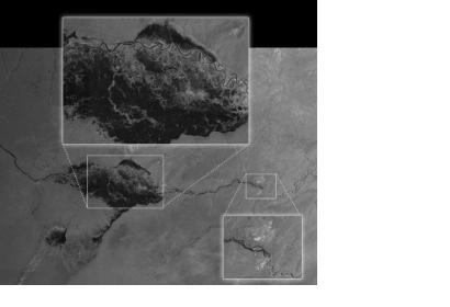
One of the first received images covers flooding in Namibia. The radar image shows the extent of flooding in the Caprivi plain from the Zambezi River. It was received two hours after acquisition and resulting products were available in less than an hour. One of the great advantages of the satellite's sensor is the ability to acquire such images in all weather conditions, day and night.

Other images from the first set include Brussels and Island's Thwaites Glaciers. 
ESA
Thu, 17 Apr 2014 - 12:29
Namibia

Footer menu

  • Contact
  • Terms of Use

User account menu

  • Log in