Worldwide, storm surges pose a threat to coastal communities. Particularly in low-lying African coastal cities, the impact of climate change induced storms and sea level rise is a threat to the vulnerable community (Nhantumbo et al. 2023). Especially with climate change, this hazard is likely to intensify (IPCC 2022), calling for urgent action. To identify the exposed groups, assets, and infrastructure, and to implement effective storm surge risk management, an understanding of the hazard, its timing, and geographic patterns is crucial. Hazard maps can serve as a first approximation for estimating the spatial extent of storm surges and sea level rise, as well as the exposed population and assets.
For detailed hazard maps, hydrodynamic models are often used due to the complexity of storm surges. They are influenced by factors such as storm intensity, the storm's track, bathymetry, and more. Hydrodynamic modeling therefore requires high-quality and complex parameters, such as historical data sets or detailed coastal formation data for a specific area, which are not always available or may be costly to obtain. This makes free, detailed modeling of storm surges very challenging.
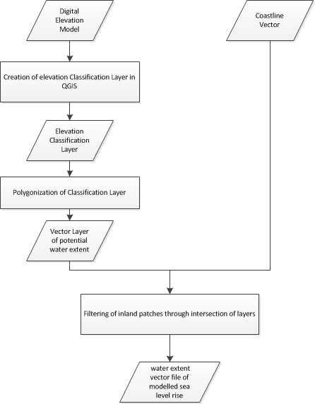
Other methods, such as the bathtub approach, require fewer datasets and can serve as a first approximation for modeling the potential geographical extent of coastal flooding. This Recommended Practice outlines the steps to visualize the geographical extent of coastal flooding or sea level rise using just two datasets: a digital elevation model (DEM) and a shoreline dataset. The choice of a DEM is crucial; preferably, a high-resolution DEM should be used, as it is more likely to represent the surface accurately. However, high-resolution datasets are not always available for free. In such cases, a mid-resolution DEM, such as the Copernicus 30m DEM, which is globally accessible, should be used when open-access DEMs are the only option.
The flood masks created during this practice can be further used to identify exposed elements in specific regions. The Recommended Practice on Exposure Mapping can be applied for that (Link: https://www.un-spider.org/advisory-support/recommended-practices/recommended-practice-exposure-mapping ).
Computer Requirements
To perform the step-by-step procedure, it is required to install QGIS (preferred 3.28.15 Firenze or newer version).
Required Datasets
- Digital Elevation Model (e.g. Copernicus 30m DEM, WorldDEM neo)
- Coastline vector layer (e.g. OpenStreetMap water-body layer, WorldDEM Ocean shoreline a product of Airbus)
You can freely download the Copernicus 30m DEM from the OpenTopography, CODE-DE or the Copernicus Data Space Ecosystem website as described on the step-by-step page.
- Develop scenarios of impacts of storm surges in specific coastal areas;
- Conduct an initial assessment of risk associated with storm surges;
- Improve storm surge early warning systems using scenarios of the extent of coastal flooding.
Strengths:
- Can be used in all coastal areas of the world, the COP30 DEM and other commercial DEMs are available globally
- Free and open-source software can be used (e.g. Quantum GIS)
COP30 DEM:
- Resolution: 1 arcsec (approx. 30m)
- Absolute vertical accuracy: < 4m (90% linear error)
- Relative vertical accuracy: < 2m (slope <= 20%) / < 4m (slope <= 40%)
Limitations and Restrictions:
The globally accessible Copernicus DEM has a resolution of 30 m. When using this dataset, finer details may be omitted due to its resolution.
To address this limitation, alternative datasets with higher resolution can be considered. One such dataset is the WorldDEMneo from Airbus. However, for some regions there are restrictions regarding geographic availability. Consult with Airbus to determine whether data can be supplied for your region of interest.
DLR Document: TD-GS-PS-0021 (2016). TanDEM-X Ground Segment - DEM Products Specification Document, Issue 3.1, 05.08.2016. Available at https://tandemx-science.dlr.de/pdfs/TD-GS-PS-0021_DEM-Product-Specification_v3.1.pdf
IPCC (2021): Climate Change 2021: The Physical Science Basis. Contribution of Working Group I to the Sixth Assessment Report of the Intergovernmental Panel on Climate Change. V. Masson-Delmotte, P. Zhai, A. Pirani, S. L. Connors, C. Péan, S. Berger et al.United Kingdom and New York, NY, USA.
Nhantumbo, B., Dada, O. A. and f. E.K. Ghomsi (2023): Sea Level rise and Climate Change – Impacts on Africal Coastal Systems and Cities. DOI: 10.5772/intechopen.113083
World Meteorological Organization (2011). Guide to Storm Surge Forecasting. Publication No. 1076. Geneva, Switzerland, 2011. Available at: https://library.wmo.int/pmb_ged/wmo_1076_en.pdf