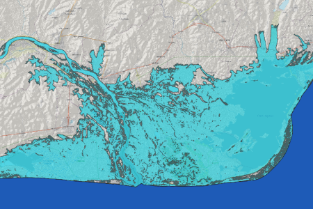
This Recommended Practice allows users to visualize the geographical extent of coastal flooding or sea level rise on a local, regional, or global scale (depending on the resolution and accuracy of the incoming digital elevation model). It can be used exclusively as a first approximation to determine areas that are prone to inundation and can serve as a first assessment for further, more in-depth analysis of coastal flood and sea level rise assessment.
This version of the Recommended Practice is a revision (2024) of the original storm surge RP using the openly accessible and free Copernicus Digital Elevation Model with a resolution of 30 meters. The original version of the RP makes use of the commercial high-resolution (12 m) World Digital Elevation Model (WorldDEMTM) product of Airbus Defence and Space. However, both versions can be used with both datasets, Cop DEM and WorldDEM, but the examples / case studies differ.
For the sake of clarity - the Recommended Practice has not been developed for any other use and purpose than the above described one and is consequently not usable for and in navigation, any hazardous environment requiring error free performance.
The coastal region of Ghana was heavily affected by tidal waves in June 2017. Many people have been displaced and houses, infrastructure and fishing gear (boats, nets) destroyed. This Recommended Practice can be a first assessment to apply further analysis to identify safer ground for relocation of exposed communities. For more information please refer to this link provided by the National Disaster Management Organization of Ghana (NADMO).
ZFL / University of Bonn contact:
For any questions related to the revision of the Recommended Practice and the usage of the COP30 DEM, feel free to get in touch with the author or spokesperson at ZFL:
Josi Bregulla
josi.bregulla [at] uni-bonn.de
Michael Schmidt
michaelschmidt [at] uni-bonn.de
Airbus contact:
For any questions related to Airbus disaster management applications using Earth Observation technology or WorldDEMTM product, feel free to get in touch with the original authors:
Ciro Farinelli
Future SAR Programs Manager, Airbus Defence and Space / Intelligence
ciro.farinelli [at] airbus.com
Virginia Herrera-Cruz
Application Developer, Airbus Defence and Space / Intelligence
Virginia.herrera [at] airbus.com
The model can be applied to any coastal region of the world because open-access data was used.
