  • English
  • Español
  • Français

United
Nations


Office for Outer Space Affairs
UN-SPIDER Knowledge Portal

  • Accueil
  • À propos
    • Qu'est-ce que l'ONU-SPIDER?
    • À propos d’UNOOSA
    • Publications
    • Offres d'emploi
    • Rencontrez l'équipe
    • Contact
  • Applications spatiales
    • Technologie satellitaire
    • Mécanismes d’urgence
    • Recovery Mechanisms
    • Réseau international d'alerte aux astéroïdes
    • Space Mission Planning Advisory Group
    • Initiative internationale sur la météorologie spatiale
    • Les technologies spatiales à l'ONU
    • Comptes-rendus d'utilisateurs
  • Liens & ressources
    • Application de données du mois
      • Disaster Recovery
    • Sources de données
    • SIG et logiciels de télédétection
    • Online Learning Resources
    • Institutions
  • Risques & catastrophes
    • Prévention des risques de catastrophe
    • Systèmes d'alerte précoce
    • Gestion des catastrophes et des interventions d'urgence
    • Aléas naturels
    • Cadre d'action de Sendai
    • L'ONU et la prévention des risques de catastrophe
    • L'ONU et les alertes précoces
    • L'ONU et la gestion des catastrophes
  • Appui technique
    • Missions Conseil
    • Appui d’urgence
    • Appui à distance
    • Pratiques recommandées
    • Activités de formation
    • Utilisations pratiques
  • Réseaux
    • Bureaux régionaux d’appui
    • GP-STAR
    • MHEWS
    • IWG-SEM
  • Projets
    • SPEAR
    • SEWS-D
    • EvIDENz
    • Flood GUIDE
  • Actualités
    • Actualités
    • Événements
    • Événements passés

Breadcrumb

  • Home
  • CSSTEAP Analyses Sardoba Dam Failure
  • CSSTEAP analyses Sardoba dam failure

CSSTEAP analyses Sardoba dam failure

Sentinel-2 imagery of the area on 4 May. Image: CSSTEAP.Sentinel-2 imagery of the area on 4 May. Image: CSSTEAP.

Using space-based information, the Centre for Space Science and Technology Education in Asia and the Pacific (CSSTEAP) affiliated to the United Nations has analysed the recent failure of a dam around the Sardoba Reservoir in Uzbekistan. Following a week of heavy rain in the region, the wall of the dam broke on 1 May and flooded surroundings in Uzbekistan as well as Kazakhstan to the north. According to media reports, the breach led to the evacuation of thousands of people in the area. 

The analysis carried out by CSSTEAP makes use of MODIS multi-temporal satellite images to identify the maximum spread of the floods, which was observed on 2 May. Waters receded in the following days, although they are still visibile along the border between the two countries on imagery from 12 May.

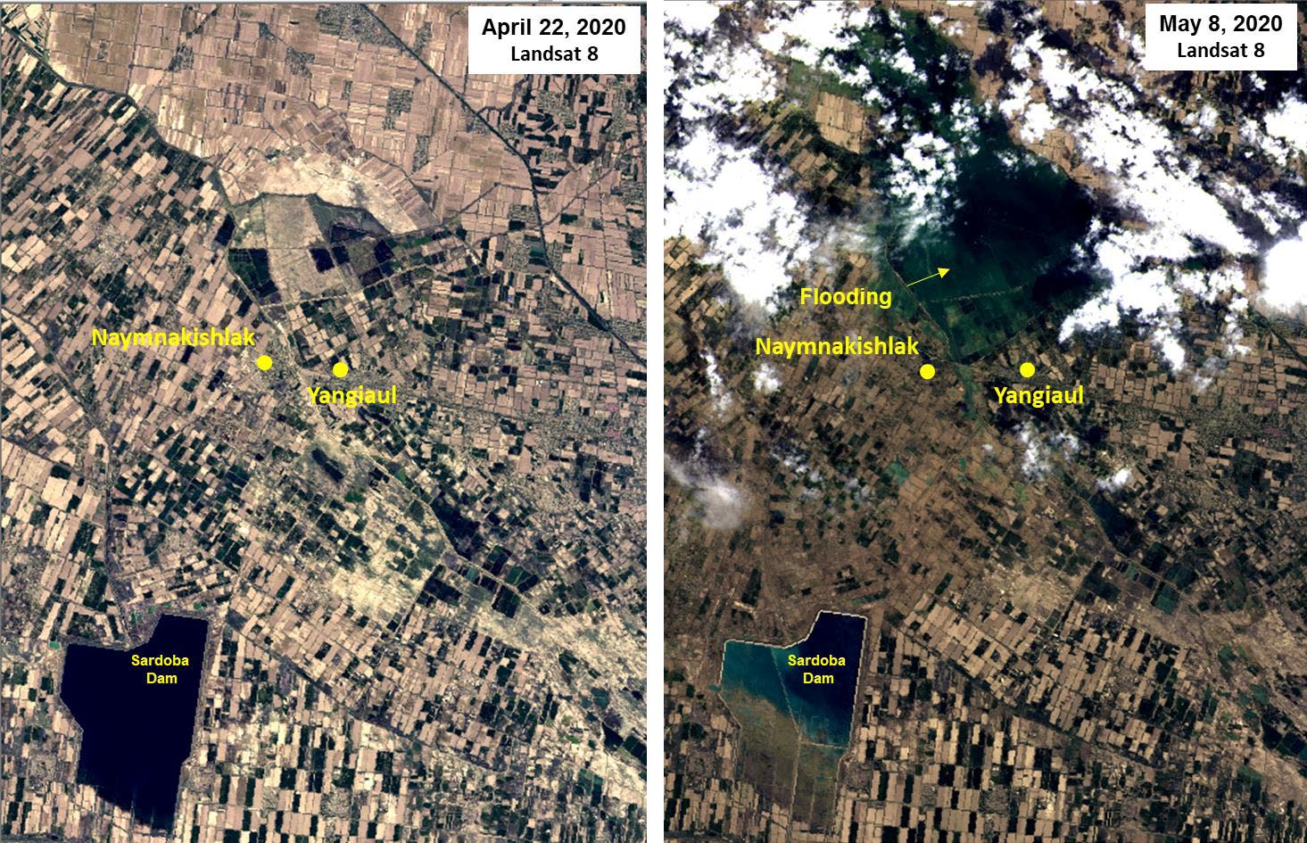
With the help of Landsat 8 and Sentinel-2 optical imagery, CSSTEAP concludes that settlements in the area appear to be severly impacted by the water, which flowed into low-lying regions as there is a 20m elevation drop from the dam to the border region. Optical imagery from before and after the event also helps identify a 270m long breach of the dam's wall.

Image: CSSTEAP.
Image: CSSTEAP.
 
CSSTEAP is one of six Regional Centres for Space Science and Technology Education (affiliated to the United Nations) across the globe. It regularly supports UN-SPIDER capacity-building activities in the region.
 
Sardoba dam failure Uzbekistan: Satellite-based observations
Tue, 19 May 2020 - 16:55
Kazakhstan
Uzbekistan
Flood
Aqua
Landsat 8
Sentinel-2A
Sentinel-2B

Footer menu

  • Contact
  • Terms of Use

User account menu

  • Log in