• English
  • Español
  • Français

United
Nations


Office for Outer Space Affairs
UN-SPIDER Knowledge Portal

  • Accueil
  • À propos
    • Qu'est-ce que l'ONU-SPIDER?
    • À propos d’UNOOSA
    • Publications
    • Offres d'emploi
    • Rencontrez l'équipe
    • Contact
  • Applications spatiales
    • Technologie satellitaire
    • Mécanismes d’urgence
    • Recovery Mechanisms
    • Réseau international d'alerte aux astéroïdes
    • Space Mission Planning Advisory Group
    • Initiative internationale sur la météorologie spatiale
    • Les technologies spatiales à l'ONU
    • Comptes-rendus d'utilisateurs
  • Liens & ressources
    • Application de données du mois
      • Disaster Recovery
    • Sources de données
    • SIG et logiciels de télédétection
    • Online Learning Resources
    • Institutions
  • Risques & catastrophes
    • Prévention des risques de catastrophe
    • Systèmes d'alerte précoce
    • Gestion des catastrophes et des interventions d'urgence
    • Aléas naturels
    • Cadre d'action de Sendai
    • L'ONU et la prévention des risques de catastrophe
    • L'ONU et les alertes précoces
    • L'ONU et la gestion des catastrophes
  • Appui technique
    • Missions Conseil
    • Appui d’urgence
    • Appui à distance
    • Pratiques recommandées
    • Activités de formation
    • Utilisations pratiques
  • Réseaux
    • Bureaux régionaux d’appui
    • GP-STAR
    • MHEWS
    • IWG-SEM
  • Projets
    • SPEAR
    • SEWS-D
    • EvIDENz
    • Flood GUIDE
  • Actualités
    • Actualités
    • Événements
    • Événements passés
  • Admin
    • SAM Items

Breadcrumb

  • Home
  • EEA And ESA Strengths Cooperation On Earth Observation And Environmental Monitoring
  • EEA and ESA strengths cooperation on Earth Observation and environmental monitoring

EEA and ESA strengths cooperation on Earth Observation and environmental monitoring

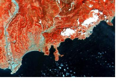
French Riviera processed through infrared spectral channel, one of the first images captured by Sentinel-2A satellite (Image: ESA)French Riviera processed through infrared spectral channel, one of the first images captured by Sentinel-2A satellite (Image: ESA)

A Memorandum of Understanding was signed on July 15 between the European Space Agency (ESA) and the European Environmental Agency (EEA) in order to share scientific expertise and technical data in the fields of Earth Observation and environmental monitoring through satellite imagery.

One of the novelties is the agreement on the employment of the brand-new Sentinel-2A satellite, developed and launched by ESA, for the Copernicus Land Monitoring Service, which is coordinated by EEA. The space artifact is the second satellite of the European Union’s Copernicus programme and is specifically designed for environmental monitoring by providing colourful high resolution imagery in 13 spectral bands.

Not only does it offer data for the traditional meteorological and environmental monitoring programmes of EEA, but it can also be used for locating sites for refugee camps in humanitarian crises, monitoring the destruction or growth of forests and estimating fertilizer and water needs for efficient crop production.
European Environment Agency
Thu, 23 Jul 2015 - 11:56
Europe

Footer menu

  • Contact
  • Terms of Use

User account menu

  • Log in