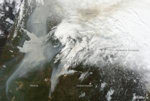
Fires throughout Ontario are generating pollution that is showing up in data from NASA's Aura Satellite in the Great Lakes region. The fires have also forced thousands of residents to evacuate to other areas in Canada, according to CBC News. About 112 fires have ravaged 81,545 acres so far, said the province's minister of natural resources, Linda Jeffrey. Because of the smoke from wildfires blowing south, the Minnesota Pollution Control Agency issued an air pollution alert, according to the Duluth News Tribune.
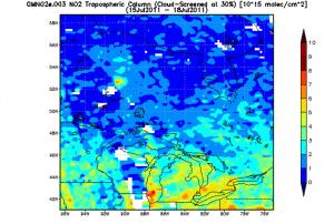
An image of the pollution from fires in Ontario was created from data of nitrogen dioxide (NO2) levels over the period from July 15, 2011 to July 18, 2011. It was created from Ozone Measuring Instrument (OMI) data using the NASA Giovanni system by Dr. James Acker at NASA's Goddard Space Flight Center in Greenbelt, Md.
NO2 forms during fires when nitrogen reacts with oxygen. In fact, NO2 is formed in any combustion process where the oxygen is provided by Earth's…
more