Algis B. Kucinskas, Planet Action, Spot Image* Individual Partner, Paris, France
This paper gives an overview of the Planet Action (PA) non-profit collaborative initiative with particular focus on its project support activities. PA was launched in 2007 to encourage the Earth observation and geographic information professional communities to help NGOs, local institutions and universities tackle climate change in a new cooperative approach.
General background / international communities’ needs
Following the conclusions of the Fourth Assessment Report of the Intergovernmental Panel on Climate Change (1, 2, 3) (IPCC, AR4, 2007) as well as updates from the 2009 Copenhagen Diagnosis (4) , it is now generally agreed that the Earth is currently experiencing large-scale climate change of both natural and anthropogenic (human-induced) causes with imminent and future adverse impacts on human society and the environment.
Indeed, as an evidence of observed climate change, there is now a very strong body of observational evidence showing that there has been an unusual increase in the global average (mean) temperature of the Earth’s lower atmosphere over the past century, with a particularly rapid increase since the mid-20th century. This upward trend in measured global mean temperatures and its projected continuation is often referred to as “global warming”. It is illustrated in Figure 1a and b, taken from the Copenhagen Diagnosis (4) (with data from NASA Goddard Institute for Space Studies/GISS and the Hadley Centre for Climate Prediction and Research).
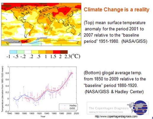
Figure 1 : (top) Mean surface temperature anomaly/change (°C) for the period 2001 to 2007 relative to the “baseline period” 1951 to 1980; map estimates are based on NASA Goddard Institute for Space Studies (GISS) data and (bottom) global average temperature from 1850 to 2009 relative to the “baseline period” 1880 to 1920 estimated from NASA/GISS and Hadley Centre for Climate Prediction and Research data. Figure taken from The Copenhagen Diagnosis, 2009 (4).
As many basic elements of human society and the environment are sensitive to climate variability and change it is to be expected that climate change/global warming will have significant socioeconomic and environmental effects/impacts (e.g., water resources, land use/agriculture, vulnerability to extreme events, coastal areas, ecosystems, human health,…). However, the extent of climate change effects/impacts will vary by region, over time and according to the vulnerability and adaptability of different societal and environmental systems.
Socioeconomic and environmental effects/impacts of climate change can be divided into current changes/impacts and probable projected changes/impacts for the future. These are discussed by (3) with more recent updates given in (4). The currently observed effects are expected to continue and amplify further, as most of the processes induced by global warming have a tendency to accentuate it.
Natural hazards-related disasters worldwide, but most notably in the developing world, have claimed many lives, injured many more, led to massive population displacement, caused severe damage to the natural and built environment, and seriously undermine efforts for achieving sustainable economic and social development. According to data and analysis by Munich Re (5), over the past decades there has been an upward trend in the number of natural disasters and related losses as a result of such factors as population growth, concentration of population in and industrialization of exposed, hazard/disaster prone areas, environmental degradation and, possibly, climate change.
Indeed, the potential future effects of global climate change include more frequent wildfires, more intense heat-waves, longer periods of drought in some regions and a projected increase in the frequency, duration and intensity of severe climatic/weather hazard events such as tropical storms and thus a likely increase in the number and scale of related disasters. In fact, the intensity and frequency of weather related hazard events has increased in many regions and there is mounting evidence that climate change is a factor (6, 7, 8).
Various sources (e.g., UNISPACE III (9), IGOs and NGOs,..) have noted that information derived from space-based technologies can be combined with other relevant geospatial data/information in a Geographic Information System (GIS) to provide insight and significant solutions to problems in such strongly linked areas of work as: addressing climate change, hazard/disaster risk reduction/management, human security, natural resources management, monitoring and protecting the environment, poverty reduction, public health, education, capacity building, and international development.
Remote sensing satellites, used to monitor land surface, oceans and the atmosphere, offer numerous advantages such as global coverage, repetitiveness, speed of data acquisition and consistency of collected data. Earth satellite imagery plays an important role in understanding what is currently happening and at what pace. GIS offer an integrated approach to storing, retrieving, manipulating, analyzing, integrating, displaying, comparing and interpreting spatially related sets of digital data from a variety of sources.
As an example of application, the use of RS EOS imagery and GIS technologies allows environmental scientists and local communities to assess and understand environmental changes/impacts linked to climate change as well as show the extent of human impact on the environment and to better prepare and evaluate adaptation strategies. In illustration of this, Figure 2 shows two Landsat Images of Mount Kilimanjaro in Tanzania, taken at the same season in 1976 and 2000, showing the shrinking snow cap. Kilimanjaro’s eternal snows have lost 82% of their surface since 1900. Satellites measure the snow cover at the summit of this 5895m high volcano at regular intervals.
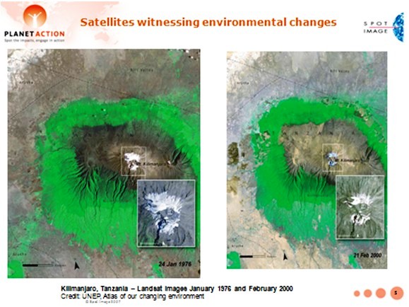
Figure 2 : Two Landsat images of Mount Kilimanjaro, Tanzania, taken in 1976 and 2000, showing the shrinking snow cap. Credit: UNEP.
Faced with the climate change crisis, and the human and environmental impact, there is an urgent need to take action to improve our understanding of climate change causes, better address current climate change impact assessment, contribute to reducing uncertainties in model projections as well as assess vulnerabilities to hazard-related disaster risks, and develop and implement comprehensive climate change mitigation and adaptation measures as well as comprehensive multihazard-related disaster risk reduction strategies.
Within the linked sectors of activity listed earlier there is an increasing need for readily accessible space technology data and information, along with the knowledge and tools required for analysis. Especially needed are value-added visual data analysis (“visualizations”) of different areas at different scales worldwide and GIS products addressing the needs of areas under consideration for more informed climate change mitigation and adaptation as well as disaster risk management-related planning, policy and decision-making.
It has also been noted that keys to the effective use of space, geo-information/GIS and other relevant technology applications for addressing socioeconomic and environmental impact issues include awareness raising, transfer of knowledge, and capacity building. Especially needed are educational and training initiatives, both traditional classroom and web-based e-learning with inclusion of case studies, for the use of such technologies (e.g., 10, 11, 12).
As noted by several sources (e.g., 3, 6, 7, 8, 13, 14, 15, 16) there is an increased awareness/recognition that the climate change mitigation and adaptation (CCMA) and disaster risk reduction/management (DRRM) communities are closely linked. Indeed, climate change increases disaster risk through processes like temperature and sea-level rise, changing precipitation patterns, rapidly expanding coastal cities and likely/projected increase in the frequency and/or severity of weather and climate hazard events with simultaneous increase in societal vulnerability to natural hazards.
The Planet Action (PA) Initiative: Earth Observation and GIS communities tackling the climate crisis
In response to international communities needs and the preoccupying climate change situation, Planet Action (hereafter PA) was launched in June 2007 by Spot Image as a non-for-profit collaborative “corporate citizenship initiative” to encourage the Earth observation and GIS professional communities to help NGOs, large organizations, local institutions and universities/research centers deal with issues in relation with climate change and encourage action in a new cooperative approach.
The PA vision or broad objective consists in tackling climate change at a local scale for a global benefit, using Earth observation and GIS technologies. This vision was largely motivated by the belief that, faced with the climate change emergency and its negative impacts, the Earth observation and geo-information/GIS industries have a strong potential to help (scientifically and practically) and should take action thanks to: 1) extensive earth observation means/technologies and services; 2) vast archives of data/images in various resolutions and from various sources(optical and radar satellites, airborne images, …) accumulated over 20 years (with more than 20 million images) for SPOT and 25 years for Landsat, time-series data,…; 3) extensive experience in analyzing and understanding Earth imagery; 4) GIS software and dynamic users’ networks; 5) a worldwide network of partner operators and receiving stations, as well as a large network of scientists, scholars and educators.
One can list three PA core objectives: 1) build capacity to understand and act upon climate change related issues and to support any local project, big or small, whether from scientific or civil societies, engaged in research and action addressing climate change causes, vulnerability, mitigation, impacts, adaptive solutions/measures and related hazard/disaster risk reduction/management for a global benefit; 2) to support cooperation within and between project teams, local communities, global organizations and to use Earth imagery and GIS as a link between these communities; 3) to raise the awareness of/educate any individual or community about climate change, the benefits of Earth observation imagery, derived geospatial information and GIS technologies, and the role of local NGOs, scientists and educators as they handle these issues.
Current actions of PA related to these core objectives include: 1) Active and ongoing support to local projects that meet the PA criteria (see below) by providing expertise and donating remote sensing data/images from different EOS (SPOT constellation, Formosat-2, Quickbird,...) to relevant organizations. PA partners (co-founder ESRI, ITT, Trimble) donate GIS and image processing tools; 2) acting as a climate change information and knowledge exchange platform, fostering cooperation between implicated communities, through the PA website (www.planet-action.org) a common depository of knowledge generated around the projects (case studies) and the expected feedback; 3) awareness raising through global education and outreach programmes supported by the PA projects and website. Projects supported by PA represent non-profit organizations worldwide and are a formidable source of rich content (each project “tells a story”); this content can be adapted to any background/level/age and told in schools (including to schoolchildren), associations or institutions.
Since its inception, PA has been joined by many contributing, project and outreach partners (PA also has an Ambassador, explorer Stéphane Lévin). Founding contributing partner Spot Image (a company created in 1982 by the French Space Agency CNES, currently owned by Astrium Services, an EADS company, and other European partners) is a world leader in the distribution of space-sourced geographic information products, services and solutions and is the commercial operator for the SPOT Earth observation satellites (see Figure 3). Co-founder ESRI is a leading GIS technologies provider. Other contributing partners include ITT, Trimble, NSPO, Digital Globe, CRISP, ITU, ESA and UNESCO.
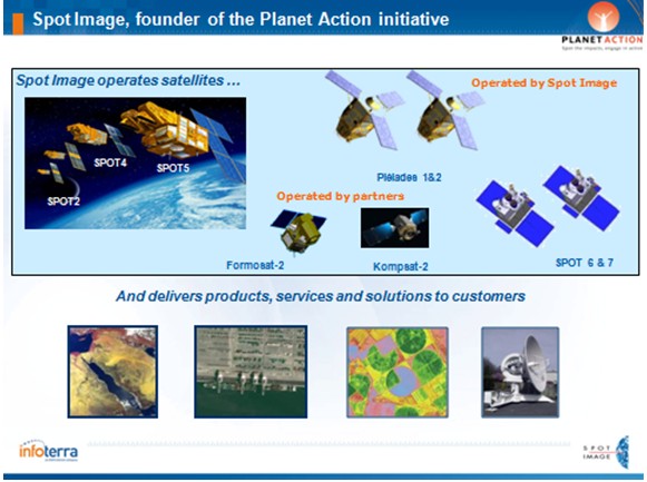
Figure 3 : Spot Image activities.
PA is currently supporting almost 400 projects worldwide (as illustrated in Figure 4). Projects investigate and assess climate change related issues in one or more of the following PA domains (fields of activity): Awareness, Biodiversity and Conservation, Drought and Desertification, Forest and Deforestation, Ice and Snow, Human Issues, Oceans and Coastlines, Water Resources.
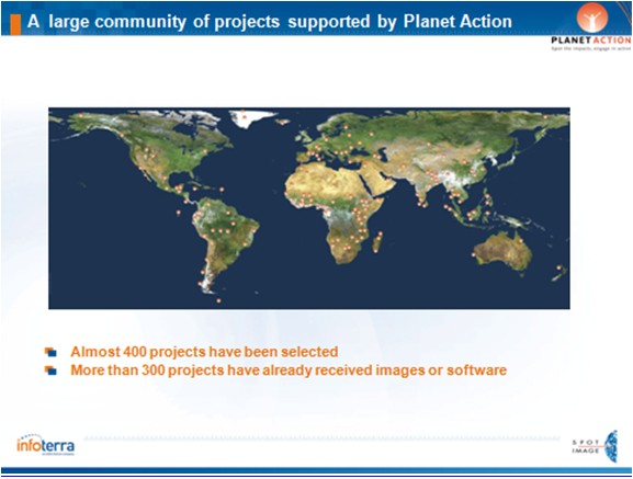
Figure 4 : Projects supported by Planet action are located on all continents and address a wide variety of topics.
NGOs, institutions and research laboratories engaged in action addressing climate change issues can submit their projects through the PA website using the on-line form. Projects should comply to the following eligibility criteria: - assess climate change related issues and propose a course of actions; - deal with at least one of the PA focus areas (currently eight); - have a member who resides in the country where the project takes place (at least for the project duration); - be proposed by a non-profit organization such as a NGO, a public laboratory or a university (business organizations do not qualify for direct support); - confirm that the project has no commercial objective; - confirm that the project has no religious or ideological content or objective. Additional criteria may be considered such as: - the importance and usefulness of the project for local populations; - a focus on building awareness, information, training or outreach activities that will result from the project; - specific methodologies supported by staff members or associated teams with an appropriate background for the work proposed.
PA then reviews and validates each proposal. Proposals which are accepted (validated) can then receive imagery and software. A typical PA project may require 5 to 10 satellite images per year-which may be provided either at once, or at different periods of time, as requested. Imagery may also have been acquired by different satellites, thus offering different characteristics (resolution, …). Once a project is validated, the Project Leader is commited to provide regular and formal feedback (posted on the PA website) for sharing of information/knowledge. For the interested reader, complete information on project submission is available at the PA website (www.planet-action.org).
Examples of supported projects / case studies
In a transfer of knowledge effort and as case studies examples for those readers who may be interested in submitting one or more proposals to PA, four selected projects having received support from PA are briefly presented below. The reader interested in obtaining more details on these and other projects is invited to visit the PA website.
Pan-Tropical mapping of forest cover project in Uganda (WHRC, UN-REDD Programme). PA domain: Forest & Deforestation.
This project is illustrated and summarized in Figure 5.
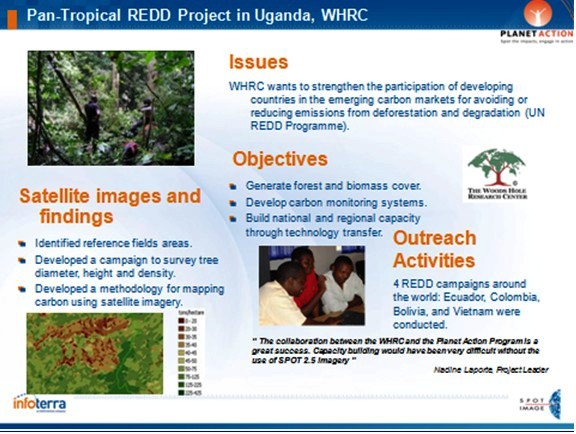
Figure 5 : Pan-Tropical mapping of forest cover project in Uganda (WHRC, UN-REDD Programme). PA domain: Forest & Deforestation.
The UN Programme for Reducing Emissions from Deforestation and forest Degradation (REDD) is a key issue as deforestation,particularly in tropical regions, is responsible for about 20% of global CO2 emissions.
The Woods Hole Research Center (WHRC) is a leading expert in forestry and has developed a method using satellite images to assess the biomass of forests (production of biomass/carbon maps) for improved forest management (including REDD). The outreach activities they ensure consist in explaining this method to populations (build national and regional capacity through technology transfer).Complete information on the REDD Programme is available at http://www.un-redd.org/
Reducing flood risks in the Philippines (GTZ). PA domain: Human issues.
The project is summarized in Figure 6.
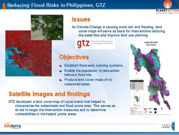
Figure 6 : Reducing flood risks in the Philippines (GTZ). PA domain: Human issues.
This project, which was discussed in a plenary presentation during the Fourth United Nations International UN-SPIDER Bonn Workshop (these Proceedings) (17), is highly technical and humanitarian at the same time. It involved the development of an early warning system that is currently under review with local government agencies and could save thousands of lives.
GTZ uses land cover maps of watershed areas in the Eastern Visayas, produced/updated by utilizing SPOT satellite images, to reduce the risk of flooding disasters.
Coral reef bleaching, Guadeloupe. PA domain: Oceans & Coast Lines and Biodiversity & Conservation.
The project is summarized in Figure 7.
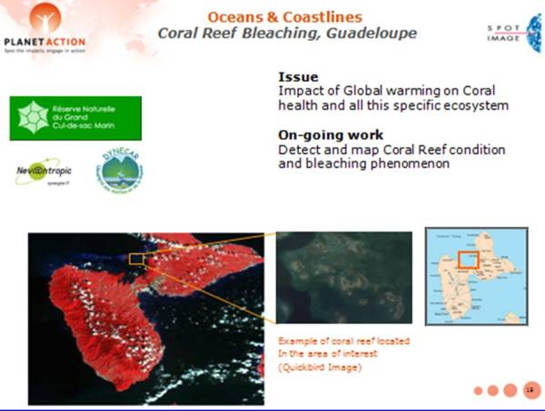
Figure 7 : Coral reef bleaching, Guadeloupe. PA domain: Oceans & Coast Lines and Biodiversity & Conservation.
Coral reefs provide direct benefits to human populations in tropical and subtropical coastal zones (e.g., sustain fisheries, provide protection from storm surges).Rising ocean temperature is a key factor behind increasingly frequent coral bleaching episodes. Also, rising CO2 levels affect ocean chemistry limit coral growth and its ability to recover from stresses like coral bleaching, which may lead to their death.
This may contribute to increasing the vulnerability of island nations.
Objectives of this project include the detection and mapping of coral reef condition and bleaching, as well as taking action to reduce human impacts on coral reef.
Glacial lake outburst flood (GLOF) risk assessment, Nepal (ICIMOD). PA domain: Human Issues.
The project is summarized in Figure 8.
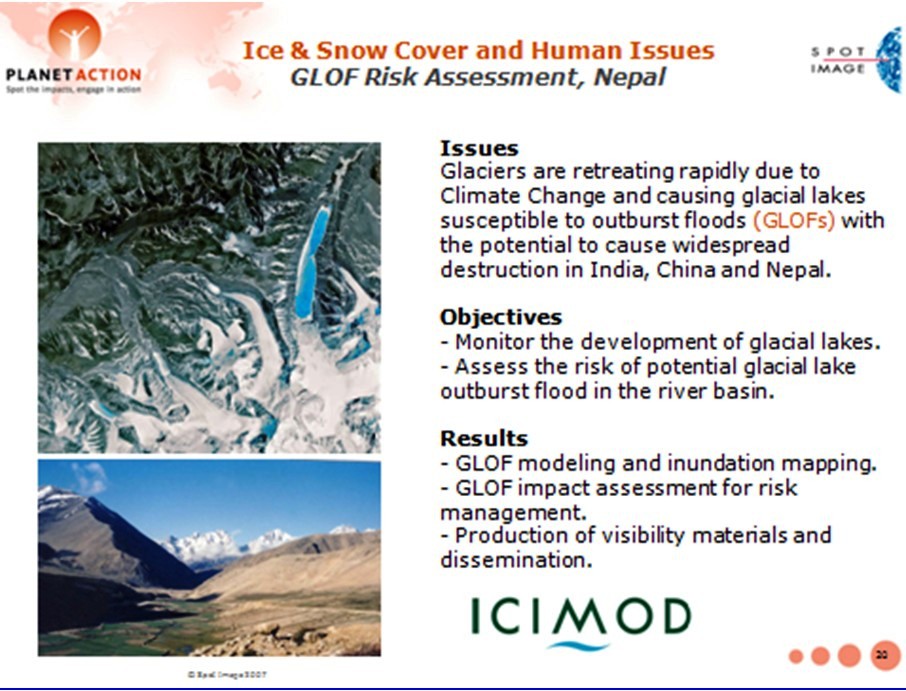
Figure 8 : Glacial lake outburst flood (GLOF) risk assessment, Nepal (ICIMOD). PA domain: Human Issues.
The globally observed retreat of glaciers is an example where climate change may lead to new threat levels, with the accumulation of water in natural moraine dams as a result of glacial melt potentially leading to glacial lake outburst floods (so-called GLOFs). With destructive down-stream effects, GLOF events can have serious impacts on the infrastructure, lives and livelihoods of mountain communities, with far-reaching socio-economic consequences.Many lakes in the Himalayas are categorized as potentially dangerous.
Objectives of this project were to monitor the growth of glacial lakes using high resolution SPOT imagery and manage GLOF risks to which populations are exposed. The project included an awareness-raising and training campain.
Examples of education- and outreach activities
In this section two representative PA educational and outreach activities are presented.
PA exhibit at the Cité de l’Espace, space science park in Toulouse.
As shown in Figure 9, PA has partnered with the Cité de l’Espace in Toulouse, a first rate science museum, to exhibit 20 projects which illustrate the use of satellite imagery and GIS technology in combating the climate change crisis.
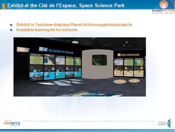
Figure 9 : PA exhibit at the Cité de l’Espace, space science park in Toulouse.
Developing awareness on the Green Belt Movement in Kenya.
PA and explorer Stéphane Lévin met with the Geen Belt Movement (GBM) for awareness action on climate change adaptation in Kenya (Figure 10). Indeed, the GBM, led by Wangari Maathai, the Nobel Prize for Peace in 2004, is pursuing a reforestation plan and has planted 40 million trees in Kenya since its foundation, demonstrating the bebefits of this type of action to local populations. The GBM turned to PA to help it better protect and monitor Kenya’s forests, and to plan reforestation strategies.
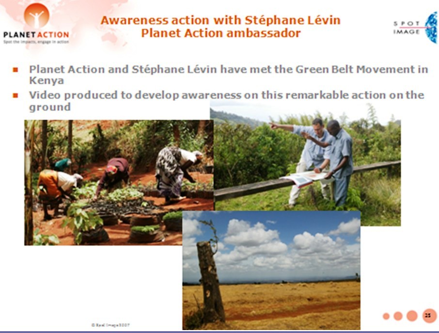
Figure 10 : Developing awareness on the Green Belt Movement in Kenya.
Conclusions
The PA Programme brings useful support (RS EOS imagery, GIS, expertise) to local projects, big & small, dealing with climate change issues (causes, mitigation, vulnerability, impact assessment, adaptation) and associated multihazard-related disaster risk reduction & management (DRRM).
In the context of the global climate change emergency and projected increases in the number and scale of hydro-meteorological hazard events and related disasters, PA offers a means of addressing several of the urgent needs related to the CCMA and DRRM sectors of activity (and also to poverty reduction and development) as discussed in Section 1 of this work.
PA has been joined numerous partners and has already provided support to a large number of projects worldwide, with substantial socioeconomic and environmental benefits.
Indeed, evaluation of PA project-related activities has demonstrated that the Programme works and creates value for all the partners involved. Especially appreciated by concerned communities and users is project/case study feedback with posting of results on the PA website.
PA will be supporting additional projets this year and will be following up on current projects. Education/outreach activities may be expanded (consider e-learning?) with new partners always welcome. PA will also continue to support communication, coordination and cooperation within and between project teams, local communities and global organizations using satellite imagery and GIS as well as the sharing of information/knowledge and experiences as a link. In particular, an important goal would be to contribute to the development of coordinated efforts between the closely linked CCMA and DRRM communities. Finally, PA may consider sharing a number of its projects/case studies with UN-SPIDER, for potential inclusion within the UN-SPIDER Communication and Information Platform (Web based Knowledge Portal).
Acknowledgments
The author wishes to thank the Planet Action team in Toulouse, in particular Patricia Dankha and Isabel Ortega, for their help and suggestions which were very useful in the completion of this work. The author is also grateful to Robert Backhaus, Natalie Epler and Ashley Lin of the UN-SPIDER Office in Bonn for their kind advice and support.
References
- IPCC, 2007: Climate Change 2007: The Synthesis Report: Summary for Policymakers. Contribution of Working Group I (WGI) to the Fourth Assessment Report of the Intergovernmental Panel on Climate Change (2007).
- IPCC, 2007: Climate Change 2007: The Physical Science Basis. Contribution of Working Group I (WGI) to the Fourth Assessment Report of the Intergovernmental Panel on Climate Change (2007).
- IPCC, 2007: Climate Change 2007: Impacts, Adaptation, and Vulnerability. Contribution of Working Group II (WGII) to the Fourth Assessment Report of the Intergovernmental Panel on Climate Change [M. Parry, O. Canziani, J.P. Palutikof, P. van der Linden, and C. Hanson (eds.)]. Cambridge University Press, Cambridge, United Kingdom, 1000 pp. (2007).
- I. Allison et al., The Copenhagen Diagnosis, 2009: Updating the World on the Latest Climate Science, The University of New South Wales Climate Change Research Centre (CCRC), Sydney, Australia, 60pp. (2009).
- Münchener Rückversicherung-Gesellschaft (Munich Re), GeoRisks Research Dept., Nat Cat Service, (2010).
- F. Sperling and F. Szekely, “Disaster Risk Management in a Changing Climate”, discussion paper prepared for the World Conference on Disaster Reduction on behalf of the Vulnerability and Adaptation Resource Group (VARG), Report with addendum on conference outcomes, Washington, DC (2005).
- International Strategy for Disaster Reduction (ISDR), Global Assessment Report on Disaster Risk Reduction: Risk and Poverty in a Changing Climate, 207 pp. United Nations, Geneva, Switzerland (2009).
- International Strategy for Disaster Reduction (ISDR), Disaster Risk and Climate Change, 2pp. , Geneva, Switzerland, (2008).
- Report of the Third United Nations Conference on the Exploration and Peaceful Uses of Outer Space, UNISPACE III, Vienna, Austria, (1999).
- A. Kucinskas and D. Seber, Geo-Information and Space Technologies-Based Geohazards-Related Disaster Management Support System, EGU General Assembly, Published on CD-ROM, Vienna, Austria, (2007).
- A. Kucinskas and D. Seber, An Interactive, Integrated Education and Training Information System for Natural Multihazard-Related Disaster Management, EGU General Assembly, Published on CD-ROM, Vienna, Austria, (2008).
- A. Kucinskas and B. Tomaszewski, Towards an Interactive Educational Environment for Disaster Management Support (IEEDM Project), Plenary Presentation, Third United Nations International UN-SPIDER Bonn Workshop, Bonn, Germany, (2009).
- International Strategy for Disaster Reduction (ISDR), Briefing Note 01: “Climate Change and Disaster Risk Reduction”, Geneva, Switzerland. (2008).
- K. O’Brien et al., Disaster Risk Reduction, Climate Change Adaptation and Human Security, Report Prepared for the Royal Norwegian Ministry of Foreign Affairs by the Global Environmental Change and Human Security (GECHS) Project, GECHS Report 2008:3, (2008).
- United Nations Framework Convention on Climate Change (UNFCCC), Climate Change: Impacts, Vulnerabilities and Adaptation in Developing Countries, 68pp. Bonn, Germany, (2007).
- L. Biukoto (SOPAC) Big Ocean, Small Islands: Building Resilience of Pacific Island Communities, Plenary Presentation, United Nations International UN-SPIDER Workshop: “Building Capacities to Reduce Disasters”, SIDS, Climate Change and Risk Reduction in the Pacific Region, Vienna, Austria, 2-4 June 2009. (2009).
- O. Neussner, (GTZ), Deriving Risk Maps from Satellite-Based Land Use Maps in the Philippines, Plenary Presentation, Fourth United Nations International UN-SPIDER Bonn Workshop, Bonn, Germany, These Proceedings, (2010).
* At the time of writing Spot Image, now Astrium GEO-information Services.