 |  |  |
In this page we will post the news from countries where the project is being executed and from the UN-SPIDER programme.
| June 2016 | Updated Recommended Practices on Masking out Clouds in Drought Maps | |
| Recommended Practices to elaborate VCI and SVI maps have been upgraded to mask out those regions which are covered with clouds. The procedure includes the use of the Pixel Reliability data that is included in the MODIS 13Q1 datasets; the subsequent identification of those pixels which are identified as having cloud cover, and the masking out of those pixels in the EVI and NDVI composite products. Once the pixels have been masked out, the calculation of the VCI or the SVI is conducted as before. The upgraded version of the Recommended Practices for the VCI and SVI can be found in the STEP-BY-STEP pages. | ||
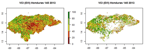 Map of Honduras showing the VCI without clouds (left) and without clouds (right). | ||