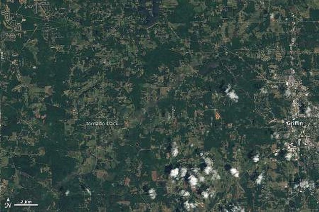
Tornado tracks from last week's powerful oubreak of events in the southern USA are visible in data from NASA's Aqua satellite and the Landsat satellite. A pale green swath in the above Landsat image from 28th April 2011 reveals the path of a tornado outside Griffin, Georgia, across lightly populated farmland. Bright coloured spots are buildings, some close to the path of the storm.
The town of Griffin, shown on the far right, is the nearest community to the storm track in this area. Credit: NASA , Jesse Allen and Robert Simmon, using USGS Landsat data.
Among the more than 150 tornadoes reported on 27th and 28thApril 2011, was a rare EF-5 storm. Such a storm has the capacity to collapse a concrete building. The tornado hit Smithville, Mississippi, where it killed at least 14 people, and moved northeast nearly three miles toward the Alabama border. It is the first EF5 tornado to occur in Mississippi since 1966,according to the US National Weather Service.
An image captured by NASA's Aqua satellite shows the path of exposed ground left in the tornado’s wake. The trail left by the EF5 tornado in Mississippi is much shorter than a similar trail that cuts across northwestern Alabama. The National Weather Service rated this tornado at EF4, with winds around 175 miles per hour, said local news reports. The track was about 12 miles long, and the tornado caused more than 20 deaths.The large storm system that generated the tornadoes was thedeadliest to hit the United States since 1974.