ESA’s Earth Explorers have again shown how they are surpassing expectations. Designed to map soil moisture and ocean salinity, the versatile SMOS satellite has demonstrated that it can also offer unique information to improve hurricane forecasts.
The Soil Moisture and Ocean Salinity (SMOS) satellite carries a novel microwave radiometer to capture images of ‘brightness temperature’. These images correspond to radiation emitted from the surface of Earth and can be used to work out how much water is held in soil and how much salt is in the surface waters of the oceans. This information is leading to a better understanding of the water cycle and the processes that link Earth’s surface and atmosphere. The SMOS sensor works in the ‘L-band’, at frequencies around 1.4 GHz, which also allows surface wind speeds over oceans to be derived, even in cloudy and rainy conditions. When winds reach gale force over oceans, breaking waves and whitecaps affect the microwave radiation being emitted from the surface. This means that when a storm builds, changes in the emitted radiation can be linked directly to the strength of the wind over the sea. In addition, the radiation detected by SMOS is far less disturbed by rain and atmospheric effects than higher microwave frequencies. Since clouds and rain are typical of tropical cyclones, measurements from SMOS uniquely complement observations made in extreme conditions, when measurements from other satellites become less accurate. This means that SMOS has the potential to improve accuracy for forecasting the strength of tropical cyclones.
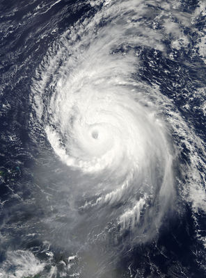
SMOS’s new-found capability was demonstrated by analysing SMOS data over Hurricane Igor, which reached category 5 in the North Atlantic in 2010. The large swath and frequent revisits allowed the satellite to pass over the hurricane nine times during 11–19 September. Surface wind speeds were estimated from SMOS brightness temperature images using a technique developed by scientists from the French Research Institute for Exploration of the Sea, Ifremer, and Collect Localisation Satellites, CLS, through ESA’s Earth Observation Support to Science Element programme. The animation at the top shows the result of their work. The estimates of surface-wind speed agree with hurricane model forecasts and data taken over the hurricane by NOAA aircraft. This information can be particularly useful in the early stages of developing hurricanes in the east of the tropical Atlantic basin and over cyclones in the middle of the Pacific. Since these areas are far from land, they are difficult to reach by plane. The contributions that SMOS can make are of great interest for operational forecasting of hurricane strength.
SMOS has also achieved another success: it has shown that salinity in the surface waters change in the wake of a hurricane. This is the first time that such changes have been detected from space. As the animation to the left shows, Hurricane Igor caused the freshwater plume from the Amazon to mix with deeper saltier waters, increasing the salinity at the surface. The combination of salinity data from SMOS with sea-surface temperature and sea-surface height information will improve the monitoring of fresh and warm water in relation to hurricane intensity. Although ESA’s Earth Explorers are developed to address specific scientific issues, they continue to demonstrate their versatility and complementary role, not only in advancing our understanding of Earth , but also their potential for everyday applications.