• English
  • Español
  • Français

United
Nations


Office for Outer Space Affairs
UN-SPIDER Knowledge Portal

  • Home
  • About Us
    • What is UN-SPIDER?
    • About UNOOSA
    • Publications
    • Jobs
    • Meet the Team
    • Contact
  • Space Application
    • Satellite Technology
    • Emergency Mechanisms
    • Recovery Mechanisms
    • International Asteroid Warning Network
    • Space Mission Planning Advisory Group
    • International Space Weather Initiative
    • Space Technologies in the UN
    • User Stories
  • Links & Resources
    • Data Applications
      • Disaster Recovery
    • Data Sources
    • GIS and Remote Sensing Software
    • Online Learning Resources
    • Institutions
  • Risks & Disasters
    • Disaster Risk Management
    • Early Warning Systems
    • Emergency and Disaster Management
    • Natural Hazards
    • Sendai Framework
    • The UN and Disaster Risk Management
    • The UN and Early Warning
    • The UN and Disaster Management
  • Advisory Support
    • Advisory Missions
    • Emergency Support
    • Virtual Advisory Support
    • Recommended Practices
    • Training Activities
    • Practical Uses
  • Network
    • Regional Support Offices
    • GP-STAR
    • MHEWS
    • IWG-SEM
  • Projects
    • SPEAR
    • SEWS-D
    • EvIDENz
    • Flood GUIDE
    • CommonSpace Initiative
    • Tonga Pilot Project
  • News & Events
    • News
    • Events Calendar
    • UN-SPIDER Events Archive

Breadcrumb

  • Home
  • News and Events
  • View Active News
  • Satellite Imagery To Compare Extreme Rainfalls Events From The Last Year In Sri Lanka
  • Satellite imagery to compare extreme rainfalls events from the last year in Sri Lanka

Satellite imagery to compare extreme rainfalls events from the last year in Sri Lanka

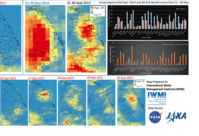
Accumulated rainfall September 2014 and 2015; and Rainfall events from 21 – 30 SeptAccumulated rainfall September 2014 and 2015; and Rainfall events from 21 – 30 Sept

The International Water Management Institute (IWMI) released some imagery from the satellite rainfall estimates for the current flood disasters in Sri Lanka. The Global Precipitation Mission (GPM) and Tropical Rainfall Measuring Mission (TRMM) revealed that the extraordinary flooding in Sri Lanka was caused by unusually strong monsoonal rainfall over the period between 10 September and 30 September 2014.

Massive flooding was reported mainly in the Southern, North central and Uva Province of Sri Lanka. The accumulated rainfall almost tripled in comparison to the rainfall in the same period last year.

Satellite imagery helps to map the affected areas, as well as to compare information of similar periods and analyze the different natural behaviors or disaster events. For instance, the southern provinces districts received an average of accumulated rainfall of more than 100mm from 24 to 30 September this year, while 75mm in 2014.


The Disaster Management Center (DMC) informed that nearly 19 000 people have been affected because of the extreme weather conditions in the south of the country. Satellite imagery also benefits local authorities for early warning and forecasting possible new events.
Thu, 1 Oct 2015 - 22:37
Asia Pacific
International Water Management Institute (IWMI)

Footer menu

  • Contact
  • Terms of Use

User account menu

  • Log in