• English
  • Español
  • Français

United
Nations


Office for Outer Space Affairs
UN-SPIDER Knowledge Portal

  • Home
  • About Us
    • What is UN-SPIDER?
    • About UNOOSA
    • Publications
    • Jobs
    • Meet the Team
    • Contact
  • Space Application
    • Satellite Technology
    • Emergency Mechanisms
    • Recovery Mechanisms
    • International Asteroid Warning Network
    • Space Mission Planning Advisory Group
    • International Space Weather Initiative
    • Space Technologies in the UN
    • User Stories
  • Links & Resources
    • Data Applications
      • Disaster Recovery
    • Data Sources
    • GIS and Remote Sensing Software
    • Online Learning Resources
    • Institutions
  • Risks & Disasters
    • Disaster Risk Management
    • Early Warning Systems
    • Emergency and Disaster Management
    • Natural Hazards
    • Sendai Framework
    • The UN and Disaster Risk Management
    • The UN and Early Warning
    • The UN and Disaster Management
  • Advisory Support
    • Advisory Missions
    • Emergency Support
    • Virtual Advisory Support
    • Recommended Practices
    • Training Activities
    • Practical Uses
  • Network
    • Regional Support Offices
    • GP-STAR
    • MHEWS
    • IWG-SEM
  • Projects
    • SPEAR
    • SEWS-D
    • EvIDENz
    • Flood GUIDE
  • News & Events
    • News
    • Events Calendar
    • UN-SPIDER Events Archive

Breadcrumb

  • Home
  • News and Events
  • View Active News
  • NASA Satellites Show Towering Thunderstorms In Rare Sub-tropical Storm Arani
  • NASA Satellites Show Towering Thunderstorms in Rare Sub-tropical Storm Arani

NASA Satellites Show Towering Thunderstorms in Rare Sub-tropical Storm Arani

Source: NASA Imagery

NASA's Aqua and TRMM satellites are providing data to scientists about the Southern Atlantic Ocean Sub-tropical Storm Arani, a rare occurrence in the southern ocean. Rainfall data and cloud top temperatures revealed some heavy rain and strong thunderstorms exist in Arani as it continues to pull away from Brazil.

On March 15 at 1820 UTC (2:20 p.m. EST) NASA's Tropical Rainfall Measuring Mission (TRMM) satellite flew over Sub-Tropical Storm Arani. TRMM rainfall data showed that the storm contained mostly moderate rainfall, falling at a rate between 20 and 40 millimeters per hour. On March,16 another of NASA's fleet of Earth science satellites flew over Sub-tropical Storm Arani and took its temperature. Later on March 16, at 10:52 UTC , the TRMM satellite again passed over Sub-Tropical Storm Arani and noticed it still had some strong thunderstorms and was producing heavy rainfall off the Brazilian coast.

TRMM data was used to create a 3-D view of Sub-tropical Storm Arani's clouds, and it showed that there were very heavy thunderstorms in the eastern half of the storm. TRMM's Precipitation Radar showed that some of these powerful storms were reaching to heights of over 14 km (~8.7 miles) above the surface of the Southern Atlantic Ocean.

Arani has the appearance of a tropical cyclone but has been classified as a subtropical cyclone. Subtropical cyclones are low pressure areas that develop with a cold core and transition to a warm core in the mid-levels of the troposphere, resembling a tropical cyclone. They more typically form outside of hurricane season.
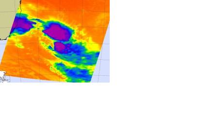


NASA on March 16, 2011
Thu, 17 Mar 2011 - 12:28

Footer menu

  • Contact
  • Terms of Use

User account menu

  • Log in