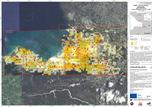
Following the devastating earthquake on Haiti, relief organisations require rapid, reliable and meaningful information on the local situation, the state of the infrastructure and the extent of the damage for their deployment in the disaster zone. In this context, scientists from the German Aerospace Center (Deutsches Zentrum für Luft- und Raumfahrt; DLR) are giving important support by providing free access to maps of the crisis region based on satellite data. At the moment, the researchers are focusing particularly on Port-au-Prince, the capital of the Caribbean island state, which has been particularly badly affected.
Under the 'International Charter on Space and Major Disasters' , ZKI (Center for Satellite Based Crisis Information; ZKI is a part of DLR, under the umbrella of the German Remote Sensing Data Centre in Oberpfaffenhofen ) makes available satellite data, particularly those from the TerraSAR-X satellite developed and operated by DLR, in crisis situations in Germany and worldwide, analyses satellite data and performs additional functions such as those of the coordinating project manager.
Source: German Aerospace Center
For full article please visit: www.dlr.de/en/desktopdefault.aspx/tabid-1/86_read-22076/