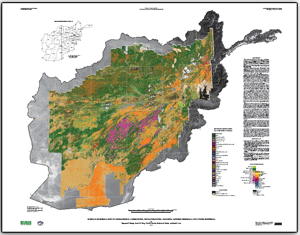
For the first time, about 70 percent of a country has been mapped using an advanced remote sensing technique known as hyperspectral imaging. In order to assist Afghanistan in understanding their abundant natural resources, in particular the development of an economically viable minerals market, the U.S. Geological Survey and the Department of Defense Task Force for Business and Stability Operations led an effort to fully map Afghanistan with hyperspectral data.
Airborne hyperspectral sensors measure light reflected from the earth. The spectrum of the reflected light can be interpreted to identify the composition of materials at the surface, such as minerals, man-made materials, snow, and vegetation. These materials can be identified remotely due to their unique light spectra. In addition, these data allow large geographic areas to be mapped quickly and accurately, showing mineral resources, natural hazards, agricultural conditions and infrastructure development.
The maps are available online.