Jen Ziemke can't feed the needy in Libya. But, like many academics, the political scientist in Cleveland can pitch in on relief efforts with a different skill: map making. And as agencies look to exploit new-media tools during crises, they're turning to volunteers like her for help.
Many academics are eager to lend a hand—or crunch a data set—for the cause. Their efforts are helping to turn the crises in the Middle East and Japan into an experiment in Disaster Relief 2.0. The result: a range of Web-mapping projects that are changing how crisis information is shared.
For map creators, the hope is that those tools will help relief workers on the ground. But academics building the platforms also have other audiences in mind: scholars who will study the crises, students eager for practical experience, and average citizens interested in getting breaking news stories in new ways.
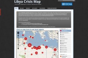
Much interest in large-scale, crowd-sourced crisis mapping grew out of the devastating earthquake in Haiti last year. Volunteers used handheld GPS devices to build up-to-date maps to assist relief workers in navigating the country. Humanitarian workers turned to crowdsourcing for information. They used online maps that collected text messages from people reporting trapped victims and medical emergencies. One mapping platform that gained particular attention was Ushaidi, which had earlier been used to report post-election violence in Kenya.