![]()
United
Nations
Earthquake
 Earth Observation Center (EOC) using data acquired by Sentinel-1A before and after the earthquake event. Image: DLR/EOC")
Definition
Facts and figures
Further information
UN-SPIDER Regional Support Offices with hazard-specific expertise
Related content on the Knowledge Portal
, processed by Planetek Rheticus Service.")
In September 2018, the Indonesian island of Sulawesi was hit by a 7.5 magnitude earthquake. The impact, combined with the tsunami, landslides, and soil liquefaction that followed, “... claimed well over 2000 lives, destroyed homes, buildings, infrastructure and farmland in several districts,” according to the European Space Agency (ESA).
Ten months later, response efforts are now moving into the recovery and rebuilding phase, with satellite information offering important insights to local officials. For example, through a collaboration with the Asian Development Bank, ESA is providing Indonesian officials with hazard-mapping tools derived from Earth observation data, and training in how to most effectively use these resources. “The main purpose of sharing these information products is to help the…
read more06/08/2019
In the past year, “there were 315 natural disaster events recorded with 11,804 deaths, over 68 million people affected, and US$131.7 billion in economic losses around the world.” This is according to the Centre for Research on the Epidemiology of Disasters (CRED) in its recently released 2018 Natural Disasters Report.
While these 2018 natural disaster values represent a decrease when compared with the annual averages from 2008 to 2017, some geographic areas still experienced great losses of life and damages due to natural hazards. Indonesia was most adversely impacted in terms of lives claimed, with earthquakes in August and September 2018 that left a total of 4,904 people dead or missing, according to the CRED. Earthquakes also accounted for the greatest number of deaths among natural disasters worldwide in 2018. And among all types of natural hazards, floods affected the greatest number of people during the…
read more01/07/2019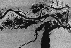 Publishing institution:
, EMSN024, EMSN056)")
To meet the global challenges, the United Nations adopted several framework agreements, including the Sendai Framework for Disaster Risk Reduction at the Third United Nations World Conference on Disaster Risk Reduction (2015-2030). The framework builds the international reference point for disaster preparedness and focuses on reducing existing and future disaster risks as well as enhancing disaster resilience. In the Sendai framework, seven global targets have been agreed to measure global progress in implementing the framework through quantifiable indicators and to present, compare and evaluate the status and progress uniformly worldwide. The recording of the status and degree of target achievement using the agreed indicators requires the use of various data sources, which must be consistent and comparable in time and space in order to ensure global monitoring.
Publishing institution: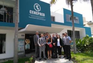 ,
,  ,
, 
As part of it advisory support activities, UN-SPIDER is carrying out out a Technical Advisory Mission (TAM) to Peru from 1 to 5 April to evaluate the current and potential use of space-based information in all aspects of disaster management. Based on exchanges with a wide range of stakeholders, UN-SPIDER will provide recommendations as to how to strengthen the use of space-based information in disaster risk management and emergency response in the country.
The team of experts led by UN-SPIDER is conducting multiple activities and institutional visits in Lima. The team is comprised of eight experts from UN-SPIDER; the German Aerospace Centre (DLR); the Argentinian National Space Activities Commission (CONAE); the Mexican Space Agency (AEM); the Agustin Codazzi Geographic Institute of Colombia (IGAC); the Santa Maria…
read moreRegional Support Offices mentioned:01/04/2019
The training date is in the past. However, videos and resources of the training can be accessed here.
According to the WHO, every year disasters “kill around 90,000 people and affect close to 160 million people worldwide.” This training will show participants how NASA remote sensing data can be used to characterize and monitor disaster-related events and support relief efforts. Each session will cover a different disaster and its supporting data. Disaster scenarios include tropical storms, flooding, earthquakes, and landslides.
Learning Objectives
By the end of this training, attendees will be able to:
-
Identify NASA data products to characterize and monitor the disasters, Tropical Storms, Flooding, Landslides and…
-
 to the plains in the south (right side). Vegetation appears red in this false-colour image, while waterways and buildings appear light green and blue. Image: ESA.")
On 12 March, Nepal Telecommunications Authority (NTA) signed an agreement with French satellite operator Thales Alenia Space to build Nepal’s first communications satellite. The Nepalese government intends to use the satellite to provide nationwide internet access to its citizens, improve disaster management efforts and strengthen economic growth in the country.
The development of Nepal’s own satellite system proves to be significant in terms of improving the country’s disaster management efforts. Nepal is regularly faces natural disasters such as droughts, floods, landslides, fires, and…
read more29/03/2019 ,
,  ,
,  ,
, 
As part of the technical advisory support it provides to countries worldwide, UN-SPIDER carried out an Institutional Strengthening Mission to Myanmar from 11 to 15 March 2019 upon the request of the government. This activity was jointly organized by UN-SPIDER and the United Nations Human Settlement Programme (UN-Habitat), under auspices of the Ministry of Social Welfare, Relief and Resettlement (MSWRR) of Myanmar. It was hosted by the Emergency Operation Centre (EOC). Experts from the Centre for Space Science and Technology Education in Asia and the Pacific (CSSTEAP), the International Centre for Integrated Mountain Development (ICIMOD) and Maxar contributed to the mission.
The mission was a follow-up activity to the UN-SPIDER Technical Advisory Mission (TAM…
read moreRegional Support Offices mentioned:19/03/2019
Earthquakes are a major concern in increasingly populated regions, however their prediction is a difficult task. Researchers have recently made progress in the use of complex simulation and modeling techniques to better forecast the occurrences of earthquakes.
In a recent study, researchers used Gradient Boosted Regression Trees, a machine learning technique for regression and classification problems that incorporates training data, to better determine spatiotemporally complex loading histories within subduction zones. The researchers simulated tens of earthquakes using a small‐scale experimental replica of a subduction zone and show that machine learning predicts well the timing and size of laboratory earthquakes by reconstructing and properly interpreting the spatiotemporally complex loading history of the system. These results promise substantial progress in real earthquake forecasting as they suggest that the complex motion recorded by geodesists at…
read more13/03/2019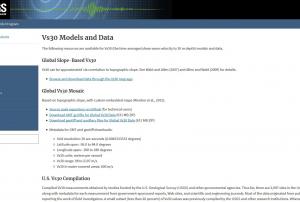 Compiled Vs30 measurements obtained by studies funded by the U.S. Geological Survey (USGS) and other governmental agencies. Thus far, there are 2,997 sites in the United States, along with metadata for each measurement from government-sponsored reports, Web sites, and scientific and engineering journals. Most of the data originated from publications directly reporting the work of field investigators. A small subset (less than 20 percent) of Vs30 values was previously compiled by the USGS and other research institutions. Whenever possible, Vs30 originating from these earlier compilations were crosschecked against published reports.
Both downhole and surface-based Vs30 estimates are represented. Most of the VS30 data are for sites in the western contiguous United States (2,141 sites), whereas 786 Vs30 values are for sites in the Central and Eastern United States; 70 values are for sites in other parts of the United States, including Alaska (15 sites), Hawaii (30 sites),…Publishing institution:
Term Parents
UN-SPIDER Regional Support Offices with hazard-specific expertise
![]()