Senegal has taken a significant step in its journey towards technological sovereignty with the successful launch of its first satellite, Gaindesat-1A. The earth observation nanosatellite was launched on 16 August 2024, from California's Vandenberg Space Force Base.
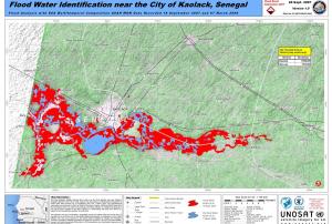
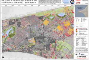
Developed by Senegalese engineers in collaboration with the University Space Centre of Montpellier (CSUM), Gaindesat-1A will play a crucial role in monitoring environmental conditions across the country. It will provide valuable data to improve water resource management, enhance weather forecasting, and boost aviation safety.
The launch is a major milestone for Senegal, marking the culmination of five years of dedicated effort by local engineers and technicians. The satellite's successful deployment represents the first phase of the SENSAT program, which aims to harness space technology for Senegal's socio-economic growth and scientific advancement.
This achievement positions Senegal as a key…
more aims to improve the use of satellite navigation in Africa, particularly with regards to air transportation (Image: NASA)")