Canada

country taxonomy block

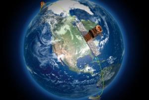
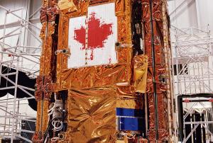
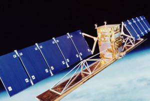
On 12 June 2019, a trio of identical Canadian Earth observation satellites, which will help monitor climate change and save lives during natural disasters, among other applications, were successfully launched into space from a SpaceX Falcon 9 rocket.  

The satellites, collectively referred to as the RADARSAT Constellation Mission (RAM), follow the legacy of over two decades of Canadian RADARSAT satellites that have provided important insights about the Earth’s surface. RAM builds upon this foundation and will provide increased information for researchers to better understand our planet. According to a news release from the Canadian Space Agency, “The constellation of three satellites will provide daily images of…

more
Publishing date 21/06/2019

The Canadian Space Agency and the Canada Centre for Mapping and Earth Observation have released 36,500 RADARSAT-1 images, which are available at no cost on the Government of Canada’s Earth Observation Data Management System. Having aided relief operations in 244 disaster events through the images it captured, the Canadian RADARSAT-1 satellite now has the opportunity to reach a broad pool of researchers, industry members, and the general public with its photos of the Earth’s surface.  

Launched in November 1995, RADARSAT-1 was Canada’s first Earth…

more
Publishing date 27/05/2019

Airbus Defence and Space and the Canada Centre for Mapping and Earth Observation (CCMEO) have signed a contract that enables the Canadian government and institutions to access imagery captured by the TerraSAR-X and TanDEM-X satellites for carrying out research and professional training without charges.

The objective of the partnership is to support Canadian agencies in the development of operational monitoring concepts by employing Canada’s C-Band radar mission in conjunction with the European X-Band satellites for maritime surveillance, disaster management and environmental monitoring. It focuses on an academic context that could enhance research and education.

TerraSAR-X and TanDEM-X Earth Observation twin satellites were developed by the German Aerospace centre (DLR) together with EADS…

more
Publishing date 07/08/2015

The Canadian company UrtheCast announced its plans to develop a constellation of brand-new Earth Observation satellites. Comprised of a minimum of 16 satellites, it will be the world’s first fully-integrated, multispectral optical and Synthetic Aperture Radar (SAR) commercial constellation of Earth Observation satellites. It is scheduled for launch between 2019 and 2020.

This new constellation will feature onboard real-time processing, cross-cueing between satellites, optical and SAR data fusion and real time cloud imaging.

UrtheCast is partnering with Surrey Satellite Technology (SSTL) from the UK and the Spanish ElecnorDeimos Space. According to UrtheCast’s President and COO, Wade Larson, “We’ve been working on the Constellation for over a year now and we’re delighted by the market reception we’ve had. We’re confident that the Constellation will bring an entirely unique dataset to this industry and, frankly, given the response…

more
Publishing date 23/06/2015

Researchers will have easier access to Landsat 8 satellite imagery thanks to a new tool made available by Blackbridge Networks and Cybera.

Canadian non-profit organisations such as academic institutions or research networks using geospatial information will be able to access thousands of Landsat 8 Level 1T terrain-corrected, multi-spectral images that are immediately available for selected regions of Canada, the United States, Brazil, Australia, and Western Europe. 

The catalogue of Landsat 8 imagery can be accessed via BlackBridge’s self-service Representational State Transfer Application Programming Interface (REST API), a tool built to help discovering and accessing large satellite imagery catalogues. Cybera provides a high-speed, unmetered research and education network infrastructure allowing the existence of this tool.

“It takes a lot of resources to accurately study and map Canada’s landscape, and geospatial researchers often devote…

more
Publishing date 21/05/2015

NASA is working together with Agriculture and Agri-Food Canada (AAFC) and its real-time In-situ Soil Monitoring for Agriculture network (RISMA) to improve and prepare information about the consistency of soil.

RISMA is a network of 22 soil monitoring stations in annually cropped fields to provide soil moisture, soil temperature and meteorological data and capture conditions for the main agricultural crop types, soil textures and eco-zones in Canada. This ground-based information will be to assess data coming from NASA’s satellite Soil Mositure Active Passive (SMAP) and test soil moisture mapping products.

”Those measurements in near real-time help us test new sensor technology, support our satellite-based soil research and model development, and allow us to collaborate with other science organisations. Monitoring soil moisture will enable the sector to better mitigate agricultural risks on a regional and national basis,”…

more
Publishing date 06/05/2015

Satellite-based maps have shown northern boreal forests suffered significant tree cover loss in 2013, especially in Russia and Canada. The high-resolution maps have been released by Global Forest Watch, a partnership led by the World Resources Institute.

“This new data shows in detail how Russia and Canada have faced a massive spike in tree cover loss. These forests and soils contain vast carbon stocks so losses represent a significant contribution to the greenhouse gas emissions that are driving climate change,” said Dr. Nigel Sizer, Global Director of WRI's Forests Program.

From 2011 to 2013, the tree cover loss of Russia and Canada represented a 34 percent at global level, with a combined average loss of 6.8 million hectares each year.

Russia and Canada were the two countries with highest average annual tree cover loss from 2011 to 2013, followed by Brazil, United States and Indonesia. Fires were the main cause for this development.

more
Publishing date 09/04/2015

The Canadian Space Agency CSA will invest 3.3 million CAD in the first worldwide survey of surface water. A Canadian company will develop an "Extended Interaction Klystron (EIK), a satellite radar component that will generate pulses used to gather surface information," the Government of Canada explained in a press release.

The press release continues: "The Surface Water and Ocean Topography (SWOT) mission will survey 90 percent of the globe, studying the Earth's lakes, rivers, reservoirs and oceans. SWOT data could lead to improvements in many water-related services in Canada, including operations at sea and water management systems, and will provide measurements for lakes and rivers in Northern Canada for which none currently exist."

more
Publishing date 01/09/2014

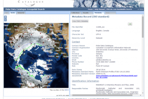
The Canadian Space Agency CSA in partnership with MacDonald, Dettwiler and Associates Ltd. MDA, and the Canadian Cryospheric Information Network (CCIN) at UWaterloo, have made public a mosaic of over 3,150 images collected by the RADARSAT-2 satellite. The images were captured with the Synthetic Aperture Radar aboard RADARSAT-2 in 2008 covering all of Antarctica. 

The mosaic is now freely accessible to the public. “The mosaic provides an update on the ever-changing ice cover in this area that will be of great interest to climatologists, geologists, biologists and oceanographers,” said Professor Ellsworth LeDrew, director of the CCIN and a professor in the Faculty of Environment at Waterloo.

“The Polar Data Catalogue’s mandate is to make such information freely available to scientists, students and the…

more
Publishing date 19/08/2014

After issuing a Request for Proposals (RFPs) in February 2014, the Canadian Space Agency’s (CSA) Earth Observation Application Development Program has awarded twelve new contracts to GHGSat, Kepler Space, and Macdonald Dettwiler and Associates (MDA) and other Canadianc companies totaling of $6.7 million in order to develop new products from CSA’s Radarsat 2 and Earth Observation (EO) satellites.

“The investments announced today will help provide important information so we can better understand our planet while creating jobs and contributing to the growth of Canada’s reputable space industry,” said James Moore, Canada’s minister of industry.

The CSA aims to develop new products applying satellite radar data toward environmental uses such as agriculture, forest industry and wetland studies as well as improving responses to natural disasters, monitoring land resource use and ice formation.

more
Publishing date 11/08/2014

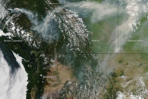
The Moderate Resolution Imaging Spectroradiometer (MODIS) on NASA’s Aqua satellite captured dozens of wildfires in Canada and the northwestern United States. Actively burning areas, detected by the thermal bands on MODIS, are outlined in red. Forests appear dark green.

NASA reported: "According to the Canadian government, 102 uncontrolled fires were burning in British Columbia on July 17, and there were 13 more in Alberta. Across the border, 33 uncontrolled fires were active in Washington and Oregon." On the image to the left "the snow-capped peaks of the Canadian Rockies are visible in the center of the image. Large banks of white clouds hover over the Pacific Ocean, northern Alberta, and Wyoming. Winds pushed long plumes of smoke east toward Alberta and into Saskatchewan."

Publishing date 22/07/2014

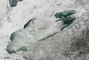
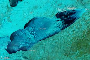
The Moderate Resolution Imaging Spectroradiometer (MODIS) on NASA’s Aqua satellite acquired these images on January 9, 2014. The extreme cold weather that paralyzed North America early this year brought thick ice over the Great Lakes in Canada.

The top image shows Lake Erie in natural color, the second one shows a blend of shortwave infrared, near infrared and red that help distinguish ice from water. Ice is pale blue, the thicker the brighter, open water is navy, and snow is green.

Though ice covers the Lakes every year, news reports says that this year the ice cover was thicker and wider spread than it has been in nearly two decades. This caused disturbance in ship traffic in the region.

On January 9, nearly 90% of Lake Erie was covered with ice. Ironically, the ice cap on top of the lakes stifled the persistent “lake effect” snowstorms that had buried Buffalo, New York, and other towns during the deep freeze of early January. Cold arctic winds blowing across…

more
Publishing date 16/01/2014

The European Earth Observation Services Industry is steadily growing. This is the main outcome of the report "A Survey into the State and Health of the European EO Services Industry"- The report was prepared and published under assignment from the European Space Agency (ESA) by the EARSC (European Association of Remote Sensing Companies) and it covered all companies fo whom satellite derived EO data is part of their business.

The report states: "There has been a steady growth in the turnover of the sector since the previous survey in 2006 accompanied by a good growth of employment. The sector has seen a lot of change. The period has seen the launch of a number of new commercial satellite systems (see section 2) as well as significant technology change with the development of Google Earth, the advent of cloud computing and a move towards crowd sourcing. These and other technologies such as Remotely Piloted Aircraft systems are arriving on the horizon and maybe…

more
Publishing date 23/09/2013

The efforts of Natural Resources Canada for improving and increasing web accessibility have resulted in the decision of moving the NEODF-Cat web presence to a new web portal known as the National Earth Observation Data Framework Catalogue (NEODF-Cat) on 1 August 2013. The so-called NEODF Catalogue is a key element for the correct functioning of the National Earth Observation Data Framework (NEODF), a prototype system that illustrates a new approach to improving access to Earth Observation (EO) data and products.

The NEODF-Cat helps the National Earth Observation Data Framework on fulfilling its two main goals: preserve and make available in a timely manner all valuable EO assets purchased by the Government of Canada; and to manifest the potential benefits resulted from integrating decision-support tools to help users search and select in a way that best meets their needs.

The new NEODF-Cat website is…

more
Publishing date 02/08/2013

The International Space Station (ISS) partner agencies released a common statement on 17 July 2013 underlining the benefits of the space station during disasters caused by natural hazards on Earth. The ISS partner agencies US National Aeronautics and Space Administration, Canadian Space Agency, European Space Agency, Russian Federal Space Agency and Japan Aerospace Exploration Agency stated "The ISS Partners are committed to continuing to share this unique asset in space and the benefits it brings to life on Earth."

The International Space Station (ISS) is a global research facility primary focused on Earth observation. "A unique complement of automated and crew-operated Earth observation assets are on board the ISS" the statement informs, "in addition, the orbit of the ISS provides a distinct perspective over Earth targets that augments polar-orbiting remote sensing spacecraft". Consequently, it is easy to imagine the…

more
Publishing date 22/07/2013

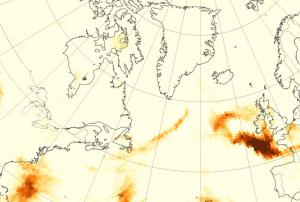
Satellite observations suggest fires in Quebec sent smoke billowing across the Atlantic; but pinpointing the source can pose a scientific challenge, as NASA points out in a recent web article.

Wildfire smoke is a combination of gases and aerosols—tiny solid and liquid particles suspended in air. The maps attached are made from data collected by the Ozone Mapper Profiler Suite (OMPS) on the Suomi National Polar-orbiting Partnership (Suomi-NPP) satellite. They show relative aerosol concentrations, with lower concentrations appearing in yellow and higher concentrations appearing in dark orange-brown. Areas in gray represent data that was not available.

On June 23, 2013, OMPS detected a plume dense with smoky aerosols over the North Atlantic Ocean, east of Newfoundland. The plume blew east on the 24th and reached France by June 25. While wildfires in Colorado may have contributed to the plume, a trajectory analysis by Alain Malo, a meteorologist from the…

more
Publishing date 11/07/2013

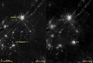
The International Charter: Space and Major Disasters was activated on 8 July 2013 to provide satellite imagery for the train derailment and consecutive oil spill and oil fire in Lac-Mégantic, Quebec, Canada. The mechanism was activated by Public Safety Canada.

An out-of-control driverless train containing 73 cars rolled into Lac-Mégantic at approximately 01:15 am ET on 06 July 2013, derailing in the centre of the town. The unit train was carrying petroleum crude oil, which exploded and decimated the surrounding area. Five people are confirmed dead, and around forty more are still missing. Fire officials have said that at least thirty buildings have been destroyed in the centre of the town. The full extent of the damage remains unknown and many residents have not been allowed back to their homes and businesses because of the safety risk.

NASA's Suomi NPP satellite also captured imagery of the affected area using Visible Infrared Imaging Radiometer Suite (…

more
Publishing date 09/07/2013

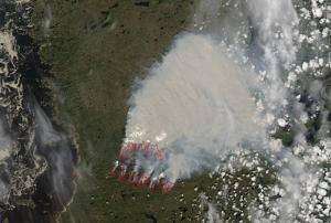
Satellites can easily detect what is not visible to the human eye. NASA's Aqua satellite acquired imagery of a large wildfire burning in Western Quebec on 19 June 2013, near the shoreline of Hudson Bay. By using its MODIS (Moderate Resolution Imaging Spectroradiometer), the satellite could detect hot spots with unusually warm surface temperatures associated with fire - indicated by the red outlines.

NASA regularly publishes satellite imagery on their MODIS Rapid Response Gallery. Both NASA's Terra and Aqua satellite are equipped with MODIS sensors. Terra's orbit around the Earth is timed so that it passes from north to south across the equator in the morning, while Aqua passes south to north over the equator in the afternoon. Terra MODIS and Aqua MODIS are viewing the entire Earth's surface every 1 to 2 days, acquiring data in 36 spectral bands, or…

more
Publishing date 21/06/2013

Having surpassed its expected lifespan by 12 years, on March 29, 2013, Canada's first Earth Observation satellite, RADARSAT-1, moved towards retirement due to a technical malfunction.

The Canadian Space Agency's (CSA) experts have put the spacecraft in "safe mode" - a semi-dormant state that conserves energy. The team will now investigate the anomaly, but has low expectations of a full recovery, as CSA stated.


RADARSAT-1 was launched in 1995 and was a great technological success for the Canadian space sector due to its long lifespan. RADARSAT-2 will continue to provide critical, high-quality data. Requests for RADARSAT-1 archieved imagery will continue to be processed, CSA stated on their website.

more
Publishing date 11/04/2013

The Canadian Space Agency has given out a seven-year contract for the construction of three new Radarsat satellites to be launched in 2018 and for the oversight of initial operations. The major component of surveillance will be covering Canadian territory and neighbouring property, notably monitoring of land and water in the Arctic. The $706-million contract was won by MacDonald Dettwiler and Associates Ltd. (MDA), one of Canada's radar leaders.

“In Canada, one of the keys is we need to take care of our vast country and our coastal zones in the North, and the way to do that is through radar surveillance,” MDA chief executive officer Daniel Friedmann said in an interview Wednesday from the company’s head office in Richmond, B.C. as reported The Globe and Mail. “You cannot keep an eye on Canada’s Arctic without radar. So if you don’t know what’s going on up there, you don’t own it and other people can do what they want.”

Publishing date 11/01/2013

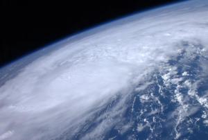
The Canadian Space Agency, in close cooperation with the Committee on Earth Observation Satellites (CEOS), continues to be a major contributor to the Caribbean Satellite Disaster Pilot (CSDP), which is GEO (Group on Earth Observations) project (GEO task DI-01-C5_1). During the 2012 Atlantic hurricane season RADARSAT-2 has captured some 70 high-resolution images to-date for rapid damage assessments over areas affected by hurricanes and severe tropical storms.

For the past three years RADARSAT-2 has proven a unique and valuable source of cloud-free and time-critical information for the CSDP partners in the Caribbean directly involved in hands-on national emergency management, research, and education. The Caribbean Disaster and Emergency Management Agency (CDEMA) and NASA play a coordinating role to ensure that the data collection and distribution is directed toward areas and organizations in need for timely geospatial information. Canadian RADARSAT-2 data sets for the CSDP…

more
Publishing date 17/10/2012

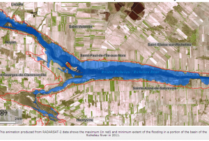
Within the framework of the international Committee on Satellite Earth Observation (CEOS), the Canadian Space Agency (CSA) is collaborating with NASA on various projects helping to prevent, manage and respond to natural disasters. During the spring flood along the Richelieu River in May 2011, CSA asked colleagues from NASA to acquire satellite images with the EO-1/ALI sensor in order to capture the flood extent. The ALI images complement an entire time series of RADARSAT-2 images acquired by the Canadian Government over the affected region, providing additional details thanks to the multi-spectral and pan-chromatic imaging capabilities of ALI.

Through the new Rapid Information Products and Services (RIPS) initiative, the CSA’s Earth Observation Applications and Utilizations (EOAU) Division, in close cooperation with Public Safety Canada (PS) and Effigis, developed flood maps and geo-information products derived from the RADARSAT-2 and EO-1/ALI data. A time series…

more
Publishing date 15/10/2012

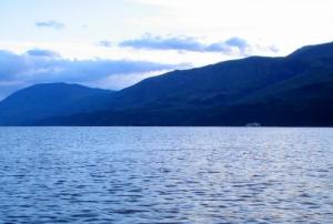
On Saturday, heavy rains fell in B.C's Shuswap region, where more than 340 people were ordered out of their homes into the community of Sicamous area in Vancouver, Canada. Canadian officials declared a state of emergency, issuing a water-conservation notice to some 3,100 residents on Shuswap Lake. A do-not-use water order has also been issued for one water system.

Since the flooding, at least 1,240 British Columbians faced flood-evacuation alerts and 165 others were under evacuation orders. A low pressure system dropped 60 - 80 millimetres of rain overnight in the area, almost three times more than expected within a month for this region. A few homes have been damaged, but most homes remain intact. A body of a 73 year old man has been found after being swept away into a fast moving creek on Saturday. Further flooding is expected over the next few weeks.

Publishing date 25/06/2012

Water isn't the only thing pouring over Niagara Falls. Pollution from fires in Ontario, Canada is also making the one thousand mile trip, while being measured by NASA's Aqua satellite. One instrument that flies aboard two of NASA's satellites has provided two views of the pollution from the fires in Ontario. The Moderate Resolution Imaging Spectroradiometer, or MODIS instrument, flies onboard NASA's Aqua and Terra satellites. MODIS has provided a visible look at the smoke and pollution that has spread over Niagara Falls and east to Nova Scotia.

As of July 20, the Canadian Interagency Forest Fire Centre (CIFFC) noted that Ontario accounted for 40% of the new fires in the entire country during the week of July 17. The CIFFC reported that so far in 2011, more than 300,000 hectares have burned in Ontario. The Nova Scotia Chronicle Herald reported that smoke from those fires also reached Nova Scotia and Newfoundland by the end of that week.

NASA's Aqua satellite passed…

more
Publishing date 01/08/2011

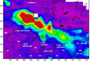
Fires throughout Ontario are generating pollution that is showing up in data from NASA's Aura Satellite in the Great Lakes region. The fires have also forced thousands of residents to evacuate to other areas in Canada, according to CBC News. About 112 fires have ravaged 81,545 acres so far, said the province's minister of natural resources, Linda Jeffrey. Because of the smoke from wildfires blowing south, the Minnesota Pollution Control Agency issued an air pollution alert, according to the Duluth News Tribune.

An image of the pollution from fires in Ontario was created from data of nitrogen dioxide (NO2) levels over the period from July 15, 2011 to July 18, 2011. It was created from Ozone Measuring Instrument (OMI) data using the NASA Giovanni system by Dr. James Acker at NASA's Goddard Space Flight Center in Greenbelt, Md.

NO2 forms during fires when nitrogen reacts with oxygen. In fact, NO2 is formed in any combustion process where the oxygen is provided by Earth's…

more
Publishing date 26/07/2011