Keita Mahamadou S., Deputy Executive Director, Regional Centre for Training in Aerospace Surveys (RECTAS), Ile-Ife, Nigeria
Abstract
Advances in space and information technologies have positively impacted on critical capacity globally through availability of geospatial information technology tools. To be fully utilised however, the space and information technologies must be understood by skilled manpower in Africa to tackle the major challenges in disaster management.
In Africa, the majority of the professionals and technicians in different organisations involved in geospatial information activities have not been making full use of data and tools to manage and alleviate the consequences of natural disasters due to low proficiency in the space technologies. Today there is increasing demands of well-trained staff at all levels, to face the main challenges of disaster management and emergency response. Therefore, it became necessary to provide training and capacity-building in the use of space- and information technologies for different levels of professionals involved in disaster management. This is for the benefit of communities affected by different kinds of hazards. It will involve exchanges and communication between experts and development partners on one hand, and experts and local communities who must also understand and value the use of space technologies to solve their problems, on the other hand.
This paper examines the constraints for manpower development in space- and geo-information technology to tackle numerous disasters occurring in Africa (flood, drought, windstorm, wild fire, famine, epidemic, etc...). The role of capacity-building by training institutions like the Regional Centre for Training in Aerospace Surveys (RECTAS), Ile-Ife, Nigeria in improving the situation and facing the main challenges is emphasized and case studies presented.
Introduction
The impact of natural disasters on the global environment has become increasingly severe over the last decades. The reported number of disasters has risen dramatically, as well as the number of people affected and the cost to global economy. About 95% of the deaths due to disasters occur in developing countries. (Kufoniyi, 2007). While natural disasters have drastically increased in magnitude and frequency, the possibilities of improving the technical capability to mitigate them have also dramatically increased.
Through the current initiatives in and outside Africa, it can be observed that the future orientation of space- and geo-information activities is that they must be available for people who need them for various applications and decision making. The advances in space technology (specifically earth observation satellite technology), with high spectral resolution data has increased the potential of these tools in all scientific and social areas. In disaster management, space-based technologies are used to monitor the environmental situation at certain intervals and to carry out risk analysis by combining the data with detailed local knowledge about the area in combination with geographic information. Therefore, there is a need for pro-active capacity development in all aspects of earth observation and geo-information production, management and use in Africa in order to address the huge capacity gaps. It will require the development of a critical mass of skilled human resources, organisational reforms, technological capacity and institutional strengthening.
The paper presents some important aspects of capacity-building in earth observation and geo-information science that are essential to overcome the challenges of disaster mitigation and emergency response. Recent developments and initiatives are presented. The role and contributions of RECTAS, a regional training-- and research institution in West-Africa, are also highlighted. Recommendations are then advanced to face the challenges of man-power development for disaster management in Africa.
Capacity-building in Earth Observation (EO) and geo-information science
Capacity-building encompasses improvement in the country’s human, scientific, technological, organizational, institutional and resource capabilities. A fundamental goal of capacity-building is to enhance the ability to evaluate and address the crucial questions related to policy choices and modes of implementation among development options, based on an understanding of environment potentials and limits and of needs perceived by the people of the country concerned. (Ayeni, 2008).
The components of capacity-building
The main components of capacity-building are the following:
- Human resource development, the process of equipping individuals with the understanding, skills and access to information, knowledge and training that enable them to perform effectively;
- Organizational development, the elaboration of management structures, processes and procedures, not only within organizations but also the management of relationships between the different organizations and sectors (public, private and community);
- Institutional and legal framework development, making legal and regulatory changes to enable organizations, institutions and agencies at all levels and in all sectors to enhance their capacities.
Capacity-building for the production, management, dissemination and use of geo-information is therefore of immense importance, which requires focused and concerted efforts towards strengthening of national and regional capacity-building institutions including harmonization of methods and concepts.
In the context of human capacity-building, three major groups have been identified as having critical needs of geo-information capabilities:
- Experts in the field of spatial information handling (or specialists in certain aspects of this field);
- Users of space-based technology and geo-information and
- Professionals and policy makers (to enable them to know the importance of geo-information for policy formulation).
Role of capacity-building in disaster management
Training and capacity-building in Earth Observation and Geo-information Science for disaster management / disaster risk reduction will help the experts and stakeholders in the following areas:
- Understand the hazard (where and when and why it is likely to occur);
- Know which areas and communities are most vulnerable to hazards, and what capacities and capabilities are available to cope with disasters;
- Develop knowledge and information resources to enable the risks to be better identified and potential impacts to be adequately assessed;
- Ensure political commitment to disaster risk reduction at various levels, through policy development, legislation, organizational development and promoting community action',
- Increase education and raise awareness of the risks and motivate for changes in collective behavior to reduce risks;
- Understand and take action to mitigate or relieve the socio-economic conditions that create or increase the vulnerability of a community;
- Implement environmental management, physical and technical measures to reduce risks to communities;
- Increase the coping capacity of communities through better communication, improved resources, etc;
- Have a disaster preparedness plan in place. This plan should cover both emergency management and recovery from a disaster;
- Develop hazard monitoring systems and early warning indicators.
Current developments in space- and geo-information capacity requirements
Different issues and events have brought up the need for capacity development efforts in Africa. These include increasing interest of African countries in Space Science and Technology development, National Geospatial Data Infrastructures and National Disaster Management.
- In Space Science and Technology Development, African countries have been involved in the launch of their own earth observation satellites: AlSat-1 (2002) by Algeria and NigeriaSat-1 (2003) by Nigeria. In addition, there has been a significant increase in the awareness of decision makers and civil society in the applications of earth observation satellite data and Geographic Information Systems (GIS). It is essential to match these developments with the manpower development in the applications in disaster reduction and emergency responses (UNECA, 2010).
- In the area of Geospatial Data Infrastructure (GDI), the need for provision of skilled manpower, organisational capacity and institutional reforms has been recognised and is being pursued vigorously now. A good number of countries have already adopted their fundamental datasets and developed their National Spatial Data Infrastructures and Spatially Enabled Government Services with the support of the United Nations Economic Commission for Africa (UNECA) and other partners. To further underpin the importance of capacity-building, the National Geo-information Policies made provision for a training component for all projects, research on new innovations in geoinformatics and its various applications, training in Spatial Data Infrastructure (SDI) concepts, among others.
- In the area of Disaster Management, the strategies developed require to close the gaps for manpower capacity-building. An important role is being played by the United Nations Office for Outer Space Affairs (UNOOSA), through its UN-SPIDER Programme (United Nations Platform for Space-based Information for Disaster Management and Emergency Response) in building capacity and increasing the awareness in the use of space technology for disaster management and emergency response.
- African Geodetic Reference Frame (AFREF), the UNECA continues to work with partners to implement the AFREF programme. The activities include group meetings, workshops and capacity-building to adopt the correct methodologies for the future of AFREF.
RECTAS’ contributions
The Centre and its activities
The Regional Centre for Training in Aerospace Surveys (RECTAS) was established in 1972 under the auspices of the United Nations Economic Commission for Africa (UNECA) to undertake training and research in Geoinformation Science for the manpower needs of African nations. It is situated in the campus of the Obafemi Awolowo University (OAU), Ile-Ife, Nigeria. Currently, the participating member countries are Benin, Burkina Faso, Cameroon, Ghana, Mali, Niger, Nigeria and Senegal.
The main mission of the Centre is to contribute to rapid sustainable development of member states in particular and Africa in general, through the development of critical capacity for timely delivery and responsible use of appropriate geospatial information.
The objectives of the Centre are:
- To provide theoretical and practical training in the field of Geoinformatics, including in particular, photogrammetry, remote sensing, cartography, Geographic Information Systems (GIS) and their applications in geospatial surveys, environmental studies, mapping, natural resources management, etc.
- To conduct seminars, workshops and short courses with a view to providing an opportunity for dissemination of information in the field of Geoinformatics
- To carry out studies and research in the field of Geoinformatics and
- To provide advisory and consultancy services in Geoinformatics and other related areas
From inception in 1972 to date, the Centre has trained 1522 students from 28 African countries (Ikhuoria, 2010). RECTAS has conducted many studies and research, capacity-building and projects execution in different areas of specialisation including disaster management in the participating countries as well as in other countries in Africa. In collaboration with different institutions and partners, the following activities were undertaken:
- Refresher courses in Disaster Management, organised jointly by RECTAS/Nigeria and ITC/Netherlands;
- Short Term Training course in the use of Remote Sensing and GIS in Disaster Management for staff members of the National Emergency Management Agency (NEMA), Nigeria;
- Customised training in Remote Sensing and GIS for staff members of Nigerian Geological Survey Agency (NGSA);
- Customised training in Remote Sensing for staff members of National Space and Research and Development Agency (NASRDA);
- Customised training in GIS and Digital Cartography for Staff members of the National Population Commission (NPopC), Nigeria;
- Participation in UN-SPIDER technical assessment missions and workshops (Abuja, Vienna, Lome, Dakar, etc...);
- Contribution to the activities of the Marine Pollution Monitoring Project in Nigeria;
- Participation in ECOWAS Early Warning workshops in Accra (Ghana) and Dakar (Senegal);
- Organisation of AFREF Experts’ group meeting at RECTAS, Ile-Ife, Nigeria.
Case-studies on disaster management by RECTAS
The following show some case studies by students and staff of the RECTAS:
- Exploration of Remote Sensing and GIS Technology for early Warning in Bush Fire in Benin Republic;
- Use of GIS in Conflict and Crisis Management;
- Monitoring of Desertification in West Africa Using Remote Sensing and GIS techniques
- A GIS approach for prevention and management of flood in Cotonou / Benin Republic
- Identification of flooded areas in Sokoto state in Nigeria using recent Radarsat-2 data (September 2010) – This was undertaken following the flood that occurred in Sokoto state this year. A Radasat-2 scene was downloaded at RECTAS. The result shows the situation of the area viewed by Landsat ETM+ and overlay of flood areas identified with the interpretation of the Radarsat-2 image.
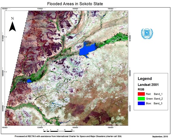
Figure 1: Landsat view of the area under investigation
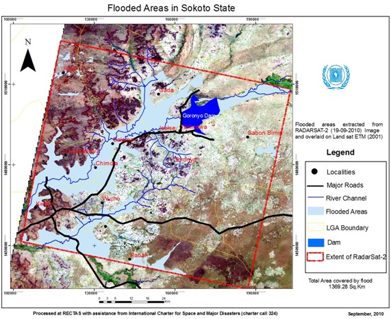
Figure 2: Flooded areas detected by Radarsat-2 (September 2010)
Conclusion and recommendations
This paper particularly emphasizes the use of remotely-sensed data and the access to space-based technology for assessing and monitoring natural hazards. Enhancing the skills in interpreting multi-temporal, multi-date and multi-sources input data has been considered as a priority for developing countries. The relevant data should be made available to communities for early warning and emergency response, mostly to those affected by the major and frequent disasters in Africa. African experts as well as the communities affected by the catastrophes are facing a lot of challenges, including the access to space-based information, human capacity-building, development of appropriate institutions, monitoring of parameters, etc.
However, the following recommendations are made in order to improve the situation and save the lives of people when possible:
- The importance of earth observation and geo-information in disaster management should be amplified.
- Synergies should be developed between technical/financial partners, experts and local communities to improve exchanges and communication.
- Disaster Risk Reduction Networks should be developed.
- Appropriate curriculum on the use of space technologies for disaster management should be developed for training institutions.
- Free or low-cost data can be used (such as ASTER, MODIS, Landsat ETM+, SRTM-DEM, AVHRR, etc.) in order to increase and ease the access to disaster-related data.
- Legal frames should be created to develop standards, monitor parameters and harmonise concepts.
Finally, it should be noted that the continuous capacity-building of experts and communities on a more careful planning for the location, type and durability of developments in and near hazard-prone areas, can definitely reduce losses and enhance the speed of recovery.
References
- Ikhuoria, Isi A., RECTAS: Strategies and Synergy of Accomplishing Objectives, Vision and Collaborative Research (2010).
- UNECA, Report on ECA’s Activities Since the 43rd Meeting of RECTAS Governing Council (2010).
- Bola Ayeni, Building the Capacity of Developing Countries in Disaster Risk Reduction and Management (2008).
- Olajide Kufoniyi, Improving Capacity Building in Earth Observation and Geo-Information Science in Africa through Educational Networking (2007).
Contact
Keita Mahamadou S.
keita [at] rectas.org, ded [at] rectas.org