• English
  • Español
  • Français

United
Nations


Office for Outer Space Affairs
UN-SPIDER Knowledge Portal

  • Home
  • About Us
    • What is UN-SPIDER?
    • About UNOOSA
    • Publications
    • Jobs
    • Meet the Team
    • Contact
  • Space Application
    • Satellite Technology
    • Emergency Mechanisms
    • Recovery Mechanisms
    • International Asteroid Warning Network
    • Space Mission Planning Advisory Group
    • International Space Weather Initiative
    • Space Technologies in the UN
    • User Stories
  • Links & Resources
    • Data Applications
      • Disaster Recovery
    • Data Sources
    • GIS and Remote Sensing Software
    • Online Learning Resources
    • Institutions
  • Risks & Disasters
    • Disaster Risk Management
    • Early Warning Systems
    • Emergency and Disaster Management
    • Natural Hazards
    • Sendai Framework
    • The UN and Disaster Risk Management
    • The UN and Early Warning
    • The UN and Disaster Management
  • Advisory Support
    • Advisory Missions
    • Emergency Support
    • Virtual Advisory Support
    • Recommended Practices
    • Training Activities
    • Practical Uses
  • Network
    • Regional Support Offices
    • GP-STAR
    • MHEWS
    • IWG-SEM
  • Projects
    • SPEAR
    • SEWS-D
    • EvIDENz
    • Flood GUIDE
  • News & Events
    • News
    • Events Calendar
    • UN-SPIDER Events Archive

Breadcrumb

  • Home
  • Advisory Support
  • Recommended Practices
  • Recommended Practice: Flood Mapping and Damage Assessment Using Sentinel-2 (S2) Optical Data
  • Recommended Practice: Flood Mapping and Damage Assessment using Sentinel-2 (S2) Optical Data

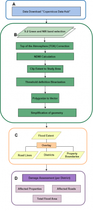
Flowchart

Recommended Practice: Flood Mapping and Damage Assessment using Sentinel-2 (S2) Optical Data

As a means of emergency response after a flooding event or inland inundation, flood mapping helps to estimate the extent of the flood on a large scale. It is a basis of coordinating appropriate recovery activities, rehabilitation and prevention measures for possible upcoming events. This UN-SPIDER Recommended Practice on flood mapping and damage assessment explains the use of Sentinel-2 (S2) optical satellite data from the European Space Agency (ESA), which acquires data in 13 spectral bands. It provides hands-on practice to calculate the Normalized Difference Water Index (NDWI) to determine the flood extent and it includes damage assessment.

Step-by-Step Flood Mapping and Damage Assessment using S2 Data
In Detail: Flood Mapping and Damage Assessment using S2 Data

The objective of this practice is to identify the extent of a flood as well as the affected infrastructure such as roads and settlements and impaired areas of interest for example agricultural regions. This information can be used by disaster management agencies and other stakeholders to undertake the rescue and relief activities in affected areas.

Flood
Recovery & Reconstruction
Relief & Response
Fitzroy River at Rockhampton, Queensland, Australia.

The practice developed by the “Space Application Centre for Response in Emergency and Disaster” of SUPARCO (Pakistan) was initially applied to the flood event in Punjab (Pakistan) in July 2015. Thereafter, it was used annually for river monitoring during monsoon season. The extraction of the flood extent was applied to the river Jhelum upstream of Trimmu Barrage, while the map generation covered the River Indus and its tributaries in Punjab, Pakistan.

For this Recommended Practice the methodology was applied to the Fitzroy River around the city of Rockhampton in Queensland, Australia. In April 2017, the central city of Queensland was inundated by flood waters. The water rose over several days until its peak that was captured by the processed satellite imagery from 8 April 2017.

Part A of this Recommended Practice can be applied to most flood events around the globe. The flood inundation is extracted from Sentinel-2 visible bands at 10 meters spatial resolution. The method can therefore only be applied for satellite scenes with little to no cloud cover.
Part B then maps and quantifies the flood affected and damaged areas and can be applied to all shapefiles that are being included in the analysis.

This recommended practice is applicable to Sentinel 2 data, for other data sources, such as those provided by Google Earth, you can find further information on Earth Lab by the University of Colorado.



Recommended by:

Related Practices

Recommended Practice: Flood Hazard Mapping
Recommended Practice: Radar-based Flood Mapping

Related data

Sentinel 2 - Imagery (ESA)

view all

Related Software

QGIS

view all

Disclaimer:

Neither UN-SPIDER nor the Regional Support Offices (RSOs) or their partners take any responsibility for the correctness of outputs from this recommended practice or decisions derived as a consequence.


Footer menu

  • Contact
  • Terms of Use

User account menu

  • Log in