
On Saturday, 25 April 2015 6:11UTC, an earthquake with a magnitude of 7.8 and a depth of 15km struck Nepal affecting 6.5 Million people within 100km (cf. GDACS). Several aftershocks have occured since then, notably a 6.6. magnitude aftershock about 30min after the initial earthquake and a 6.7 magnitude aftershock on Sunday 26 April 2015 at 7.09UTC (cf. JRC Situation report No.1).
On the 12th of May a magnitude 7.3 earthquake occurred with an epicenter close to Mount Everest, 18km South East of Kodari at 7:05:19 UTC (12.35 am local time) followed by a magnitude 6.3 earthquake at 7:36:53 UTC, 33km NNE of Ramechhap (cf. USGS). It occurred at a depth of 11.5 miles. A number of smaller aftershocks were recorded by the USGS. These aftershocks caused more buildings to collapse and landslides to occur.
To support the response to the disaster, several actors are involved in producing useful information. UN-SPIDER compiles this information here to make it easily accessible. This page is constantly being updated. If you are aware of additional information, please contact the UN-SPIDER team at un-spider [at] unoosa.org and we will include it in the list.
Last Update: 22/05/2015 9.59am gmt
Content:
Satellite-based Emergency Mapping
Satellite-based risk and pre-event information
Direct links to the maps and data
Needs and Areas of Interest
- There is a report of over 100 people stranded in Gauri Shankar VDC of Dolokha district. They have requested organizations to check the coordinates 27.8707N; 86.4635E to see if there is anything close to that location.
- Following the most recent aftershocks on the 12th of May, Dolokha, Sindhupalchowk, Gorkha, Rasua and Ramechhap districts have suffered extensive damage. A major concern is the status of glacial lakes and landslide dammed lakes.
- With monsoon season approaching there are concerns about potential flooding and risks to spontaneous IDP camps. Once monsoon rains begin, access to high-lying and remote areas will be seriously curtailed.
- Humanity Road's latest Situation Report (May 12th, 2015) can be found here. It details relevant help lines, reunification sites and the status of roads and hospitals in Nepal. It also reports on the districts that have been affected by the latest aftershock and casualties.
- The World Food Programme Nepal Situation Report #7 (May 18th, 2015), and UNOCHA report #16 (May 18th, 2015) give further details on needs and areas of interest.
- The Humanitarian Open Street Map Team (HOT OSM) has identified areas that need high resolution imagery for both base mapping and damage assessment. The team stresses the urgent need for cloud free imagery directly north of the Kathmandu valley, as these areas are still cut off from any relief/aid. Areas requested by HOT OSM are highlighted in bright blue on this map: http://umap.openstreetmap.fr/en/map/hot-imagery-coordination_37804#9/28.0623/85.2251
- Experts on the ground in Nepal recommend moving towards assessment of damages in small towns and villages, mapping of landslides which may block rivers as well as to asses road accessibility.
- Areas of focus as requested from the ground in Nepal include monitoring of lakes (see Excel table and kmz file for their location).
- The maps produced by Micromappers, MapAction, and Humanity Road contain information regarding data and information needs (cf. below under Crowdsourcing Community).
- GDACS LiveMap includes under GDACS satellite mapping coordination areas of interest that are completed, in progress, and planned. It is also intended to provide an ongoing record of satellite image analysis results over Nepal from different sources including COPERNICUS, UNOSAT, and NGA. All results are preliminary and unverified. Imagery Sources: International Charter Space and Major Disasters; Analysis Sources: UNOSAT, NGA. (cf. link to GDACS LiveMap).
- The Epicenter of the Earthquake was located at 28.26N 84.66E (cf. CSEM EMSC).
- The worst affected districts include Sindulpalchowk, Kavre, Nuwakot, Rasuwa, Dolakha in the CR and Kaski, Gorkha, Lamjung in the western region.
Satellite-based Emergency Mapping
- The value added products generated by NRSC/ISRO for Nepal earthquake are available in Bhuvan - The Geoportal of ISRO.
- Copernicus Emergency Mapping Service (EMS) has been activated by EC Services|DG ECHO. Maps are available at the EMS webpage. Regular updates on mapping products are also available via subscription to the Copernicus EMS RSS feed.
- The International Charter on Space and Major Disasters has been activated by the Disaster Management Support (DMS) Programme Office, Indian Space Research Organization (ISRO) and by UNITAR/UNOSAT on behalf of UNICEF. Project Managers are the National Remote Sensing Center in China (NRSC) and ISRO. Mapping products will be made available at the webpage of the Disasters Charter.
- Sentinel Asia has been activated. Satellite data products are available via the Sentinel Asia webpage as well as via the Sentinel Asia Web-GIS.
- DLR's ZKI-DE service was activated. Maps are available via DLR's ZKI webpage.
- As the result of a joint effort of the International Working Group on Satellite-based Emergency Mapping (IWG-SEM), Copernicus provides a feed aggregator with an overview on ongoing satellite-based emergency mapping activities.
- A number of providers including CNES/Astrium, Digital Globe and Skybox Imaging have added imagery of Nepal to a Google Crisis Map. To access the imagery, go to this Google Drive file and download the KML file, which can be opened in Google Earth.
- The Gobal Disaster Alert and Coordination System (GDACS), has a number of event specific satellite images and GIS products for Nepal. It provides details of major earthquakes and aftershocks in Nepal from the 25th of April, including Earthquake impact analysis, maps, media analysis and an overview of available resources. Data for each event can be found here.
Satellite-based risk and pre-event information
- Last year the EU satellite centre elaborated products over Kathmandu including image maps based on satellite imagery over the city and the airport and an Index Card book including all the information available related to Medical Services in Kathmandu. An Emergency Web Portal was generated by the EU SatCen, on Kathmandu potential crisis evacuation. This service includes features related to the location of the EU Delegation, EU embassies and other international delegations (non-EU countries and UN), hospitals, police stations, large hotels, some important governmental buildings and possible helicopter landing sites, main transportation hubs (airport) and open places that could be used for evacuation purposes. It is possible to access and Download the products by double clicking on the SATCEN logo: https://maps.eusc.europa.eu/kathmanduGP (user: kathmanduadm; pasword: kathmanduadm%)
- Copernicus EMS Risk and Recovery Mapping was activated for Nepal in 2014 to prepare for the big earthquake. A large amount of maps were produced: http://emergency.copernicus.eu/mapping/list-of-components/EMSN012
Crowdsource Community Mapping
- TOMNOD Nepal campaign. Help disaster response teams by mapping damage from the recent deadly 7.8 magnitude earthquake that hit near Kathmandu, Nepal. Start by comparing before and after imagery and placing a tag in the center of every damaged building, damaged road and area of major destruction you find. To compare before and after imagery, press the "Q" and "W" keys on your keyboard or click the "Newest" and "Oldest" buttons in the bottom right corner of the map. See TOMNOD results here.
- HOT OSM. 3679 mappers have made 62587 edits to the map (statisitcs as of 30 April 2015). (link to OSM Wiki including link to OSM task manager)
- Micromappers. Analysis of images and text from tweets. (link to image crisis map, link to tweet crisis map)
- MapAction. Maps on affected population.
- Humanity Road. Situation reports including communities in need.
- Overview on crowdsource mapping activities for the Nepal earthquake at iRevolutions.
Satellite Imagery
- RADARSAT-2 has been tasked for an interferometric acquisition on May 30. The last acquisition was on May 6.
- Kathmandu images from Very-High-Resolution Eros-B Satellite provided by ImageSat. There are two versions available for download: One is a JPG that was processed to look best, it is not georeferenced and it is about 110 MB; the other is a Geo-referenced Geo-Tiff, about 1 GB in size, which can be used in any of the major GIS software. Download link (valid until 15 May 2015):http://wsi.li/piXA565Z81vi/2123269
- Data provided by Digital Globe (username: nepal, password: forcrisis)
- Skybox image central/eastern Nepal (cf. below for the link to the data).The data is under a CC-BY 4.0 license, in line with other Skybox for Good products.
- EO-1 data were acquired on 26 April 2015 (cf. browse images for ALI and for HYPERION). Details for download can be provided by UN-SPIDER (contact un-spider [at] unoosa.org)
- USGS has compiled satellite imagery for the disaster area via the USGS Hazard Data Distribution System (HDDS). Access is available via the HDDS website (cf. bottom of this page for direct links to the data).
If you have not registered on either EarthExplorer or HDDS,
- please click the register button in the top right corner of the screen and
- go through the registration process. It is a very simple process.
- Once registered, you will have accessto EarthExplorer and HDDS download capabilities.
To sign up for the event access -
- go to http://hddsexplorer.usgs.gov
- go to the login button in the upper right corner of the screen
- enter your usercode and password
- Click on fill out an access request form
- select the event you require access for
- complete the justification box and submit
- Free satellite imagery at Global Land Cover Facility for #nepal http://glcf.umd.edu/data/
- aster landsat modis srtm ikonos quickbird orbview: https://www.mapbox.com/bites/00129/#10/27.7425/85.1344
Maps and Geodata
- Pacific Disaster Center (PDC): http://www.pdc.org/web-story/2015_Nepal_Earthquake/
- USGS Earthquake Maps:http://earthquake.usgs.gov/earthquakes/eventpage/us20002926#impact_shakemap
- Wiki OpenStreet Map: http://wiki.openstreetmap.org/wiki/2015_Nepal_earthquake
- hdx datasets: https://data.hdx.rwlabs.org/nepal-earthquake
- Servir maps and geodata: https://www.servirglobal.net/Himalaya/MapsData.aspx
- Nepal planning map (2007) by UN Cartographic Section:http://www.un.org/Depts/Cartographic/Nepal_EQ/4295.1_R1_Nepal%20Planning%20Aug07.pdf
- USGS digital library: http://hdds.usgs.gov/digital-libraryhttp://hdds.usgs.gov/digital-library
- EMOPS: http://emops.pdc.org/emops/
Direct links to the maps and data
Nepal
Provider | Date | Area | link and Type of Information |
|---|---|---|---|
| Pacific Disaster Center | 15.05.2015 | Country Overview | Frequency of landslides, 3 day rainfall, NGI data |
| Pacific Disaster Center | 15.05.2015 | Country Overview | Rainfall accumulation 3-day (TRMM) and priority districts (health assistance), NASA & WHO data |
| Pacific Disaster Center | 14.05.2015 | Country Overview | Frequency of Landslides (Triggered by Precipitation) and 3-Day Rainfall, NGI data |
| Pacific Disaster Center | 14.05.2015 | Country Overview | Preliminary Damage: Overview, NGA data |
| Pacific Disaster Center | 14.05.2015 | Country Overview | Landslide potential based on preceding week's estimated rainfall, NASA data |
| Pacific Disaster Center | 12.05.2015 | Country Overview | Aftershocks, frequency of landslides, NGI data |
| Pacific Disaster Center | 12.05.2015 | Country Overview | 3-day rainfalll, priority districts for health assistance, NASA & WHO data |
| Pacific Disaster Center | 12.05.2015 | Situational Awareness | M7.3 Earthquake 18km SE of Kodari, Nepal, Shakemap USGS data |
| Pacific Disaster Center | 11.05.2015 | Country Overview | IDP Camp Assessment: Shelter Counts and Materials, IOM/CCMM Nepal Cluster data |
| Pacific Disaster Center | 08.05.2015 | Country Overview | Preliminary Damage Assessments |
| International Charter | 05.05.2015 | Country Overview | Operative scheme of search and rescue activities of Russian MES constellation (EMERCOM) in nepal following the erthquake |
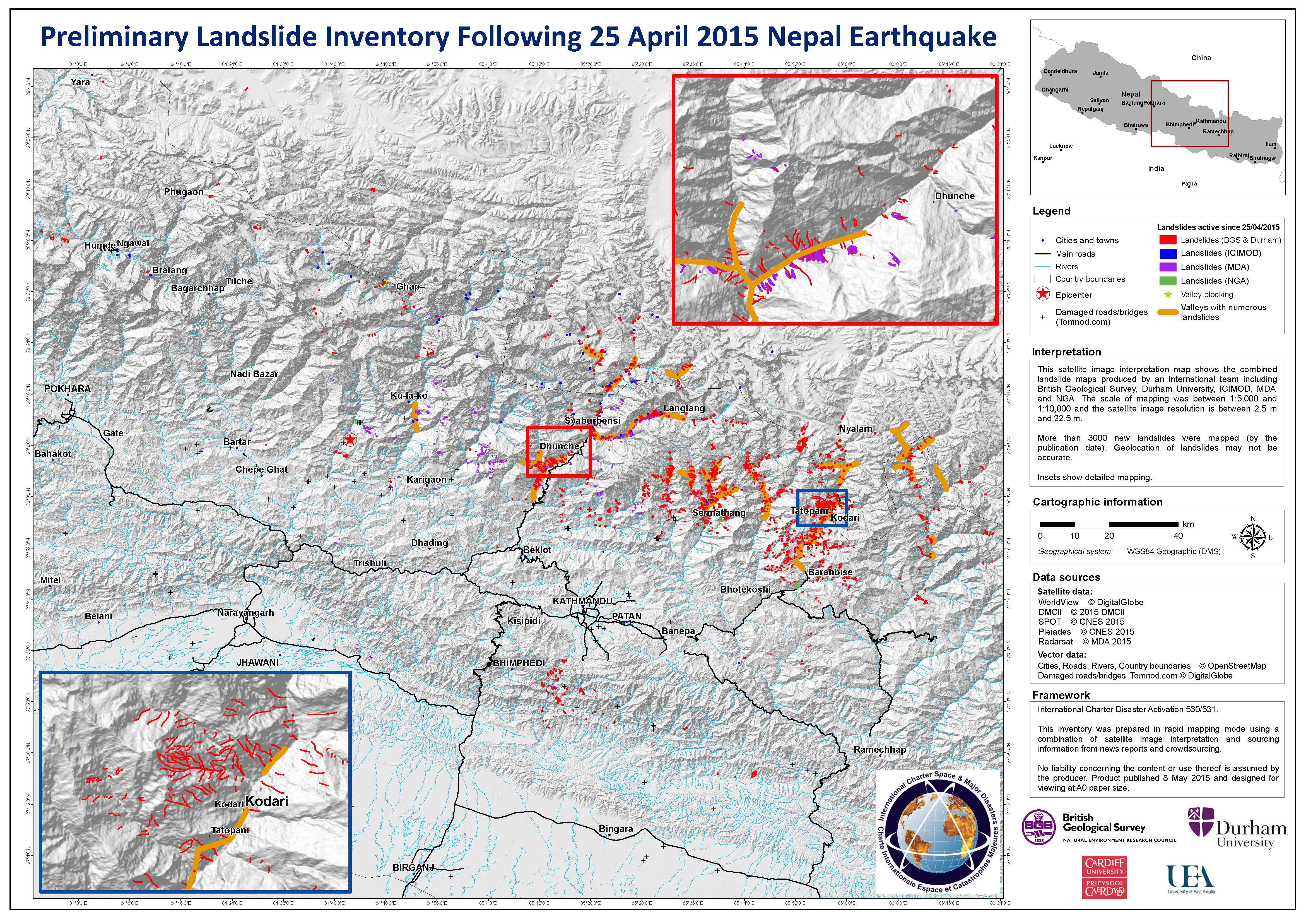
| International Charter | 2015 | Country Overview | Landslide inventory mapping from the British Geologial Survey, Durham University and other agencies, using WorldView/UK-DMC2/SPOT/Pleiades/RADARSAT 2 imagery |
Pacific Disaster Center | 06.05.2015 | Country Overview | Frequency of landslides triggered by precipitation, NGI data |
ESRI | Multiple | Country Overview | |
Pacific Disaster Center | 04.05.2015 | Country Overview | Rainfall accumulation 3-day (TRMM) and Priority Districts (Health Assistance), NASA & WHO data |
Pacific Disaster Center | 04.05.2015 | Country Overview | |
International Charter | 04.05.2015 | Country Overview | |
International Charter | 02.05.2015 | Country Overview | |
International Charter | 30.04.2015 | Country Overview | |
| MDA Geospatial Services | 29.04.2015 | Country Overview | RADARSAT-2 Imaging of the Nepal Earthquake |
Pacific Disaster Center | 03.05.2015 | Country Overview | |
Pacific Disaster Center | 03.05.2015 | Country Overview | |
Pacific Disaster Center | 01.05.2015 | Country Overview | |
European Space Agency | 23.04.2015 | Country Overview | |
| Pacific Disaster Center | 07.05.2015 | IDP camps | IDP Camp Assessment: Drinking Water Sources, IOM data |
| Pacific Disaster Center | 07.05.2015 | IDP camps | IDP Camp Assessment: Type, Population and Management, IOM data |
| Pacific Disaster Center | 07.05.2015 | IDP camps | IDP Camp Assessment: Health, IOM data |
Pacific Disaster Center | 29.04.2015 | Arughat Bazaar | |
International Charter | 27.04.2015 | Bahunepati, Sindhupalchok | |
International Charter | 27.04.2015 | Banepa | Damage assessment map of Banepa, Kathmandu Valley, WorldView-3 imagery |
| Copernicus | 05.05.215 | Barpak | Delineation map, WorldView-2 imagery |
| Copernicus | 09.12.2009 | Barpak | Reference map, ESRI World Imagery |
International Charter | 27.04.2015 | Bhaktapur | Damage assessment map of Bhaktapur, Kathmandu Valley, WorldView-3 imagery |
Copernicus | 27.04.2015 | Bharatpur | |
Copernicus | 08.04.2015 | Bharatpur | |
Copernicus | 03.05.2015 | Betrawati | |
Copernicus | 06.03.2015 | Betrawati | |
Copernicus | 27.04.2015 | Bidur | Damage grading map V3, post-event Pleiades and Worldiew-1 images |
Copernicus | 05.02.2014 | Bidur | Reference map, pre-event WorldView 2 imagery & ESRI World Imagery |
| International Charter | 03.05.2015 | Chaku, Sindhupalchowk | Before and after earthquake images, Landsat 8 OLI / WorldView |
Copernicus | 03.05.2015 | Chilime | |
Copernicus | 09.11.2014 | Chilime | |
Copernicus | 02.05.2015 | Damauli | |
Copernicus | 06.03.2015 | Damauli | |
Copernicus | 02.05.2015 | Deurali | |
Copernicus | 27.02.2015 | Deurali | |
Pacific Disaster Center | 03.05.2015 | Dhading District | |
Copernicus | 03.05.2015 | Dhunche | |
Copernicus | 06.03.2013 | Dhunche | |
| Pacific Disaster Center | 14.05.2015 | Dolakha and Sindhupalchok | Preliminary damge assessment, NGA data |
| Pacific Disaster Center | 12.05.2015 | Dolakha | Preliminary damage assessment, NGA data |
Pacific Disaster Center | 06.05.2015 | Dolakha & Ramechhap Districts | |
International Charter | 27.04.2015 | Gongabu, Dhapasi & Manmaijin VDC | |
Pacific Disaster Center | 03.05.2015 | Gorkha District | Villages and roads affected by identified landslides, ISRO-NRSC data |
Pacific Disaster Center | 03.05.2015 | Gorkha District | |
Copernicus | 29.04.2015 | Gorkha | |
Copernicus | 12.03.2015 | Gorkha | |
| Copernicus | 08.05.2015 | East Gumda | Delineation map V3, WorldView-2 imagery |
Copernicus | 02.05.2015 | Gumda | |
Copernicus | 12.03.2015 | Gumda | |
International Charter | 29.04.2015 | Hansapur area | Damage assessment of Hansapur area, in the Western Region of Nepal, WorldView-1 imagery |
Pacific Disaster Center | 02.05.2015 | Hetauda | |
Copernicus | 01.05.2015 | Hetauda | |
Copernicus | 28.02.2015 | Hetauda | |
International Charter | 27.04.2015 | Imadol | Damage assessment of Imadol VDC, in the Lalitpur District, WorldView-3 imagery |
Copernicus | 02.05.2015 | Jagat | |
Copernicus | 11.03.2015 | Jagat | |
| International Charter | 02.05.2015 | Kathmandu & Bhaktapur | JAXA difference of coherence analysis in Kathmandu and Bhaktapur, with damage assessment, ALOS-2 & PALSAR 2 |
| International Charter | 02.05.2015 | Kathmandu | Damage assessment, KOMPSAT - 3 AEISS |
PDC, HHI | 30.04.2015 | Kathmandu | |
Copernicus | 27.04.2015 | Kathmandu | Damage grading map Version 3, WorldView 3 and Pleiades imagery |
International Charter | 27.04.2015 | Kathmandu, Hanuman Dhoka Square | Suspected damage to buildings in Hanuman Dhoka Square, TerraSAR-X |
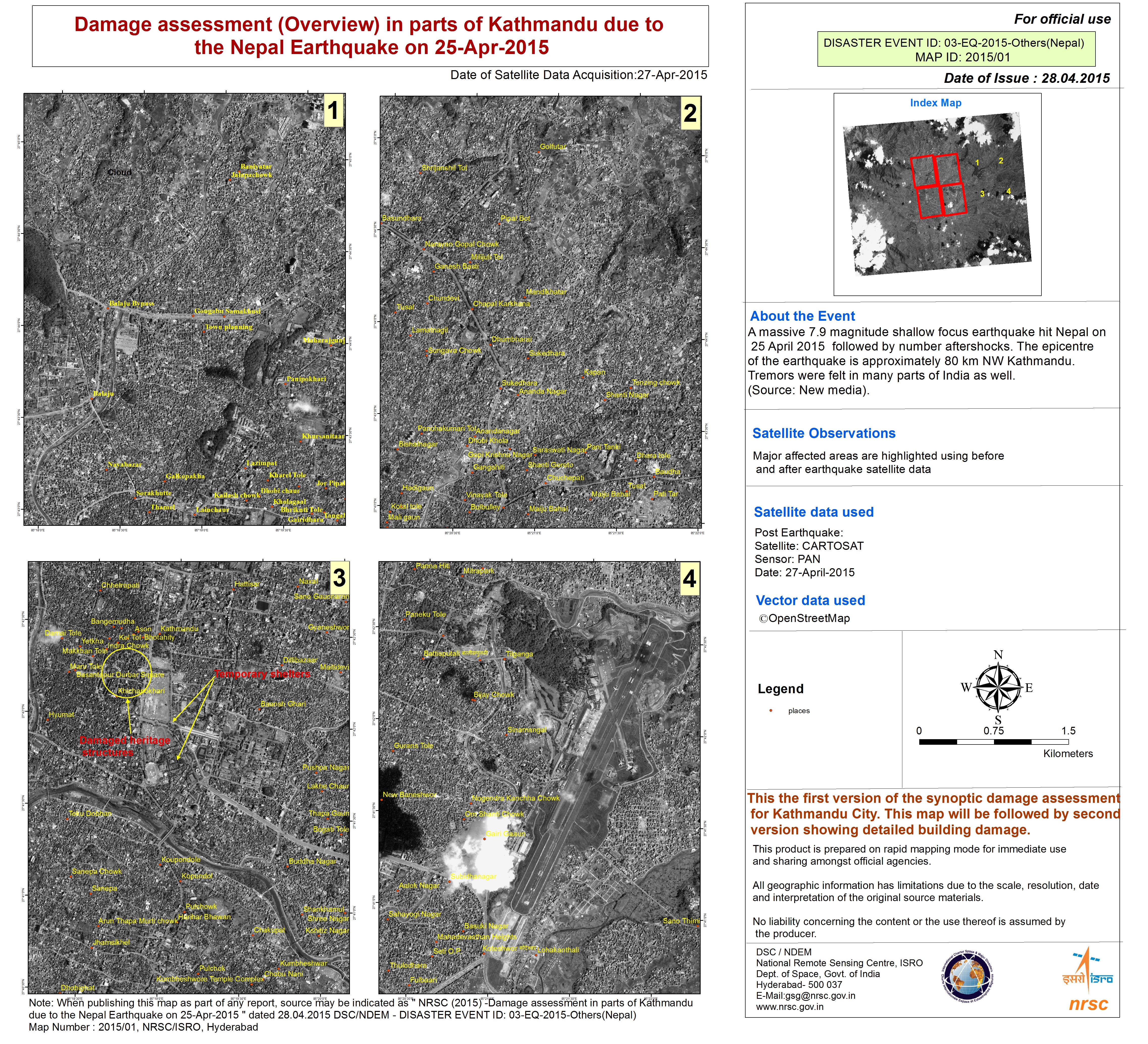
International Charter | 27.04.2015 | Kathmandu | |
International Charter | 27.04.2015 | Kathmandu | Report on damage and displaced persons visible in satellite imagery, Pleiades |
International Charter | 27.04.2015 | Kathmandu | |
Copernicus | 27.04.2015 | Kathmandu | |
Copernicus | 27.04.2015 | Kathmandu | |
International Charter | 27.04.2015 | Kathmandu | |
International Charter | 27.04.2015 | Kathmandu | |
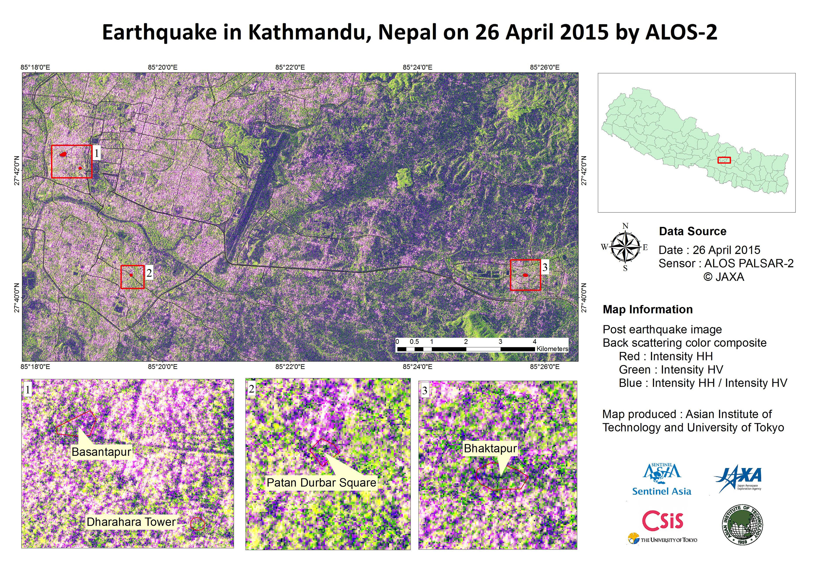
International Charter | 26.04.2015 | Kathmandu | Post earthquake image, back scattered colour composite, ALOS-2 & PALSAR-2 |
Copernicus | 03.11.2013 | Kathmandu | |
DLR-ZKI | 26.01.2014 | Kathmandu (South) | |
DLR-ZKI | 26.01.2014 | Kathmandu (North) | |
DLR-ZKI | 26.01.2014 | Kathmandu (South) | Building height map of Kathmandu as of January 2014, DLR aerial image |
DLR-ZKI | 26.01.2014 | Kathmandu (North) | Building height map of Kathmandu as of January 2014, DLR aerial image |
Ohio State University & Polar Geospatial Center | 07.06.2010 | Kathmandu area | Pre-event 8m posting Digital Elevation Model, Digital Globe stereo imagery & WorldView 1 imagery |
Pacific Disaster Center | 08.05.2015 | Kavrepalanchok & Sindhupalchok | |
Copernicus | 02.05.2015 | Kundule | |
Copernicus | 06.03.2015 | Kundule | |
Pacific Disaster Center | 02.03.2015 | Lamjung & Tanahu | |
HDDS, JAXA | 26.04.2015 | Langtang & Pokhara | |
Pacific Disaster Center | 03.05.2014 | Langtang, Rasuwa District | |
Pacific Disaster Center | 02.05.2015 | Langtang | |
DLR-ZKI | 01.05.2015 | Langtang | |
International Charter | 01.05.2015 | Langtang Village, Rasuwa | Landslides caused by the earthquake - overview map, RapidEye imagery |
International Charter | 30.04.2015 | Langtang Village, Rasuwa | Landslide in Langtang Village, pre-disaster and post-disaster LANDSAT 8 OLI imagery |
Copernicus | 01.05.2015 | Lenkhnath | |
Copernicus | 01.05.2015 | Lenkhnath | |
Copernicus | 06.03.2015 | Lenkhnath | |
Pacific Disaster Center | 04.05.2015 | Makwanpur District | |
International Charter | 29.04.2015 | Muchok area | Damage assessment of Muchok area, in the Western Region of Nepal, WorldView-1 imagery |
Pacific Disaster Center | 03.06.2015 | Nukawot District | |
PDI, HHI | 30.04.2015 | Nuwakot District | |
Copernicus | 29.04.2015 | Pokhara | |
Copernicus | 19.10.2014 | Pokhara | |
International Charter | 27.04.2015 | Tikathali | Damage assessment of Tikathali VDC, in the Lalitpur District, WorldView-3 imagery |
26.04.2015 | Tingla Tingnasa | ||
26.04.2015 | Multiple Regions | ||
International Charter | 27.04.2015 | Sankhu | Damage assessment map of Sankhu, Kathmandu Valley, WorldView-3 imagery |
International Charter | 04.05.2015 | Sindhulpalchok district | |
Pacific Disaster Center | 11.05.2015 | Sindhupalchock District | |
| Copernicus | 08.05.2015 | East Sirdibas | Delineation map V3, WorldView-2 imagery |
| Copernicus | 05.05.2015 | West Sirdibas | Delineation map, WorldView-2 imagery |
| Copernicus | 09.12.2009 | West Sirdibas | Reference map V2 |
| Copernicus | 05.05.2015 | Sirdibas | Delineation map, WorldView-2 imagery |
| Copernicus | 03.04.2008 | Sirdibas | Reference map, ESRI World Imagery |
Copernicus | 01.05.2015 | Sundarbazar | |
Copernicus | 08.04.2015 | Sundarbazar |
The following data is available via HDDS. It is constantly being updated on the HDDS site of USGS. (cf. above how to register and access the data)
Satellite/data name & number of images: | Date: | Link: |
|---|---|---|
| 4 Terra Aster | 03.05.201 | https://hddsexplorer.usgs.gov/criteria?event=201504_Earthquake_NPL&ordered=201504_Earthquake_NPL_NASA_TERRA_ASTER_Day_20150503&field=BATCH_NAME |
| 15 WorldView 1 | 04.05.2015 | https://hddsexplorer.usgs.gov/criteria?event=201504_Earthquake_NPL&ordered=201504_Earthquake_NPL_NGA_WORLDVIEW1_Day_20150504-2&field=BATCH_NAME |
| 43 WorldView 3 | 03.05.2015 | https://hddsexplorer.usgs.gov/criteria?event=201504_Earthquake_NPL&ordered=201504_Earthquake_NPL_NGA_WORLDVIEW3_Day_20150503_Public&field=BATCH_NAME |
| 40 WorldView 3 | 03.05.2015 | https://hddsexplorer.usgs.gov/criteria?event=201504_Earthquake_NPL&ordered=201504_Earthquake_NPL_NGA_WORLDVIEW3_Day_20150503_Public&field=BATCH_NAME |
| 18 WorldView 2 | 02.05.2015 | https://hddsexplorer.usgs.gov/criteria?event=201504_Earthquake_NPL&ordered=201504_Earthquake_NPL_NGA_WORLDVIEW2_Day_20150502_Public&field=BATCH_NAME |
| 74 WorldView 1 | 03.05.2015 | https://hddsexplorer.usgs.gov/criteria?event=201504_Earthquake_NPL&ordered=201504_Earthquake_NPL_NGA_WORLDVIEW1_Day_201150503_Public&field=BATCH_NAME |
| 62 WorldView 3 | 02.05.2015 | https://hddsexplorer.usgs.gov/criteria?event=201504_Earthquake_NPL&ordered=201504_Earthquake_NPL_NGA_WORLDVIEW3_Day_20150502_Public&field=BATCH_NAME |
NGA SAR map products | Various | http://hddsexplorer.usgs.gov/data/list/disaster/201504_Earthquake_NPL/data/MAP_PRODUCTS/NGA |
GeoEye 1 - Lake Imja | 30.04.2015 | |
2 EO-1 | 28.04.2015 | |
4 ASTER | 01.05.2015 | |
18 WorldView 3 | 01.05.2015 | |
Suomi-NPP VIIRS Day/Night Band nighttime omposites | 30.04.2015 | http://hddsexplorer.usgs.gov/data/list/disaster/201504_Earthquake_NPL/data/MAP_PRODUCTS/VIIRS |
Updated damage and loss map | 01/05/2015 | http://hddsexplorer.usgs.gov/data/list/disaster/201504_Earthquake_NPL/data/MAP_PRODUCTS/ICIMOD |
KARI (Kompsat) data | Various | http://hddsexplorer.usgs.gov/data/list/disaster_restricted/201504_Earthquake_NPL_Charter/data/SATELLITE/NON_INGESTED/KARI |
JAXA (ALOS) data | Various | http://hddsexplorer.usgs.gov/data/list/disaster_restricted/201504_Earthquake_NPL_Charter/data/SATELLITE/NON_INGESTED/JAXA |
ESA (Sentinel) data | Various | http://hddsexplorer.usgs.gov/data/list/disaster_restricted/201504_Earthquake_NPL_Charter/data/SATELLITE/NON_INGESTED/ESA |
3 SPOT 6 | Various | |
L8 Mosaics | Pre-event | |
ICIMOD damage map | 03.05.2015 | |
NGA graphics of lakes affected by landslides | 01.05.2015 | http://hddsexplorer.usgs.gov/data/list/disaster/201504_Earthquake_NPL/data/MAP_PRODUCTS/NGA |
Aria Gorkha quake coseismic Sentinel 1 interferogram, Kathmandu | 01.05.2015 | http://hddsexplorer.usgs.gov/data/list/disaster/201504_Earthquake_NPL/data/MAP_PRODUCTS/ARIA |
23 EO-1 | 29.04.2015 | |
4 Terra Aster | 03.05.2015 | |
15 WorldView 1 | 04.05.2015 | |
43 WorldView 3 | 03.05.2015 | |
40 WorldView 3 | 03.05.2015 | |
18 WorldView 2 | 02.05.2015 | |
74 WorldView 1 | 03.05.2015 | |
62 WorldView 3 | 02.05.2015 | |
15 WorldView 1 | 04.05.2015 | |
4 Terra Aster | 03.05.2015 | |
40 WorldView3 | 03.05.2015 | |
43 WorldView 3 | 03.05.2015 | |
74 WorldView 1 | 03.05.2015 | |
62 WorldView 3 | 02.05.2015 | |
18 WorldView 2 | 02.05.2015 | |
23 EO-1 | 29.04.2015 | |
PDC Nepal, USAR locations outside Kathmandu | Various | http://hddsexplorer.usgs.gov/data/list/disaster/201504_Earthquake_NPL/data/MAP_PRODUCTS/PDC |
Planet Labs pre-event imagery | Various |
|
ARIA Gorkha quake coseismic Sentinel-1 interferogram over Kathmandu | 29.04.2015 | http://hddsexplorer.usgs.gov/data/list/disaster/201504_Earthquake_NPL/data/MAP_PRODUCTS/ARIA |
NGA Nepal Earthquake: Damage Assessments | 30.04.2015 | http://hddsexplorer.usgs.gov/data/list/disaster/201504_Earthquake_NPL/data/MAP_PRODUCTS/NGA |
PDC - Nepal Road Infrastructure & Landslide Frequency | Various | http://hddsexplorer.usgs.gov/data/list/disaster/201504_Earthquake_NPL/data/MAP_PRODUCTS/PDC
|
6 L8 pre-event mosaics | 07.09.2014 | |
L8 pre-event mosaic WorldView 1 | Pre-event | |
2 Radarsat 2 | 29.04.2015 | |
1 ASTER | 29.04.2015 | |
1 Landsat 8 image | 28/04.2015 | |
2 EO1 | 26.04.2015 | |
17 GeoEye scenes | Various | |
114 WV3 | 26.04.2015 | |
8 WV3 | 19.11.2014 | |
64 WV2 | Pre event | |
44 WV1 | 26.04.2015 | |
4 Landsat 8 | 28.04.2015 | |
8 WorldView 3 | Pre event | |
149 WorldView 2 | 27.04.2015 | |
11 WorldView 2 | 27.04.2015 | |
50 WorldView 2 | 27.04.2015 | |
11 WorldView 1 | Pre event | |
60 WorldView 3 | 27.04.2015 | |
22 WorldView 2 | 28.04.2015 | |
44 WorldView 1 | 26.04.2015 | |
2 EO-1 | 26.04.2015 | |
2 Landsat 7 | 26.04.2015 | |
1 Pleiades | 26.04.2015 | |
50 WorldView 2 | 27.04.2015 | |
2 Landsat 8 | 26.04.2015 | |
100 World View 2 | 27.04.2015 | |
7 Planet Lab | 27.04.2015 | http://hddsexplorer.usgs.gov/criteria?event=201504_Earthquake_NPL&ordered=201504_Earthquake_NPL_Planet_Labs_20150427&field=BATCH_NAME |
4 Landsat 8 | 25.04.2015 | |
12 WorldView 2 | Pre-event | |
12 Planet Lab | Pre-event | |
3 WorldView 3 | Pre-event | |
6 GeoEye | Pre-event | |
4 Planet Lab | Pre-event | |
1 Planet Lab | Pre-event | |
4 Planet Lab | Pre-event | |
4 Planet lab | Pre-event | |
1 Planet Lab | Pre event | |
1 Planet Lab | Pre-event | |
30 Landsat 8 | Pre-event | |
4 Planet Lab | Pre-event | |
8 GeoEye | Pre-event | |
6 GeoEye | Pre-event | |
4 GeoEye | pre-event | |
2 Worldview 1 | Pre-event | |
8 WorldView 3 | Pre-event | |
9 WorldView 1 | Pre-event | |
5 Planet Lab | Pre-event | |
5 Planet Lab | Pre-event |