The mission was carried out by a UN-SPIDER expert and two experts from the German Aerospace center (DLR).
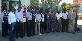
The mission included meetings with representatives from Department of Water Affairs and Forestry of the Ministry of Agriculture Water and Forestry, the German Technical Cooperation Agency (GTZ) UNDP and the Directorate Emergency Management of the Office of the Prime Minister. The mission included a stakeholder workshop bringing together more than 50 participants from public and private sector of Namibia.
The mission took note of the fact that decision makers in Namibia are not really aware of the potential uses of space-based technology for disaster management;
A limited number of institutions have basic capacity to work with space-based information and technology such as GPS. However, the Department of Water Affairs and Forestry possess the necessary technical skills and in part also the equipment and the basic information layers to act as an information hub in an emergency situation;
As far as remote sensing software is concerned, geospatial imagery processing application belonging to the ERDAS portfolio are in use as well as other open source software, i.e. ILWIS;
Space-based technology and information have not yet been exploited in Namibia in a systematic way in the context of risk analysis and mapping; but very recently high resolution aerial ortho-photos have been incorporated into risk zoning of some urban areas of the country.
The flow of disaster-relevant information among different government institutions is weak due to the lack of a spatial database infrastructure;
The Government institutions are not in the position to activate the International Charter “Space and Major Disasters).
Namibia could benefit from training efforts which would enhance basic capacities and development activities in the field of remote sensing, GPS and GIS for different institutions depending on their role and level;
The ad hoc task force group that was suggested as one major outcome of the working groups to foster the integration of space-based information and technology elements into the National Multi-risk Contingency Plan should be further supported;
The Government should nominate a focal point to request the activation of the International Charter “Space and Major Disasters” in the case of an emergency through the appropriate channels; and to request support to UN-SPIDER;
The compilation and integration of paper-based disaster information and other information sources such as geophysical data, hydro-meteorological modelling approaches/results grated to make it useful for risk assessment (e.g. flood risk zone analysis based on records of historical events);
The government to promote the establishment of the Namibian Geospatial Data Infrastructure with the support of UN-SPIDER and UNGIWG;
Space-based information and technology elements to be introduced into the national multi-risk contingency plan at the appropriate location, e.g. for flood damage assessment and flood risk zoning.