• English
  • Español
  • Français

United
Nations


Office for Outer Space Affairs
UN-SPIDER Knowledge Portal

  • Accueil
  • À propos
    • Qu'est-ce que l'ONU-SPIDER?
    • À propos d’UNOOSA
    • Publications
    • Offres d'emploi
    • Rencontrez l'équipe
    • Contact
  • Applications spatiales
    • Technologie satellitaire
    • Mécanismes d’urgence
    • Recovery Mechanisms
    • Réseau international d'alerte aux astéroïdes
    • Space Mission Planning Advisory Group
    • Initiative internationale sur la météorologie spatiale
    • Les technologies spatiales à l'ONU
    • Comptes-rendus d'utilisateurs
  • Liens & ressources
    • Application de données du mois
      • Disaster Recovery
    • Sources de données
    • SIG et logiciels de télédétection
    • Online Learning Resources
    • Institutions
  • Risques & catastrophes
    • Prévention des risques de catastrophe
    • Systèmes d'alerte précoce
    • Gestion des catastrophes et des interventions d'urgence
    • Aléas naturels
    • Cadre d'action de Sendai
    • L'ONU et la prévention des risques de catastrophe
    • L'ONU et les alertes précoces
    • L'ONU et la gestion des catastrophes
  • Appui technique
    • Missions Conseil
    • Appui d’urgence
    • Appui à distance
    • Pratiques recommandées
    • Activités de formation
    • Utilisations pratiques
  • Réseaux
    • Bureaux régionaux d’appui
    • GP-STAR
    • MHEWS
    • IWG-SEM
  • Projets
    • SPEAR
    • SEWS-D
    • EvIDENz
    • Flood GUIDE
  • Actualités
    • Actualités
    • Événements
    • Événements passés

Breadcrumb

  • Home
  • USGS Releases New National Seismic Maps
  • USGS releases new national seismic maps

USGS releases new national seismic maps

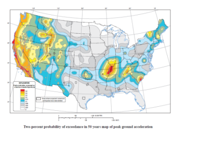
Seismic Hazard Map of the US released in 2014 by USGSSeismic Hazard Map of the US released in 2014 by USGS

On 17 July 2014, USGS released several Updated National Seismic Hazard Maps, accompanied with a report for the 2014 Update of the United States National Seismic Hazard Maps.

The report, “Documentation for the 2014 Update of the United States National Seismic Hazard Maps,” highlights the increasing role of geodetic data, derived primarily from high-accuracy, continuously operating GPS reference stations, in assessing earthquake risk.

“Modern GPS data provide more spatially complete observations on ground deformation, cover a period of 25 years (from 1987–2012), and record the most recent plate-loading rates with submillimeter per year precision, which is more precise than data provided by geologic studies,” the USGS researchers wrote in their report.

According to the maps, all US States have some potential for earthquakes, with peaks along the West Coast, intermountain West, and in several active regions of the central and eastern United States. USGS made forecasts concerning the percentage of risk for every state and made estimations on 16 states at highest risk.

These outcomes could encourage the establishment of a West Coast Earthquake Early Warning (WC-EEW) system, called ShakeAlert, proposed by USGS along with partners among universities and state and local agencies. Shake Alert would work for the highest-risk areas of the United States, providing GPS reference networks to the current earthquake monitoring capabilities of the Advanced National Seismic System. The system would provide safety benefits in homes and schools, computer systems and machinery, preventing loss of life or damage to property by helping in determining emergency preparedness plans.
USGS
Mon, 28 Jul 2014 - 12:01

Footer menu

  • Contact
  • Terms of Use

User account menu

  • Log in