• English
  • Español
  • Français

United
Nations


Office for Outer Space Affairs
UN-SPIDER Knowledge Portal

  • Accueil
  • À propos
    • Qu'est-ce que l'ONU-SPIDER?
    • À propos d’UNOOSA
    • Publications
    • Offres d'emploi
    • Rencontrez l'équipe
    • Contact
  • Applications spatiales
    • Technologie satellitaire
    • Mécanismes d’urgence
    • Recovery Mechanisms
    • Réseau international d'alerte aux astéroïdes
    • Space Mission Planning Advisory Group
    • Initiative internationale sur la météorologie spatiale
    • Les technologies spatiales à l'ONU
    • Comptes-rendus d'utilisateurs
  • Liens & ressources
    • Application de données du mois
      • Disaster Recovery
    • Sources de données
    • SIG et logiciels de télédétection
    • Online Learning Resources
    • Institutions
  • Risques & catastrophes
    • Prévention des risques de catastrophe
    • Systèmes d'alerte précoce
    • Gestion des catastrophes et des interventions d'urgence
    • Aléas naturels
    • Cadre d'action de Sendai
    • L'ONU et la prévention des risques de catastrophe
    • L'ONU et les alertes précoces
    • L'ONU et la gestion des catastrophes
  • Appui technique
    • Missions Conseil
    • Appui d’urgence
    • Appui à distance
    • Pratiques recommandées
    • Activités de formation
    • Utilisations pratiques
  • Réseaux
    • Bureaux régionaux d’appui
    • GP-STAR
    • MHEWS
    • IWG-SEM
  • Projets
    • SPEAR
    • SEWS-D
    • EvIDENz
    • Flood GUIDE
  • Actualités
    • Actualités
    • Événements
    • Événements passés

Breadcrumb

  • Home
  • International Charter Activated For Flooding In Southern Brazil
  • International Charter activated for flooding in Southern Brazil

International Charter activated for flooding in Southern Brazil

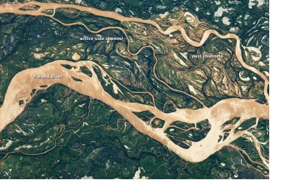
Image of Parana River Flood PlaneSatellite image of Parana River Flood Plane

On 14 June 2014 the International Charter: Space and Major Disasters was activated at the request of the Brazilian Disaster Risk Management National Centre (CENAD) in response to flooding and landslides caused by heavy rainfall from 07 and 10 of June 2014 affecting the states of Santa Catarina and Parana.

Due to the flooding and landslides ten people have died and six are still reported as missing, an estimated 40,000 people have been evacuated and 130 cities have been affected. Flooding of the Parana River has impacted not only Brazil but Argentina and Paraguay as well.

Satellite-based products and maps created through the mechanism will be published on the International Charter's website as soon as they become available.

Additionally to the efforts of the International Charter, the crowdsource mapping organization MapAction has deployed volunteers to support relief efforts in Paraguay where around 160 000 people have been affected by the inundations. The situation might worsen as the forecasts predict continuous rain for several weeks.
International Charter
Tue, 17 Jun 2014 - 13:41
Argentina
Brazil

Footer menu

  • Contact
  • Terms of Use

User account menu

  • Log in