• English
  • Español
  • Français

United
Nations


Office for Outer Space Affairs
UN-SPIDER Knowledge Portal

  • Accueil
  • À propos
    • Qu'est-ce que l'ONU-SPIDER?
    • À propos d’UNOOSA
    • Publications
    • Offres d'emploi
    • Rencontrez l'équipe
    • Contact
  • Applications spatiales
    • Technologie satellitaire
    • Mécanismes d’urgence
    • Recovery Mechanisms
    • Réseau international d'alerte aux astéroïdes
    • Space Mission Planning Advisory Group
    • Initiative internationale sur la météorologie spatiale
    • Les technologies spatiales à l'ONU
    • Comptes-rendus d'utilisateurs
  • Liens & ressources
    • Application de données du mois
      • Disaster Recovery
    • Sources de données
    • SIG et logiciels de télédétection
    • Online Learning Resources
    • Institutions
  • Risques & catastrophes
    • Prévention des risques de catastrophe
    • Systèmes d'alerte précoce
    • Gestion des catastrophes et des interventions d'urgence
    • Aléas naturels
    • Cadre d'action de Sendai
    • L'ONU et la prévention des risques de catastrophe
    • L'ONU et les alertes précoces
    • L'ONU et la gestion des catastrophes
  • Appui technique
    • Missions Conseil
    • Appui d’urgence
    • Appui à distance
    • Pratiques recommandées
    • Activités de formation
    • Utilisations pratiques
  • Réseaux
    • Bureaux régionaux d’appui
    • GP-STAR
    • MHEWS
    • IWG-SEM
  • Projets
    • SPEAR
    • SEWS-D
    • EvIDENz
    • Flood GUIDE
  • Actualités
    • Actualités
    • Événements
    • Événements passés

Breadcrumb

  • Home
  • Gaza Strip: International Charter Activated Due To Flood And Storm
  • Gaza Strip: International Charter activated due to flood and storm

Gaza Strip: International Charter activated due to flood and storm

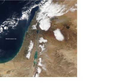
Satellite image shows the snow storm over the Gaza strip that caused floodingsRare Middle Eastern Snow

On 17 December 2013, the International Charter: Space and Major Disasters was activated, as requested by UNITAR/UNOSAT on behalf of UNOCHA, due to flood and a storm in Gaza Strip. Since 12 December, a winter storm, Alexa, has struck the Middle East causing days of snow and heavy rain. The, reportedly, worst storm of the region in over sixty years, has resulted in flooding in the Gaza Strip that has forced the evacuation of over 5000 people.

Many homes in Gaza were ill-equipped to cope with the almost unprecedented weather, which brought floodwaters to two metres high in some areas. The northern part of the Gaza Strip has been declared a disaster area, where thousands of evacuees' have been moved to schools and emergency shelters and thousands of homes have been inundated or left without power.

The Moderate Resolution Imaging Spectroradiometer (MODIS) on NASA’s Terra satellite acquired this image of the snow on December 15. The floods caused by the storm are not visible at this scale, but tan and green plumes of sediment are visible along the Mediterranean Sea coast. Such plumes can be caused by floodings.
International Charter
Wed, 18 Dec 2013 - 09:01

Footer menu

  • Contact
  • Terms of Use

User account menu

  • Log in