• English
  • Español
  • Français

United
Nations


Office for Outer Space Affairs
UN-SPIDER Knowledge Portal

  • Accueil
  • À propos
    • Qu'est-ce que l'ONU-SPIDER?
    • À propos d’UNOOSA
    • Publications
    • Offres d'emploi
    • Rencontrez l'équipe
    • Contact
  • Applications spatiales
    • Technologie satellitaire
    • Mécanismes d’urgence
    • Recovery Mechanisms
    • Réseau international d'alerte aux astéroïdes
    • Space Mission Planning Advisory Group
    • Initiative internationale sur la météorologie spatiale
    • Les technologies spatiales à l'ONU
    • Comptes-rendus d'utilisateurs
  • Liens & ressources
    • Application de données du mois
      • Disaster Recovery
    • Sources de données
    • SIG et logiciels de télédétection
    • Online Learning Resources
    • Institutions
  • Risques & catastrophes
    • Prévention des risques de catastrophe
    • Systèmes d'alerte précoce
    • Gestion des catastrophes et des interventions d'urgence
    • Aléas naturels
    • Cadre d'action de Sendai
    • L'ONU et la prévention des risques de catastrophe
    • L'ONU et les alertes précoces
    • L'ONU et la gestion des catastrophes
  • Appui technique
    • Missions Conseil
    • Appui d’urgence
    • Appui à distance
    • Pratiques recommandées
    • Activités de formation
    • Utilisations pratiques
  • Réseaux
    • Bureaux régionaux d’appui
    • GP-STAR
    • MHEWS
    • IWG-SEM
  • Projets
    • SPEAR
    • SEWS-D
    • EvIDENz
    • Flood GUIDE
    • CommonSpace Initiative
  • Actualités
    • Actualités
    • Événements
    • Événements passés

Breadcrumb

  • Home
  • Using Space Technology To Monitor Flooding In Thailand
  • Using space technology to monitor flooding in Thailand

Using space technology to monitor flooding in Thailand

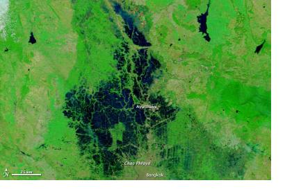
Severe flooding affected large stretches of Thailand’s Chao Phraya RiverSevere flooding affected large stretches of Thailand’s Chao Phraya River by October 2011.

The South Asia region is especially prone to flooding. Annually, flooding takes hundred of lives and causes damages in tens of billions US dollars.

In a collaboration of NASA’s Jet Propulsion Laboratory and the Hydro and Agro Informatics Institute of Thailand, sensorweb technologies are being used to enhance monitoring of flooding especially in Thailand. This technique is used for detection, early warning and analysis of high resolution imagery.

Using MODIS imagery the system is able to automatically detect flooding areas. In partnership with other automatic and semi automatic tools information about the spread and depth of surface water is analyzed and forwarded to appropriate disaster response points of contact. Depending on the timing and the sensor used the whole process of detection and delivery can take from one to several days.

Future plans include integrating in-situ data sources and hydrological models as well as additional sensors such as ASTER.
Earthzine
Fri, 6 Dec 2013 - 14:00
Thailand

Footer menu

  • Contact
  • Terms of Use

User account menu

  • Log in