• English
  • Español
  • Français

United
Nations


Office for Outer Space Affairs
UN-SPIDER Knowledge Portal

  • Accueil
  • À propos
    • Qu'est-ce que l'ONU-SPIDER?
    • À propos d’UNOOSA
    • Publications
    • Offres d'emploi
    • Rencontrez l'équipe
    • Contact
  • Applications spatiales
    • Technologie satellitaire
    • Mécanismes d’urgence
    • Recovery Mechanisms
    • Réseau international d'alerte aux astéroïdes
    • Space Mission Planning Advisory Group
    • Initiative internationale sur la météorologie spatiale
    • Les technologies spatiales à l'ONU
    • Comptes-rendus d'utilisateurs
  • Liens & ressources
    • Application de données du mois
      • Disaster Recovery
    • Sources de données
    • SIG et logiciels de télédétection
    • Online Learning Resources
    • Institutions
  • Risques & catastrophes
    • Prévention des risques de catastrophe
    • Systèmes d'alerte précoce
    • Gestion des catastrophes et des interventions d'urgence
    • Aléas naturels
    • Cadre d'action de Sendai
    • L'ONU et la prévention des risques de catastrophe
    • L'ONU et les alertes précoces
    • L'ONU et la gestion des catastrophes
  • Appui technique
    • Missions Conseil
    • Appui d’urgence
    • Appui à distance
    • Pratiques recommandées
    • Activités de formation
    • Utilisations pratiques
  • Réseaux
    • Bureaux régionaux d’appui
    • GP-STAR
    • MHEWS
    • IWG-SEM
  • Projets
    • SPEAR
    • SEWS-D
    • EvIDENz
    • Flood GUIDE
  • Actualités
    • Actualités
    • Événements
    • Événements passés

Breadcrumb

  • Home
  • Vegetation Monitoring: First Global Map of Vegetation Unveiled
  • Vegetation monitoring: First global map of vegetation unveiled

Vegetation monitoring: First global map of vegetation unveiled

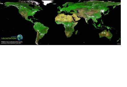
First image of vegetation mapping satellite Proba 5Proba-V satellite: First mosaic

In the beginning of June, the first global map of vegetation from the recently launched Proba-V has been unveiled, demonstrating that the minisatellite is on track to continue a 15-year legacy of global vegetation monitoring from space.

Proba-V is the fourth satellite in the European Space Agency's PROBA series. It is designed to map land cover and vegetation growth across the entire planet every two days. The data can also be used for day-by-day tracking of extreme weather, alerting authorities to crop failures, monitoring inland water resources and tracing the steady spread of deserts and deforestation.

While still being commissioned, the satellite continued to acquire images that have been stitched together to give us the mission’s first, uncalibrated map of global vegetation – unveiled at the Probing Vegetation conference that took place from 4 to 5 July 2013 in Antwerp, Belgium.
ESA
Thu, 18 Jul 2013 - 07:43

Footer menu

  • Contact
  • Terms of Use

User account menu

  • Log in