• English
  • Español
  • Français

United
Nations


Office for Outer Space Affairs
UN-SPIDER Knowledge Portal

  • Accueil
  • À propos
    • Qu'est-ce que l'ONU-SPIDER?
    • À propos d’UNOOSA
    • Publications
    • Offres d'emploi
    • Rencontrez l'équipe
    • Contact
  • Applications spatiales
    • Technologie satellitaire
    • Mécanismes d’urgence
    • Recovery Mechanisms
    • Réseau international d'alerte aux astéroïdes
    • Space Mission Planning Advisory Group
    • Initiative internationale sur la météorologie spatiale
    • Les technologies spatiales à l'ONU
    • Comptes-rendus d'utilisateurs
  • Liens & ressources
    • Application de données du mois
      • Disaster Recovery
    • Sources de données
    • SIG et logiciels de télédétection
    • Online Learning Resources
    • Institutions
  • Risques & catastrophes
    • Prévention des risques de catastrophe
    • Systèmes d'alerte précoce
    • Gestion des catastrophes et des interventions d'urgence
    • Aléas naturels
    • Cadre d'action de Sendai
    • L'ONU et la prévention des risques de catastrophe
    • L'ONU et les alertes précoces
    • L'ONU et la gestion des catastrophes
  • Appui technique
    • Missions Conseil
    • Appui d’urgence
    • Appui à distance
    • Pratiques recommandées
    • Activités de formation
    • Utilisations pratiques
  • Réseaux
    • Bureaux régionaux d’appui
    • GP-STAR
    • MHEWS
    • IWG-SEM
  • Projets
    • SPEAR
    • SEWS-D
    • EvIDENz
    • Flood GUIDE
    • CommonSpace Initiative
  • Actualités
    • Actualités
    • Événements
    • Événements passés

Breadcrumb

  • Home
  • Hurricane Sandy: Polar-orbiting Satellites Were Key In Pinpointing Landfall
  • Hurricane Sandy: Polar-orbiting satellites were key in pinpointing landfall

Hurricane Sandy: Polar-orbiting satellites were key in pinpointing landfall

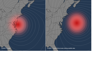
This image shows where Sandy was predicted to be located five-days out with the normal satellite data inputs into the model (left) and without any polar-orbiting satellite data (right).

According to a new study by the European Centre for Medium-Range Weather Forecasts (ECMWF), the NOAA forecasts of Hurricane Sandy’s track could have been hundreds of miles off without information from polar-orbiting satellites. Rather than identifying the New Jersey landfall location within 30 miles five-days before landfall, the models would have shown Sandy remaining at sea.

“This study shows the value of polar-orbiting satellites in developing life-saving forecasts with longer lead times," said Dr. Kathryn Sullivan, assistant secretary of commerce for environmental observation and prediction, and deputy NOAA administrator. “Had we thought the brunt of the storm was going to stay out in the Atlantic, or if residents had only a day to prepare or evacuate, the results would have been even more devastating.”

The ECMWF is an independent, intergovernmental organization supported by 34 European nations, providing global medium-to-extended range forecasts.
NOAA
Fri, 14 Dec 2012 - 08:17

Footer menu

  • Contact
  • Terms of Use

User account menu

  • Log in