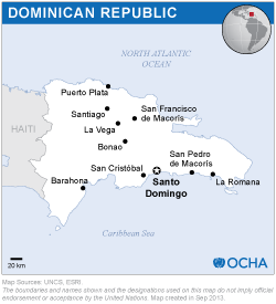
The mission was conducted by two experts from UN-SPIDER, who were accompanied by experts from the Panama-based Water Center for the Humid Tropics of Latin America and the Caribbean (CATHALAC) and from the Bolivarian Space Agency (Venezuela).
The mission included visits to 11 Government agencies and included an inter-institutional workshop organized by the National Emergency Commission (CNE), which was attended by a variety of institutions, including universities, NGOs and the private sector.
Disaster-risk management is a topic that has been receiving more and more attention in recent years in the Dominican Republic, particularly through the enactment of the new Law 147-02 in 2002. The law targets specifically two policies which are of relevance in the context of space-based information: the National Integrated Information System and the recognition regarding institutional strengthening through capacity building efforts.
Several government agencies have the capacity to access space-based data and generate information. As in the case of other countries, it is the institutions that deal with naturals resources such as the National Secretariat for the Environment and Human Resources (SEMARENA) and the National Institute of Water Resources (INDRHI) as well as the Military Cartographic Institute and the University Geographic Institute (IGU) that have the best capacities.
Several National Secretariats have the mandate to establish thematic information systems. Efforts are being conducted to implement the National Geospatial Database Infrastructure as a way to facilitate the sharing of information among government institutions. INDHRI acquired high-resolution aerial photography of the whole country at a 1:20,000 scale between the years 2000 and 2004.
The National Emergency Operations Center is aware of the International Charter: Space and Major Disasters, and finds its Pdf maps useful particularly to make use of them in the field in case of disasters. Several organizations, including NGOS, have generated a variety of hazard, vulnerability and risk maps from different regions in the country.
The mission recommended to CNE the promotion of the use of space-based information, in particular during disasters. Efforts should be made by CNE to incorporate a task along these lines within the Manual of Operations of the National Emergency Operations Centre.
Taking note of the institutional mandates and arrangements and following examples from other countries in Latin America, CNE should establish an inter-institutional group that focuses on the processing of satellite imagery to generate relevant information. The institutionalization could be carried out through a Memorandum of Understanding or a similar approach and strengthen the skills of the group. UN-SPIDER could also contribute to the strengthening of skills of the group.
The Technical Committee on Prevention and Mitigation of Risks should homogenize the different hazard, vulnerability and risk maps that have been elaborated by different agencies and organizations, and should promote the use of guidelines or standards in the elaboration of new maps of these kinds.
The Technical Committee on Prevention and Mitigation of Risks should implement that National Integrated Information System and promote its use in risk management efforts throughout the country.
A national policy should be established by the Government towards the establishment of the National Geospatial Database Infrastructure, and a policy so that government agencies exchange information more easily;
CNE should implemented a training programme to increase the skills of staff on the use of satellite imagery, including radar imagery in the case of floods. ITLA or the National Autonomous University of Santo Domingo could implement such a programme.


