
New Study Introduces a Satellite-Driven Model for Sand and Dust Storm Emission Predictions
For nearly four decades, the models used to forecast sand and dust storm severity have relied on assumptions now shown to limit their accuracy. A new study, coordinated by an international research team at Cardiff University, now offers a way forward by introducing a satellite-based model that significantly improves the reliability of how wind-driven sediment movement is estimated across the globe.
Rethinking a Four-Decade-Old Assumption
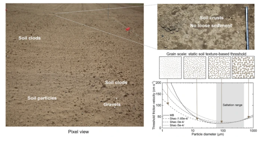
The study, published in Nature Communications Earth and Environment, identifies a core weakness in how sand and dust storm (SDS) prediction models have long been constructed. These models, which draw on surface, satellite, Light Detection and Ranging (LiDAR), and weather data, have long operated on the premise that soil surfaces do not vary over time. By holding key wind-driven sediment thresholds constant and assuming a continuous supply of loose material, models have effectively been overlooking how soil surfaces evolve in reality.
This oversimplification, the researchers argue, has produced a consistent overestimation of both the geographic extent and total volume of sediment movement worldwide, undermining the reliability of the early warning systems (EWS) that depend on them. In response, the team developed dEARTH, a model that moves away from static surface assumptions by continuously tracking how soil conditions evolve. Drawing on space-based satellite observations, dEARTH accounts for factors such as surface roughness, vegetation cover, soil crusting, and fluctuations in sediment availability, all of which are detected and measured from space through satellites.
Testing dEARTH: Striking Differences in Global Sediment Estimates
When tested against conventional models using 2024 data, dEARTH produced markedly different results. The land area affected by sediment transport was 69 percent smaller, while the total volume of material moved globally was 45 percent lower. These figures suggest that existing approaches have been considerably overstating the scale of wind-driven erosion extent and fluxes, reducing the accuracy of EWS and dust emission modelling.
Lead author Dr Zhuoli Zhou of Cardiff University's School of Earth and Environmental Sciences noted that accounting for how surface roughness and soil conditions shift over time is essential for producing estimates that better reflect actual conditions. While more accurate modelling does not in itself reduce vulnerability to the climate and health impacts of SDS, it provides a stronger foundation for EWS.
Source: Zhou, Z., Chappell, A., Zhang, C. et al. Satellite retrieved soil surface dynamics reduce the extent and frequency of sediment flux with implications for early warning systems. Commun Earth Environ 7, 259 (2026). https://doi.org/10.1038/s43247-026-03368-4
The Link Between Satellite Technology, EWS and Disaster Risk Management
The implications of dEARTH extend far beyond academic research. Operational tools such as sand and dust storm EWS, air quality hazard systems, dust and climate interaction models, and land degradation assessments all depend on a sound understanding of sediment transport. In particular, this involves recognising how often and how intensively sediment is moved, along with the magnitude and frequency of dust emissions. Greater accuracy in that underlying data has the potential to strengthen forecast reliability and inform more effective mitigation strategies at both regional and global levels.
The research is particularly timely, coinciding with the United Nations Decade to Combat Sand and Dust Storms, running from 2025 to 2034. The team is now working to bring the dynamic surface thresholds that power dEARTH into operational dust emission and early warning frameworks. Their longer-term ambition is to establish a satellite remote sensing platform dedicated to monitoring wind erosion and dust emissions worldwide, with practical relevance for land management and the tracking of long-term environmental change.
Co-author Professor Adrian Chappell, from Cardiff University, pointed to advances in satellite technology as the enabler of this shift. He noted that optical remote sensing now makes it possible to represent how soil surfaces vary across different locations and seasons, something that broad numerical generalisations simply cannot achieve. The outcome is a model that, for the first time in over three decades, captures the way sediment entrainment evolves across both space and time.
As a result, EWS for sand and dust storms, climate and dust interaction models, air quality hazard systems, and global land degradation assessments are now better equipped to capture how often and how intensely sediment transport and dust emissions occur. This should strengthen the reliability of models, enhance their forecast performance, and improve the effectiveness of mitigation policy and practice both regionally and globally.
Read the original article here: https://www.preventionweb.net/news/satellite-driven-model-provides-more-realistic-and-reliable-predictions-sand-and-dust-storm