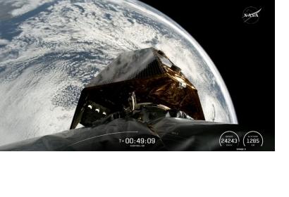
Vandenberg Space Force Base, 17 November 2025 – The Copernicus Sentinel-6B satellite launched at 06:21 CET aboard a SpaceX Falcon 9 from Vandenberg Space Force Base in California, marking the arrival of the latest satellite dedicated to monitoring global sea-level rise. The spacecraft entered orbit just under an hour after liftoff, and ESA’s European Space Operations Centre received its first signal at 07:54 CET via the Inuvik ground station in Canada, confirming the satellite was functioning as expected. Sentinel-6B now begins its role in extending the sea-surface height record, continuing a climate-critical data series that began more than three decades ago.
Extending a Three-Decade Sea-Level Record
Sentinel-6B carries advanced radar altimetry technology identical to its predecessor, Sentinel-6 Michael Freilich, launched in November 2020. Together, the Sentinel-6 satellites form the primary global reference mission for sea-surface height measurements, supporting scientific understanding of long-term sea-level rise. This data record began in the early 1990s with the French–US Topex-Poseidon mission and was continued through the Jason satellite series. By extending this unbroken dataset, Sentinel-6B ensures precise monitoring of sea-level trends and supports the development of evidence-based climate policy for millions living in low-lying coastal regions.

The mission is part of the European Union’s Copernicus program and represents broad international cooperation. Sentinel-6 was jointly developed by the European Commission, ESA, NASA, Eumetsat, and NOAA, with additional support from CNES. This partnership underpins the mission’s role as the global standard for high-precision ocean-altimetry measurements.
Simonetta Cheli, ESA’s Director of Earth Observation Programmes, declared, “This achievement demonstrates what can be accomplished when international agencies and industries work together toward a shared goal. Sentinel-6B will ensure that we continue to collect the high-precision data needed to understand our changing climate, safeguard our oceans, and support decisions that protect coastal communities around the world.”
Mapping the Oceans with High-Precision Altimetry
Beyond its role in long-term sea-level monitoring, Sentinel-6B delivers operational ocean measurements used for near-real-time applications. The mission provides data on significant wave height and wind speed, ocean currents, and extreme weather systems. This supports ocean forecasting and contributes to the most comprehensive ocean sea-state measurements available today. The mission also maps 95% of Earth’s ice-free oceans every ten days.

The satellite’s altimeter measures the time it takes radar pulses to travel to the ocean surface and return to the satellite. Combined with precise orbit information, these measurements produce accurate estimates of sea-surface height. The spacecraft’s instrument package also includes an advanced microwave radiometer supplied by NASA. Because atmospheric water vapor affects the speed of radar pulses, the radiometer accounts for these variations and ensures the accuracy of the mission’s sea-surface height observations.
Next Steps for Sentinel-6B
Following the launch, Sentinel-6B entered ESA’s Launch and Early Orbit Phase under the care of mission control in Germany. Once this phase is complete, the satellite will be handed over to Eumetsat. By strengthening the multi-decade sea-level record, Sentinel-6B provides the high-precision measurements needed to monitor climate change, safeguard the oceans, and support policymaking that protects coastal communities worldwide.

