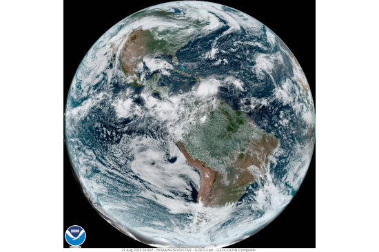
For nearly 50 years, the National Oceanic and Atmospheric Administration (NOAA) of the United States has been operating its constellation of Geostationary Operational Environmental Satellites (GOES) to contribute to improving weather forecasts, storm tracking, and for other applications in agriculture, oceanography, atmospheric physics and space weather observations. Figure 2.3 shows a satellite image from the American hemisphere acquired in August 2023.
The first three GOES satellites were launched between 1975 and 1993 and contributed to monitoring weather on land and at sea. The GOES 4, 5, 6 and 7 satellites were launched between 1980 and 1996 and included sensors to obtain vertical profiles of temperature and moisture at various elevations and allowed for improved forecasting of the intensity and extent of storms.
The GOES 8, 9, 10, 11 and 12 satellites were launched between 1994 and 2014 and were fitted with higher resolution sensors and larger capacity for data collection. The GOES 13, 14 and 15 satellites were launched between 2006 and 2020 and included even better resolutions that enabled the location of intense storms to be pinpointed. These were also the first satellites fitted with instruments to monitor space weather.
The newest GOES 16, 17 and 18 satellites were launched between 2016 and 2022 and are used to monitor different regions of the planet (GOES East and GOES West). The GOES 16 satellite included an Advanced Baseline Imager (ABI) that can scan the full disc of the planet and more localized areas as often as every 30 seconds to enhance the accuracy of short-term weather forecasts. The ABI includes 16 different spectral bands in the visible and infrared segments of the electromagnetic spectrum.
Meteorological offices and institutes around the world continue to benefit from the data generated by the GOES constellation. In addition, the National Hurricane Centre combines satellite observations from GOES and other satellites, aerial observations from reconnaissance aircraft, and data acquired from sensors in ships, buoys, radar and other land-based platforms to monitor the spatial and temporal characteristics of tropical storms and hurricanes.
