• English
  • Español
  • Français

United
Nations


Office for Outer Space Affairs
UN-SPIDER Knowledge Portal

  • Accueil
  • À propos
    • Qu'est-ce que l'ONU-SPIDER?
    • À propos d’UNOOSA
    • Publications
    • Offres d'emploi
    • Rencontrez l'équipe
    • Contact
  • Applications spatiales
    • Technologie satellitaire
    • Mécanismes d’urgence
    • Recovery Mechanisms
    • Réseau international d'alerte aux astéroïdes
    • Space Mission Planning Advisory Group
    • Initiative internationale sur la météorologie spatiale
    • Les technologies spatiales à l'ONU
    • Comptes-rendus d'utilisateurs
  • Liens & ressources
    • Application de données du mois
      • Disaster Recovery
    • Sources de données
    • SIG et logiciels de télédétection
    • Online Learning Resources
    • Institutions
  • Risques & catastrophes
    • Prévention des risques de catastrophe
    • Systèmes d'alerte précoce
    • Gestion des catastrophes et des interventions d'urgence
    • Aléas naturels
    • Cadre d'action de Sendai
    • L'ONU et la prévention des risques de catastrophe
    • L'ONU et les alertes précoces
    • L'ONU et la gestion des catastrophes
  • Appui technique
    • Missions Conseil
    • Appui d’urgence
    • Appui à distance
    • Pratiques recommandées
    • Activités de formation
    • Utilisations pratiques
  • Réseaux
    • Bureaux régionaux d’appui
    • GP-STAR
    • MHEWS
    • IWG-SEM
  • Projets
    • SPEAR
    • SEWS-D
    • EvIDENz
    • Flood GUIDE
  • Actualités
    • Actualités
    • Événements
    • Événements passés
  • Admin
    • SAM Items

Breadcrumb

  • Home
  • New Recommended Practice: Agriculture Drought Monitoring And Hazard Assessment Using Google Earth Engine
  • New Recommended Practice: Agriculture Drought Monitoring and Hazard Assessment using Google Earth Engine

New Recommended Practice: Agriculture Drought Monitoring and Hazard Assessment using Google Earth Engine

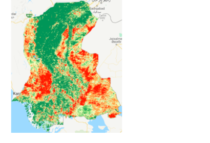
VHI Result Example

UN-SPIDER's Regional Support Office of Pakistan (SUPARCO) has provided a new Recommended Practice, using Google Earth Engine to identify the drought extent and severity by calculating different indices.

Drought is a slow on-set disaster which affects agriculture and associated livelihood in many parts of the world. It causes stress to vegetation; hence the extent of a drought can be reflected by changes in the vegetation condition. Geospatial scientists have developed drought indices based on remote sensing data to effectively detect drought conditions.

Droughts make considerable effects on agricultural and agro-pastoral areas due to their substantial dependency on rainfall. Agricultural drought monitoring is very important to maintain food security in the world. Satellite remote sensing is widely used for vegetation health monitoring and has become a powerful drought detection approach, because of its use at the global level. Indices have been developed using remote sensing data like the Normalized Difference Vegetation Index (NDVI), Land Surface Temperature (LST), Vegetation Condition Index (VCI), and Vegetation Health Index (VHI). These are employed to onset and monitor the agriculture drought in the relation to the plant growth.

The recommended practice is prepared to monitor and perform early warning of agriculture drought and can be easily adapted using Google Earth Engine.

Find further information, details, and a step-by-step explanation on the page of the Recommended Practice.
https://un-spider.org/advisory-support/recommended-practices/recommended-practi…
Fri, 20 May 2022 - 16:47
Drought
Pakistan Regional Support Office

Footer menu

  • Contact
  • Terms of Use

User account menu

  • Log in