  • English
  • Español
  • Français

United
Nations


Office for Outer Space Affairs
UN-SPIDER Knowledge Portal

  • Accueil
  • À propos
    • Qu'est-ce que l'ONU-SPIDER?
    • À propos d’UNOOSA
    • Publications
    • Offres d'emploi
    • Rencontrez l'équipe
    • Contact
  • Applications spatiales
    • Technologie satellitaire
    • Mécanismes d’urgence
    • Recovery Mechanisms
    • Réseau international d'alerte aux astéroïdes
    • Space Mission Planning Advisory Group
    • Initiative internationale sur la météorologie spatiale
    • Les technologies spatiales à l'ONU
    • Comptes-rendus d'utilisateurs
  • Liens & ressources
    • Application de données du mois
      • Disaster Recovery
    • Sources de données
    • SIG et logiciels de télédétection
    • Online Learning Resources
    • Institutions
  • Risques & catastrophes
    • Prévention des risques de catastrophe
    • Systèmes d'alerte précoce
    • Gestion des catastrophes et des interventions d'urgence
    • Aléas naturels
    • Cadre d'action de Sendai
    • L'ONU et la prévention des risques de catastrophe
    • L'ONU et les alertes précoces
    • L'ONU et la gestion des catastrophes
  • Appui technique
    • Missions Conseil
    • Appui d’urgence
    • Appui à distance
    • Pratiques recommandées
    • Activités de formation
    • Utilisations pratiques
  • Réseaux
    • Bureaux régionaux d’appui
    • GP-STAR
    • MHEWS
    • IWG-SEM
  • Projets
    • SPEAR
    • SEWS-D
    • EvIDENz
    • Flood GUIDE
  • Actualités
    • Actualités
    • Événements
    • Événements passés

Breadcrumb

  • Home
  • Goafen-3
  • Goafen-3

Goafen-3

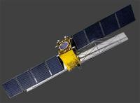
Gaofen-3 was launched into orbit on August 10, 2016 from Taiyuan Satellite Launch Center in China. It was developed by the China Center for Resources Satellite Data and Application (CRESDA). Gaofen-3 orbits at 755 km above the earth's surface and is fitted with a Synthetic Aperture Radar (SAR) sensor that makes use of microwaves in the electromagnetic C-band. The spatial resolution of its imagery ranges between 1 and 500 meters. The data collected by Gaofen-3 helps monitor climatological disasters (droughts) and hydrological disasters (landslides and floods).

10 Aug 2016
8years
Sun synchronous
Synthetic Aperture Radar
CRESDA
Earth observation and emergency management with an C-band SAR.
Sécheresse
Glissement de terrain
Inondation
C-Band active Radar
No
Information about Gaofen-3 on ESA's Earth Observation Portal

Footer menu

  • Contact
  • Terms of Use

User account menu

  • Log in