Risk management of storm surges requires knowledge on the temporal and geographic characteristics of storm surges, i.e. storm surge hazard maps; and information on the type of elements which are exposed and their vulnerability. Due to their strong wind speeds at sea, tropical storms or cyclones often generate storm surges that affect coastal communities when they reach land. The coastal inundation triggered by storm surges depends on the strength of the tropical cyclone and local conditions (bathymetry up to the coast and elevation above sea level). The presence of infrastructure, as well as estuaries and other coastal bodies may also play a role in the geographical extension of the coastal flooding.
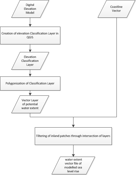
Often, high resolution data on bathymetry in coastal areas may not be available. So, it is not possible to use traditional hydraulic models to elaborate a precise estimation regarding coastal flooding in a specific area of a coast. In addition, in many developing countries there is no systematic record of the geographical extent of inundation of coastal areas due to storm surges which could be used to develop a statistical model. Therefore, high-resolution Digital Elevation Models (DEM) may be used as a first approximation to model the potential geographical extent of such coastal flooding.
This Recommended Practice allows users to visualize the geographical extent of coastal flooding or sea level rise on local, regional or global scale (depending on the resolution and accuracy of the incoming digital elevation model). The combination of the results of this Recommended Practice with data on the location of exposed elements, their degree of vulnerability and fragility can be used for an initial estimation of risk and to elaborate potential scenarios of impact of storm surges in specific geographic locations in coastal areas.
Computer Requirements
To perform the step-by-step procedure, it is required to install Quantum GIS (3.6.0-Noosa or newer version).
Required Datasets
Digital Elevation Model (e.g. WorldDEMTM a product of Airbus Defence and Space, please refer to this website for the study area
Coastline vector (e.g. WorldDEMTM Ocean Shoreline a product of Airbus Defence & Space, please refer to this website for further information
In case you want to test the Recommended Practice with WorldDEMTM data, please get in contact with Airbus through the contacts mentioned on the overview page.
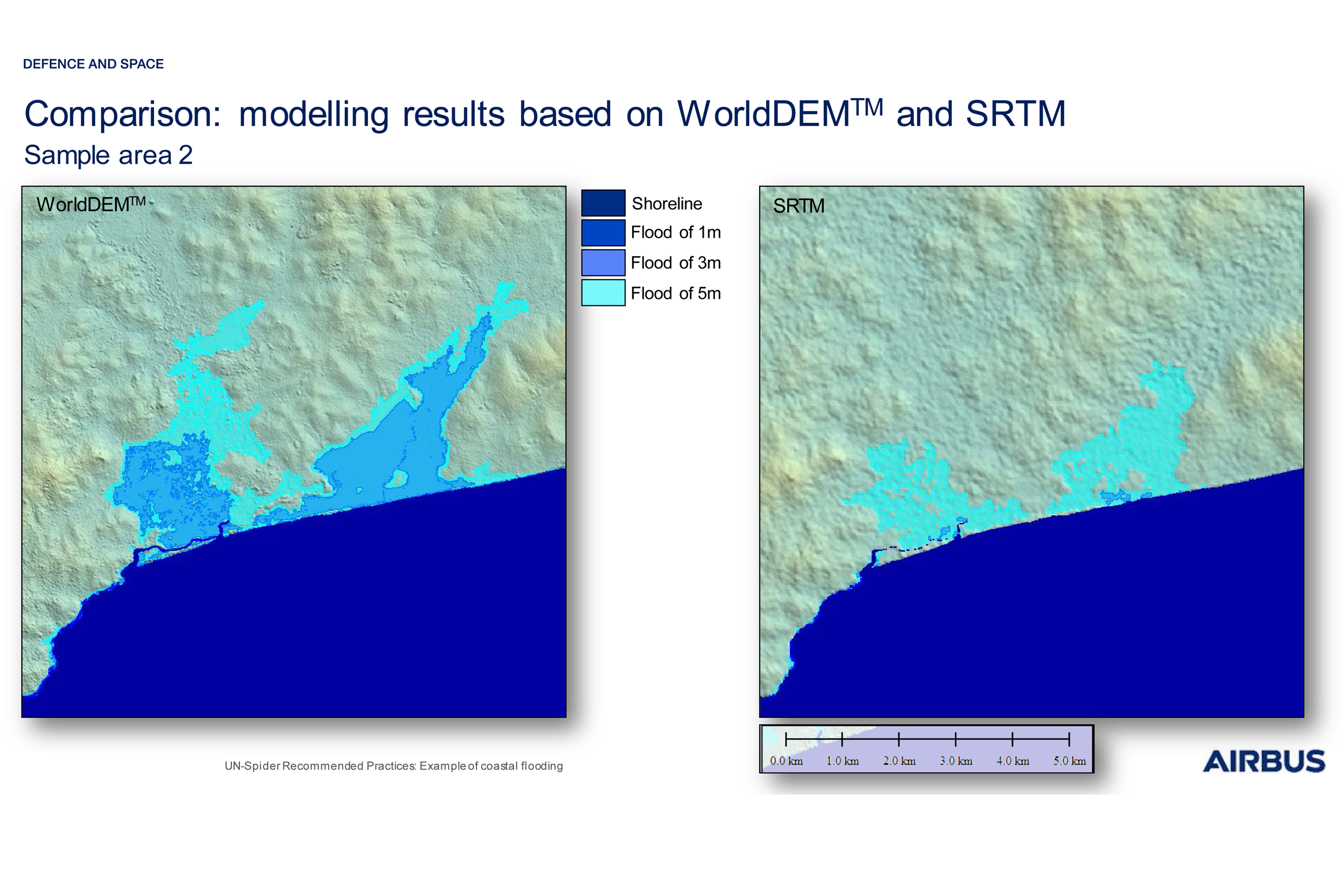
The precision and reliability of the results of modelling strongly depend on the quality and resolution of the Digital Elevation Model (DEM) used as basis for the analysis. The high resolution and level of detail provided by WorldDEMTM data allows an accurate delineation of the water distribution and of potential water streams between structures and buildings.
The Airbus Defence and Space elevation data WorldDEMTM is more sensitive to the distribution of water than the SRTM DEM: the use of the WorldDEMTM can lead to a more precise estimation of the effect of coastal flooding caused by e.g. storm surges or tidal waves.
Figure 1: Comparison between WorldDEMTM results vs SRTM results. SRTM shows completely different results.
Develop scenarios of impacts of storm surges in specific coastal areas;
Conduct an initial assessment of risk associated with storm surges;
Improve storm surge early warning systems using scenarios of the extent of coastal flooding.
Strengths:
Can be used in all coastal areas of the world, the WorldDEMTM data is available globally
Free and open-source software can be used (e.g. Quantum GIS)
WorldDEMTM:
Resolution: 0.4 arcsec (approx. 12m)
Absolute vertical accuracy: < 4m (90% linear error)
The WorldDEMTM data is globally available. However, for some regions there are restrictions regarding geographic availability. Consult with Airbus Defence and Space to determine whether data can be supplied for your region of interest.
Airbus Defence and Space (2018): WorldDEM™ Technical Product Specification. Issue 1.0, Version 2.4. July 2018. Available at: https://www.intelligence-airbusds.com/files/pmedia/public/r51492_9_2019-04_worlddem_technicalspecs_version2.5_i1.0.pdf
World Meteorological Organization (2011). Guide to Storm Surge Forecasting. Publication No. 1076. Geneva, Switzerland, 2011. Available at: https://library.wmo.int/pmb_ged/wmo_1076_en.pdf
DLR Document: TD-GS-PS-0021 (2016). TanDEM-X Ground Segment - DEM Products Specification Document, Issue 3.1, 05.08.2016. Available at https://tandemx-science.dlr.de/pdfs/TD-GS-PS-0021_DEM-Product-Specification_v3.1.pdf
Recommended Practices Step
Related Practices
Related data
Related Software
Disclaimer:
Neither UN-SPIDER nor the Regional Support Offices (RSOs) or their partners take any responsibility for the correctness of outputs from this recommended practice or decisions derived as a consequence.