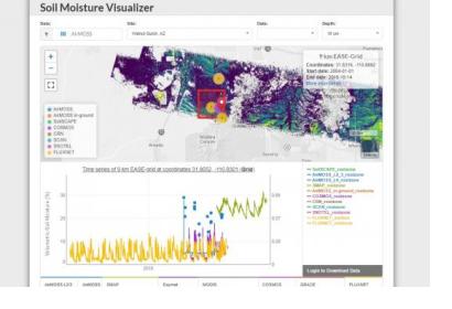
An integrated data platform has been created to bring together a wide variety of in situ and remotely-sensed soil moisture data sets to better inform disaster response planners, climate scientists and meteorologists, farmers, and others. The Soil Moisture Visualizer (SMV) is provided as an open and free data access tool from the NASA Oak Ridge National Laboratory Distributed Active Archive Center (ORNL DAAC).
Accurate and timely information on soil moisture is critical for research in agriculture, flooding, forest health, water quality, and modeling of the global carbon and water cycles, as well as being able to alert farmers to crop stress.
Data from in situ sensor networks have high temporal and spatial resolution, however they cover limited areas, whereas remote sensing and data assimilation methods provide information across broad spatial scales, but with higher uncertainty. Combining data from multiple sources helps to calibrate and validate the data and reduce uncertainty, and fills spatial and temporal gaps in soil moisture measurements.
The SMV allows users to explore potential relations between soil moisture and other relevant parameters, such as temperature, vegetation, and drought, within the web application. It also relies on a set of custom Python language scripts creating standardized comma-separated value (CSV) files for download.
The SMV currently includes data from major in situ networks, including the Soil Moisture Sensing Controller and Optimal Estimator (SoilSCAPE), the Cosmic-ray Soil Moisture Observing System (COSMOS), the National Oceanic and Atmospheric Administration’s U.S. Climate Reference Network and many more.
The goal of this system is to reduce the burden on scientists and stakeholders who want to find and use soil moisture data, but accomplishing this goal will require more work, as many geographic areas have gaps in the data from in situ network.
Currently, the SMV is limited to North America, but expanding it globally would serve more applications and the system would be enhanced by adding more data products, such as remote sensing data. It is anticipated that as the volume and variety of soil moisture data sources continue to expand, the user community will need easy-to-use tools like the SMV to preview, select, subset, harmonize, and download data.

