• English
  • Español
  • Français

United
Nations


Office for Outer Space Affairs
UN-SPIDER Knowledge Portal

  • Accueil
  • À propos
    • Qu'est-ce que l'ONU-SPIDER?
    • À propos d’UNOOSA
    • Publications
    • Offres d'emploi
    • Rencontrez l'équipe
    • Contact
  • Applications spatiales
    • Technologie satellitaire
    • Mécanismes d’urgence
    • Recovery Mechanisms
    • Réseau international d'alerte aux astéroïdes
    • Space Mission Planning Advisory Group
    • Initiative internationale sur la météorologie spatiale
    • Les technologies spatiales à l'ONU
    • Comptes-rendus d'utilisateurs
  • Liens & ressources
    • Application de données du mois
      • Disaster Recovery
    • Sources de données
    • SIG et logiciels de télédétection
    • Online Learning Resources
    • Institutions
  • Risques & catastrophes
    • Prévention des risques de catastrophe
    • Systèmes d'alerte précoce
    • Gestion des catastrophes et des interventions d'urgence
    • Aléas naturels
    • Cadre d'action de Sendai
    • L'ONU et la prévention des risques de catastrophe
    • L'ONU et les alertes précoces
    • L'ONU et la gestion des catastrophes
  • Appui technique
    • Missions Conseil
    • Appui d’urgence
    • Appui à distance
    • Pratiques recommandées
    • Activités de formation
    • Utilisations pratiques
  • Réseaux
    • Bureaux régionaux d’appui
    • GP-STAR
    • MHEWS
    • IWG-SEM
  • Projets
    • SPEAR
    • SEWS-D
    • EvIDENz
    • Flood GUIDE
  • Actualités
    • Actualités
    • Événements
    • Événements passés
  • Admin
    • SAM Items

Breadcrumb

  • Home
  • Using New Techniques In Greece To Track The Effects of Flooding
  • Using new techniques in Greece to track the effects of flooding

Using new techniques in Greece to track the effects of flooding

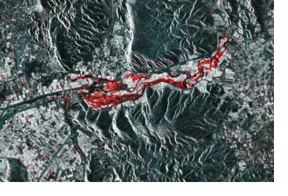
The Sentinel-1 RGB stack showing (in red) flooding on February 23, 2018. Image: Sentinel PlaygroundThe Sentinel-1 RGB stack showing (in red) flooding on February 23, 2018. Image: Sentinel Playground

Greek Geographic Information Systems company Geospatial Enabling Technologies (GET) has tested a new crisis management solution based on services rendered through the Copernicus Sentinel Hub after flooding in Farkadona, Greece.

The Copernicus Sentinel Hub, set up by the European Commission and European Space Agency, is a service that provides quick and up-to-date satellite information to be used by authorities. Through the Sentinel-1 satellite in particular, they use radar to track differences between flooded and dry land through before and after images.

In late February, flooding and landslides caused by heavy rainfall affected the Farkadona municipality in central Greece, leading to evacuations and loss of farmland in the region. In response, GET used imagery produced by the Sentinel-1 satellite in a prototypical algorithm that uses the Sentinel Application Platform (SNAP) and Open Geospatial Consortium (OGC) to produce data sets. This data provided a complete and comprehensive covering of the floods, giving authorities the information they needed to better respond and prepare in the future.

To support authorities in mapping hazards, UN-SPIDER , together with its Regional Support Offices and other partners, has developed a set of step-by-step procedures for obtaining, processing and mapping space-based data, for instance for floods or droughts . The Recommended Practices are available online.
Greece: The use of satellite imagery in crisis management after flooding
Mon, 30 Apr 2018 - 11:06
Greece
Flood

Footer menu

  • Contact
  • Terms of Use

User account menu

  • Log in