 |
 |
 |
 |
Agriculture is the immediate victim of drought disaster, which impacts the crop area, crop production and farm employment and severe implications for the affected population. Drought is the most complex and least understood of all disasters and differs from other natural hazards in many respects. According Hisdal and Tallaksen (2000) scientists have agreed on general definitions of drought. According to Beran & Rodier (1985), “The chief characteristic of a drought is a decrease of water availability in a particular period over a particular area." This definition highlights three features of a drought: intensity, duration and spatial coverage. Yevjevich (1967) claims that the lack of general acceptance of a precise and objective definition of drought, has been one of the principle obstacles to the investigation of drought”. There are three three types of droughts, namely;
- Meteorological drought: related to rainfall amounts
- Hydrological drought: determined by water levels in reservoirs
- Agricultural drought: related to the availability of water for crops
Traditionally, Drought Early Warning Systems (DEWS) are operated by meteorological observatories or institutes in countries of this region using rainfall data (rainfall anomalies). The Standardized Precipitation Index is being promoted for such purposes. Ministries of Agriculture often use their extensionists in the field to gather additional data and information on the impacts of droughts and as a way to generate an overall picture regarding the extent of droughts and their potential impacts. However, there is no real use of space-based information to track changes in the condition of the vegetation as a way to complement rainfall anomaly data in order to enhance the scope and effectiveness of the DEWS.
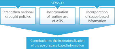
Considering the fact that traditional DEWS in these regions rely on rainfall data anomalies and on the observations gathered at specific places by the employees of ministries of agriculture and local authorities; the SEWS-D project aims to strengthen such early warning systems through the strengthening of national drought policies and the incorporation of the routine use of the information generated through the use of the Agricultural Stress Index System (ASIS) which has been developed by the Food and Agriculture Organization of the United Nations (FAO), information by the International Centre for the Research of El Niño Phenomenon (CIIFEN in its Spanish acronym), and the use of additional space-based information. In particular through the incorporation of the use of indexes based on satellite products such as the Normalized Differential Vegetation Index (NDVI), the Enhanced Vegetation Index (EVI), the Vegetation Condition Index (VCI), the Vegetation Health Index (VHI) and the Vegetation Anomaly Index (VAI); as well as soil-moisture. The reasons that justify the use of such indexes include:
- These indexes address vegetation as a vulnerable element, thus complementing the observations on rainfall deficit that are related to the drought hazard;
- Several of these indexes are calculated from satellite composite products that are available free of charge and using either open-source or commercial software;
- As of May 2016, FAO will provide access to the version of ASIS which has been tailored to be used at the level of countries for the generation of the VHI;
- These products cover the whole country and possess an appropriate resolution for the needs of ministries and food security and nutrition commissions or committees.
SEWS-D partners provide technical advisory support to the government agencies in the countries where the project is implemented. Regional and national training activities facilitate the incorporation of the use of space-based information, while outreach efforts at regional and international events raise awareness about the benefits of satellite composite products.
Once implemented, the project will allow decision makers to visualise the effects of droughts on the vegetation in different regions of their countries. Operators of the DEWS will become aware of the severity of current droughts in comparison with historical droughts which took place in the last 15 to 30 years. Finally, SEWS-D supports decision makers in identifying measures as a way to cope with the effects of such droughts.
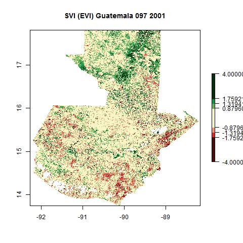
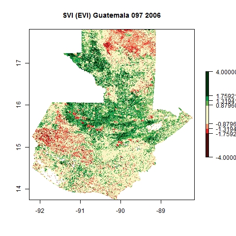
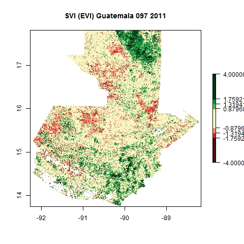
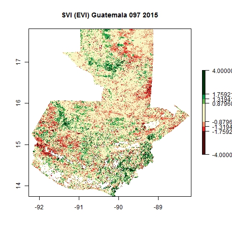
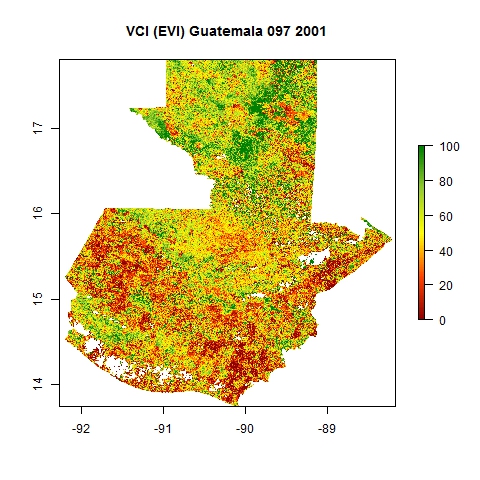
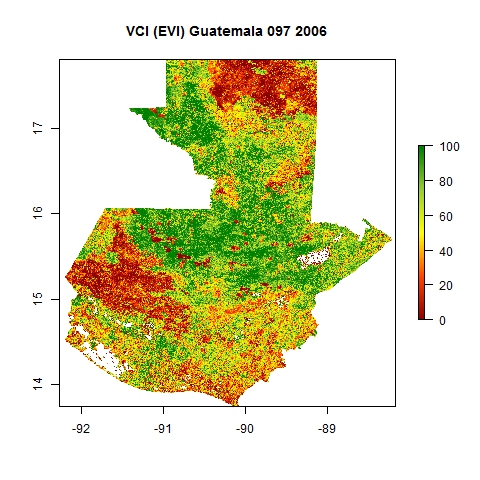
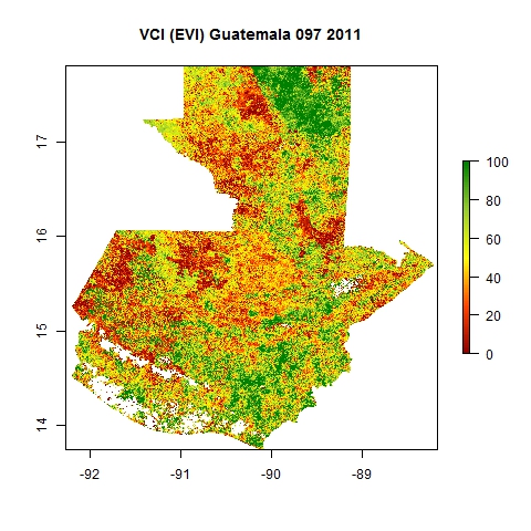
Examples of products developed
Comparison of SVI and VCI maps for Guatemala for Julian day 97 corresponding to four distinct years using EVI composite products from MODIS.
SVI |
2001
|
2006
|
2011
|
2015
|
VCI |
2001
|
2006
|
2011
|
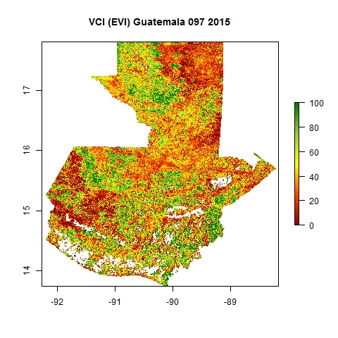
2015
|