• English
  • Español
  • Français

United
Nations


Office for Outer Space Affairs
UN-SPIDER Knowledge Portal

  • Accueil
  • À propos
    • Qu'est-ce que l'ONU-SPIDER?
    • À propos d’UNOOSA
    • Publications
    • Offres d'emploi
    • Rencontrez l'équipe
    • Contact
  • Applications spatiales
    • Technologie satellitaire
    • Mécanismes d’urgence
    • Recovery Mechanisms
    • Réseau international d'alerte aux astéroïdes
    • Space Mission Planning Advisory Group
    • Initiative internationale sur la météorologie spatiale
    • Les technologies spatiales à l'ONU
    • Comptes-rendus d'utilisateurs
  • Liens & ressources
    • Application de données du mois
      • Disaster Recovery
    • Sources de données
    • SIG et logiciels de télédétection
    • Online Learning Resources
    • Institutions
  • Risques & catastrophes
    • Prévention des risques de catastrophe
    • Systèmes d'alerte précoce
    • Gestion des catastrophes et des interventions d'urgence
    • Aléas naturels
    • Cadre d'action de Sendai
    • L'ONU et la prévention des risques de catastrophe
    • L'ONU et les alertes précoces
    • L'ONU et la gestion des catastrophes
  • Appui technique
    • Missions Conseil
    • Appui d’urgence
    • Appui à distance
    • Pratiques recommandées
    • Activités de formation
    • Utilisations pratiques
  • Réseaux
    • Bureaux régionaux d’appui
    • GP-STAR
    • MHEWS
    • IWG-SEM
  • Projets
    • SPEAR
    • SEWS-D
    • EvIDENz
    • Flood GUIDE
  • Actualités
    • Actualités
    • Événements
    • Événements passés

Breadcrumb

  • Home
  • Review: The Partnership of EROS And The UN
  • Review: the partnership of EROS and the UN

Review: the partnership of EROS and the UN

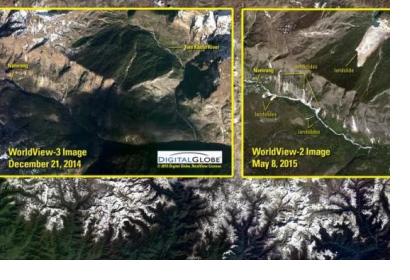
Remote sensing imagery, like here showing the earthquake and landslides in Nepal 2015, provide important information (Image: USGS).Remote sensing imagery, like here showing the earthquake and landslides in Nepal 2015, provide important information (Image: USGS).

The Earth Resources Observation and Science (EROS) Center, one of the facilities of the Unites States Geological Survey (USGS) of the United States, was established in the early 1970s as the center to manage remotely sensed data, to develop ground systems for satellite missions and to conduct research on the potential applications of such remotely sensed data.  Through such efforts, the EROS Center contributes to the global understanding of how changes in land use, cover, and condition affect people and nature.

Since 1991, the EROS Center has hosted the North American Global Resource Information Database of the United Nations Environment Programme (UNEP/GRID). Through such an initiative, the EROS Center has provided space satellite imagery to many of the UN Member States for more than four decades. EROS mandate prioritizes the permanent review of the world environmental situation as a way to inform UN Member States on the state of environment. 

Satellite imagery has been especially valuable for developing countries, which often face severe consequences of natural disasters and climate change. Mr. Frank Kelly, the Director of the EROS Center, described the partnership with the UN, "They wanted to be close to where the data was and see if there was a way they could optimize their expenses and their resources, plus the expertise of people that we had here at EROS.  It was just one of those things that worked in terms of the U.N. looking for somewhere." 

Over the last years scientists from more than a dozen UN Member States have visited the EROS Data Center near Garretson, South Dakota. The scientific collaboration between scientists from these Member States and those from the EROS Center has allowed for an improved understanding of what is going on in such Member States using the data provided by the Center. 
Read more: Earth Resources Observation and Science (EROS) Center
EROS: U.N.'s Satellite Office
Wed, 4 Nov 2015 - 13:39
United States of America

Footer menu

  • Contact
  • Terms of Use

User account menu

  • Log in