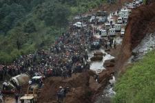
At around 11 PM on the night of 1st October 2015, a landslide took place in the Santa Catarina municipal district of the greater metropolitan district of Guatemala City. The landslide affected an urban settlement called El Cambray 2. The National Coordinating Agency for Disaster Reduction of Guatemala (CONRED) activated its National Emergency Operations Center early in the morning on 02 October. As of 10:00 AM on 6th October, the number of fatalities had risen to 161. CONRED estimates that there are still between 400 and 500 persons missing, as the landslide affected nearly 125 houses.
Search and rescue efforts continue with the aid of specialized rescue teams from Mexico and heavy machinery. Local experts are conducting assessments to determine the susceptibility to landslides of neighbouring areas and to identify ways to stabilize the ground. A local command post was established by municipal authorities and CONRED to coordinate inter-institutional efforts on 02 October and temporary shelters have been set up to accommodate those affected.
Digital Globe has contributed through the provision of archived and up-to-date satellite imagery to contribute to response efforts.
Links to data and maps:
- Map of the affected area provided by CONRED (link)
- Link to the activation page of the International Charter on space and Major Disasters
- Digital Globe Browse images of 4 October 2015: Center Lat/Long: 14.575°/-90.506°, Center Lat/Long: 14.582°/-90.492°, Center Lat/Long: 14.578°/-90.482°, Center Lat/Long: 14.567°/-90.512°
- Pre- and post-disaster WORLDVIEW2 data and post-disaster SPOT6 data can be browsed via USGS's Hazard Data Distribution System (HDDS). A Landsat8 scene of 4 August 2015 can be directly downloaded from HDDS, commercial high-resolution data can be downloaded with a special user account that can be requested directly via HDDS.
- Sentinel-1 SAR image (VV) of 10 October 2015 (Link to Sentinels Scientific Data Hub)
Additional useful links
- UN-SPIDER Technical Advisory Mission to Guatemala (2010) - including links to relevant institutions in the country (link)
- UN-SPIDER expert mission to Guatemala (2010) (link)
- UN-SPIDER expert mission to Guatemala (2011) (link)
- UN-SPIDER data application of the month on landslides (link)
- UN-SPIDER data application of the month on emergency response (link)
- UN-SPIDER data application of the month on free satellite data (link)
- UN-SPIDER database on data sources, which can be filtered for "Disaster Cycle Phase - Response" and "Hazard Type - Mass Movement" (link)
- International Working Group on Satellite-based Emergency Mapping, IWG-SEM (link)
- Emergency Mechanisms (link)
New Updates
- Guatemala: Search of Missing People due to Landslide Brought to Close (link)
- Search in Guatemala landslide ends with 280 dead, 70 missing (link)
- Guatemala Landslide Death Toll Reaches 280 (link)
- Guatemala mudslide death toll climbs to 237: Official (link)
- Guatemala landslide: 191 confirmed dead, 08 October 2015 (link)
- UN suggests corruption behind Guatemala disaster, 08 October 2015 (link)