![]()
United
Nations
Éclatement du lac glaciaire

Definition
Facts and figures
Further information
UN-SPIDER Regional Support Offices with hazard-specific expertise
Related content on the Knowledge Portal

 The Copernicus DEM is a Digital Surface Model (DSM) which represents the surface of the Earth including buildings, infrastructure, and vegetation. The Copernicus DEM is provided in 3 different instances. Two worldwide coverages at 90m (GLO-90) and 30m (GLO-30) resolution are openly available to the public for download via the PANDA Catalogue and FTP. A further European coverage (EEA-10) is provided at 10m resolution, but data is restricted to eligible users who meet required access rights.Publishing institution:
-
The Copernicus DEM is a Digital Surface Model (DSM) which represents the surface of the Earth including buildings, infrastructure, and vegetation. The Copernicus DEM is provided in 3 different instances. Two worldwide coverages at 90m (GLO-90) and 30m (GLO-30) resolution are openly available to the public for download via the PANDA Catalogue and FTP. A further European coverage (EEA-10) is provided at 10m resolution, but data is restricted to eligible users who meet required access rights.Publishing institution:
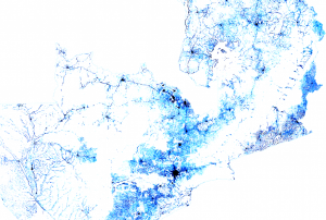 Facebook Connectivity Lab in collaboration with the Center for International Earth Science Information Network (CIESIN) at Colombia University combines machine vision AI with satellite imagery and census information to create population density maps. With the integration of demographic information, specifically related to age and gender, these maps collectively provide information on both the location and the demographic of a population in a certain country. The population density maps cover the majority of countries around the world.Publishing institution:
-
Facebook Connectivity Lab in collaboration with the Center for International Earth Science Information Network (CIESIN) at Colombia University combines machine vision AI with satellite imagery and census information to create population density maps. With the integration of demographic information, specifically related to age and gender, these maps collectively provide information on both the location and the demographic of a population in a certain country. The population density maps cover the majority of countries around the world.Publishing institution:

Natural lakes and man-made reservoirs are a part of Earth’s surface water. Freshwater lakes and reservoirs are used for drinking water, fishing, and recreational activities. Aside from the aesthetic and scenic value added by their presence, lakes support surrounding plant and aquatic ecosystems and wildlife. A variety of factors affect lakes and reservoirs, including climate variability and change, land use, and other watershed activities influencing surface runoff and groundwater. Therefore, monitoring the water quantity and quality of lakes and reservoirs is crucial for their sustainable management. This training focuses on introducing remote sensing observations for monitoring the water level of lakes; a critical surface water component affecting the residential, economical, and recreational sectors in the area. Recent observations of lake bathymetry based on remote sensing observations will also be presented.
Course Format
The online…
read more
The United Nations Office for Outer Space Affairs (UNOOSA) and the National Aeronautics and Space Administration of the United States Government (NASA) signed a landmark Memorandum of Understanding (MoU) on 17 December 2020 pledging cooperation in areas of science and technology to support the peaceful uses of outer space.
The MoU brings together NASA's wealth of open-source spacecraft data, tools, and expertise and UNOOSA's unique position as the only UN entity dedicated to outer space affairs, to expand global opportunities to leverage the benefits of space. The partners will design capacity-building programmes, particularly for institutions in countries that do not yet have or that are developing space capabilities, to help them access space.
Together, UNOOSA and NASA will develop ways to leverage the Artemis programme as part of UNOOSA's Access to Space 4 All Initiative, which offers opportunities for international researchers and institutions, especially in…
read more11/01/2021
A new report by the world’s largest humanitarian aid network highlights global disasters, populations most vulnerable to them and the efforts of local institutions in preventing, preparing for and responding to them. The 2020 edition of the World Disasters Report, “Come Heat or High Water”, was launched virtually from the offices of the International Federation of Red Cross and Red Crescent Societies (IFRC) in Vienna on November 16. This year’s report discusses climate- and weather-related disasters and their humanitarian impact. It argues for the usefulness of smart financing and space-based information in disaster management support.
The report warns that the global effort to address climate change is leaving behind countries…
read more19/11/2020
Officially launched in 2015 by the National Aeronautics and Space Administration (NASA), the SMAP mission is an orbiting satellite that measures the amount of wetness in the top layer of soil incrementally every 2-3 days. These Soil Moisture Active Passive (SMAP) measurements rely on radiation frequencies that point to different levels of moisture on the surface of earth’s soil and are useful for scientists because it allows them to construct maps indicating the level of soil moisture globally. Acknowledging the relevance and usability of this data for the field of disaster management, NASA recently integrated the SMAP data into its Disasters Mapping Portal.
The Disasters Mapping Portal has been developed by the Geographic Informations Systems (GIS) Team at NASA in an effort to make their satellite data…
read more25/11/2020
The European Commission plans to rapidly expand its environmental monitoring programme Copernicus. For this purpose, the European Space Agency (ESA) recently pledged 2.55 billion Euros towards contracts to advance the production of six new Copernicus satellite missions. The final of the six contracts was signed last Thursday between ESA and Thales Alenia Space for a mission that will provide new and important information to climate research and disaster management.
The high-priority Copernicus Radar Observation System for Europe in L-band (ROSE-L) mission is planned to launch in 2028 for a period of 7.5 years. The ROSE-L mission will orbit Earth every few days at an altitude of 690km and will carry a L-Band synthetic aperture radar (SAR). With a wavelength of approximately 23cm, an…
read more18/12/2020
Term Parents
UN-SPIDER Regional Support Offices with hazard-specific expertise
![]()