• English
  • Español
  • Français

United
Nations


Office for Outer Space Affairs
UN-SPIDER Knowledge Portal

  • Accueil
  • À propos
    • Qu'est-ce que l'ONU-SPIDER?
    • À propos d’UNOOSA
    • Publications
    • Offres d'emploi
    • Rencontrez l'équipe
    • Contact
  • Applications spatiales
    • Technologie satellitaire
    • Mécanismes d’urgence
    • Recovery Mechanisms
    • Réseau international d'alerte aux astéroïdes
    • Space Mission Planning Advisory Group
    • Initiative internationale sur la météorologie spatiale
    • Les technologies spatiales à l'ONU
    • Comptes-rendus d'utilisateurs
  • Liens & ressources
    • Application de données du mois
      • Disaster Recovery
    • Sources de données
    • SIG et logiciels de télédétection
    • Online Learning Resources
    • Institutions
  • Risques & catastrophes
    • Prévention des risques de catastrophe
    • Systèmes d'alerte précoce
    • Gestion des catastrophes et des interventions d'urgence
    • Aléas naturels
    • Cadre d'action de Sendai
    • L'ONU et la prévention des risques de catastrophe
    • L'ONU et les alertes précoces
    • L'ONU et la gestion des catastrophes
  • Appui technique
    • Missions Conseil
    • Appui d’urgence
    • Appui à distance
    • Pratiques recommandées
    • Activités de formation
    • Utilisations pratiques
  • Réseaux
    • Bureaux régionaux d’appui
    • GP-STAR
    • MHEWS
    • IWG-SEM
  • Projets
    • SPEAR
    • SEWS-D
    • EvIDENz
    • Flood GUIDE
  • Actualités
    • Actualités
    • Événements
    • Événements passés

Breadcrumb

  • Home
  • Taxonomy Pages
  • Taxonomy Pages

Croatia

country taxonomy block

EU Copernicus Mapping Services produces maps for floods in Balkan states
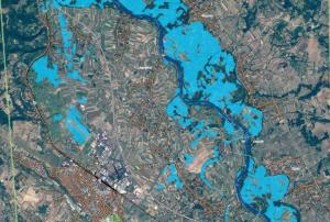
Extent of floods near Jagodina, Serbia on 15 May 2014

The Emergency Mapping Service of the European Union's Copernicus programme was activated to provide satellite-based maps of the severe floods in Croatia, Bosnia and Herzegovina, and Serbia.

The service produced four maps for Croatia, 18 maps for Bosnia and Herzegovina, and 20 maps of Serbia.

NASA's Earth Observatory has also published a satellite image of the floods in Croatia, Serbia, and Bosnia and Herzegovina on May 19, 2014. By comparing the current image to an image from 18 May 2013, the massive extent of the floods becomes clearly visible.

Due to heavy rains…

more
Publishing date 20/05/2014
Croatia

Contact Person
Mr. Mladen Cvrlje
Tel. +385 1 4569 893
Email: mcvrlje@mvpei.hr

Footer menu

  • Contact
  • Terms of Use

User account menu

  • Log in