• English
  • Español
  • Français

United
Nations


Office for Outer Space Affairs
UN-SPIDER Knowledge Portal

  • Inicio
  • Sobre nosotros
    • Sobre ONU-SPIDER
    • Acerca de UNOOSA
    • Publicaciones
    • Ofertas de trabajo
    • Conozca el Equipo
    • Contacto
  • Aplicación Espacial
    • Guías Tecnológicas
    • Mecanismos de Emergencia
    • Mecanismos de Recuperación
    • Red Internacional de Alerta de Asteroides
    • Grupo Asesor para la Planificación de Misiones Espaciales
    • Iniciativa Internacional sobre Meteorología Espacial
    • Tecnologías Espaciales en la ONU
    • Historias de Usuarios
  • Enlaces y Recursos
    • Aplicación de datos del mes
      • Disaster Recovery
    • Fuentes de Datos
    • SIG y Software de Percepción Remota
    • Recursos de capacitación en línea
    • Instituciones
  • Riesgos y Desastres
    • Gestión del Riesgo de Desastres
    • Alerta temprana
    • Gestión de Desastres y Emergencias
    • Amenazas Naturales
    • El Proceso de la Reducción de Desastres Post-2015
    • La ONU y la Gestión del Riesgo de Desastres
    • La ONU y Alerta Temprana
    • La ONU y la Gestión de Desastres
  • Asesoría
    • Misiones de Asesoría
    • Apoyo en caso de Emergencia
    • Asesoría Virtual
    • Prácticas Recomendadas
    • Actividades de Entrenamiento
    • Usos Prácticos
  • Redes
    • Oficinas Regionales de Apoyo
    • GP-STAR
    • IN-MHEWS
    • IWG-SEM
  • Proyectos
    • SPEAR
    • FOSAT-S
    • EvIDENz
    • Flood GUIDE
    • CommonSpace Initiative
  • Noticias y Eventos
    • Noticias
    • Eventos
    • Eventos pasados

Breadcrumb

  • Home
  • Viet Nam And India Cooperate In Remote Sensing Technology
  • Viet Nam and India cooperate in remote sensing technology

Viet Nam and India cooperate in remote sensing technology

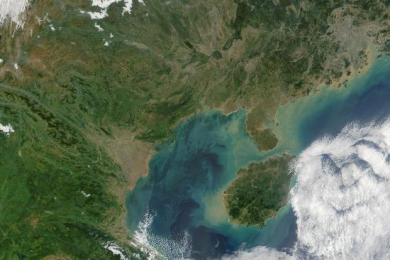
True color satellite image of the Gulf of Tonkin in Vietnam (Image: NASA)True color satellite image of the Gulf of Tonkin in Vietnam (Image: NASA)

The Vietnamese Ministry of Natural Resources and Environment and the Indian Department of Space will promote cooperation in remote sensing and outer space technology via joint projects in human resources training and in applying remote sensing technology.

According to an article in Vietnamplus, the two sides made the joint decision during working sessions between a delegation of the Vietnamese ministry, which made a three-day visit to India recently, and officials from India’s Ministry of External Affairs, Department of Space, and Space Research Organisation. 

Both are making preparations for establishing a centre for satellite tracking, data reception and processing for the Association of Southeast Asian Nations (ASEAN). The center will be located in Vietnam where Vietnamese personnel will be trained to operate the center. India will pay for the installation and operation costs for the project in the first five years, and supply remote sensing images free of charge to ASEAN member states for five years. 
Vietnam
Mon, 18 May 2015 - 16:08
India
Viet Nam

Footer menu

  • Contact
  • Terms of Use

User account menu

  • Log in