Recommended Practice: Flood Mapping with Radar Imagery and Digital Terrain Models
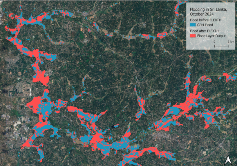
This recommended practice introduces a novel algorithm developed by the Joint Research Centre of the European Commission that combines SAR-derived flood layers with digital terrain models and the Global Flood Monitoring (GFM) exclusion mask. By leveraging Digital Terrain Models (DTMs), water depth calculations and hydrodynamic propagation models are applied to infer flood conditions within exclusion mask areas, enhancing the reliability of flood extent delineations.
The objective of this practice is to improve flood maps with DTMs. This is necessary, as Synthetic Aperture Radar (SAR) sensors are not sensible to flood water on every land surface / land use class equally. That is especially the case in urban and densely vegetated areas.
During this practice, flood delineations from GFM are used and improved. Furthermore, water depths are calculated for the flooded areas, which is valuable information for rapid response teams as well as for estimating economic loss. Water depth cannot be estimated by satellite-based flood mapping (Betterle and Salamon 2024).
In October 2024, many provinces of Sri Lanka have been experiencing heavy rainfall and strong winds, causing floods and severe weather-related incidents that resulted in casualties and damage (Sri Lanka: Floods - Oct 2024 | ReliefWeb, accessed: 22.11.2024).
Nepal, Sri Lanka and Bangladesh experience an increased flood risk and extend of the monsoon season from June to October, with heavier rainfall potentially disrupting agricultural activities and affecting infrastructure (OCHA, 19.11.2024).
This practice can be applied to flooding events globally. It requires little to no knowledge of GIS and Remote Sensing. A basic understanding of Python code and virtual environments in Python is helpful to the analysis but is no requirement.
Por favor tome nota que ni ONU-SPIDER ni las Oficinas Regionales de Apoyo o sus socios se responsabilizan por la calidad de los resultados que se obtienen usando esta práctica recomendad o las decisiones que se tomen con estos resultados.