![]()
United
Nations
OneAtlas (Airbus)
| Data provided by: | Airbus Defence & Space |
| Data accessibility: | Exportar datos, Visualización de datos (ej. web SIG o monitoreo en tiempo real), Procesamiento web/computación en la nube |
| Link to the data: | |
| File type: | GeoTIFF |
| Data type: | Línea base, Elevación, Datos sobre amenazas específicas, Datos sobre el use suelo, cobertura del terreno, Datos satelitales o imágenes aéreas |
| Hazard: | Volcanic Eruption, Earthquake, Flood, Severe Storm |
| Disaster cycle phase: | Gestión des Riesgo por Desastres, Respuesta, Recuperación |
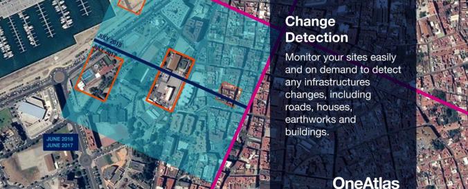
| Space-based Information: | OneAtlas is a collaborative environment to easily access very high resolution imagery, perform large-scale image processing, extract industry specific insights and benefit from Airbus assets to develop solutions. The services include infrastructure change detection, vehicle detection & counting and will soon cover aircraft detection and land use change detection as well . Airbus provides the services through a buy-what-you-need option. It is possible to test the functionalities with a 30-days Free Trial. |
| Satellites and Sensors: | Pléiades-1A, Pléiades-1B, SPOT 6, SPOT 7, TerraSAR-X |
| Spatial coverage: | Global |
| Spatial resolution: | 0.5-40 m |
| Temporal coverage: | Archivado, Casi en tiempo real |
| Content dates: | 2012-present |
| Technical Specifications: | |
| Costs: | Pagado |
| Contact: | Contact |
| Tutorials on the use of data: | How to use OneAtlas |
| Restrictions/ Citation of the dataset: |
Provider
![]()