Inundación
Definition
Facts and figures
Further information
UN-SPIDER Regional Support Offices with hazard-specific expertise
Related content on the Knowledge Portal
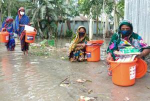
- In the latest example of anticipatory humanitarian action, the United Nations released $5.2 million from the Central Emergency Response Fund (CERF) to help communities in Bangladesh prepare themselves ahead of major monsoon floods. The allocation of funds to agencies in the country to prepare to deliver support was triggered by a forecast from the Global Flood Awareness System (GloFAS), which predicted areas having a greater than 50 per cent chance of experiencing a severe flood between 14 and 16 July. Following a second forecast by the Government’s Flood Forecasting... read more21/07/2020
To support emergency response efforts, the International Centre for Integrated Mountain Development (ICIMOD) has mapped the extent of floods in Bangladesh following Cyclone Amphan, which caused widespread damage in the country and neighboring India in mid-May. The maps are based on Sentinel-1 radar imagery. Radar satellite data is commonly used for flood mapping purposes due to its ability to make measurements irrespective of daytime and cloud cover of the scene.
By providing an overview of the extent of inundation caused by the floods, these maps are useful in the context of disaster management, as humanitarian agencies are able to detect areas that have been affected by the floods the most and can coordinate relief and rescue activities accordingly.
The tropical cyclone caused at least 96 deaths in Bangladesh and inflicted substantial damage to...
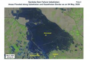
read moreRegional Support Offices mentioned:09/06/2020Using space-based information, the Centre for Space Science and Technology Education in Asia and the Pacific (CSSTEAP) affiliated to the United Nations has analysed the recent failure of a dam around the Sardoba Reservoir in Uzbekistan. Following a week of heavy rain in the region, the wall of the dam broke on 1 May and flooded surroundings in Uzbekistan as well as Kazakhstan to the north. According to media reports, the breach led to the evacuation of thousands of people in the area.
The analysis carried out by CSSTEAP makes use of MODIS multi-temporal satellite images to identify the maximum spread of the floods, which was observed on 2 May. Waters receded in the following days, although they are still visibile along the border between the two countries on imagery from 12 May.
With the help of Landsat 8 and...
read more19/05/2020The Japan Aerospace Exploration Agency (JAXA) has released the JAXA Climate Rainfall Watch website to monitor extreme weather and climate over the world. The website provides hourly global measurements of precipitation as well as forecasts about heavy rainfall and drought in different temporal scales (daily, pentad, weekly, 10-days and monthly). The satellite-based global rainfall maps produce highly accurate measurements that can help better understand the changing climate, improve forecasts of extreme weather events, such as floods and droughts, minimize their damage and strengthen early warning systems.
The Climate Rainfall Watch website monitors heavy rainfall and drought in near-real-time and collects and stores data from previous months. The website calculates rainfall in percentile: heavy rain is indicated by...
read more15/04/2020To support the National Office of Civil Protection (ONPC) of Tunisia and other government agencies in using space-based information for disaster management, UN-SPIDER conducted a three-day training in Tunis from 9 to 11 March. The course highlighted the relevance and usefulness of remote sensing and satellite data as a decision-making tool in risk and disaster management. It focused on the UN-SPIDER Recommended Practice for flood mapping with Sentinel-1 radar data to support authorities in responding to recurring floods in the country.
Twelve participants attended the event, which introduced them to remote sensing and provided an overview of synthetic-aperture radar (SAR) principles, before walking them step-by-step through downloading, processing and mapping data from the Sentinel-1 satellite using the free and open source software solutions SNAP and QGIS. The training also...
read more10/03/2020Scientists from 50 scientific institutions, led by the National Aeronautics and Space Administration (NASA) and the European Space Agency (ESA) combined 26 independent satellite datasets to show that the Greenland Ice Sheet melt is increasing. The group studied data from 1992 to 2018, taking direct measurements of the continent-sized glacier. The study found that decade averages for ice melt has increased sevenfold from the 1990s.
The report shows that 1992 to 2002 averaged 1mm/decade in melt, 2008 to 2018 increased to a 7mm/decade loss. The research pulled from USGS’s Landsat mission, the oldest open-access Earth observation data. The total was also calculated using space-based gravity measurements - which measures total mass on the world’s largest island - integrated with remotely sensed height...
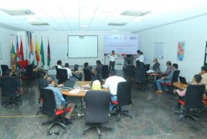
read more03/02/2020In order for South Asian Association for Regional Cooperation (SAARC) Member States to be able to incorporate the routine use of space technology-based solutions, there is a need to increase awareness, build national capacity and develop solutions that are customized to their needs. The regional workshop and capacity-building programme on the "Role of Earth Observation in Multi-Hazard Disaster Risk Assessment and Monitoring Targets of the Sendai Framework" is the second regional event in South Asia under the umbrella of the SAARC Disaster Management Center and the United Nations Office for Outer Space Affairs (UNOOSA), through its UN-SPIDER programme. The event took place in collaboration with the International Water Management Institute (IWMI), Sri Lanka, the Space Applications Centre of the Indian Space Research Organisation (ISRO) and the Centre for Space Science and Technology Education in Asia Pacific (CSSTEAP). It was built on the outcome of the first regional workshop and...
read moreRegional Support Offices mentioned:12/12/2019The 2019 rainy season in the Far North region of Cameroon has caused the Logone river to overflow and flood the Zina (Logone-et-Chari department), Maga and Kai-Kai districts (Mayo Dany) in the country's Far North region. The United Nations Office for the Coordination of Humanitarian Affairs reports that at least 60 out of 110 villages in the Zina district - 19,359 people - are affected, while 15 villages with a total of 16,215 people are affected in the Kai-Kai district.
UN-SPIDER has requested the activation of the International Charter Space and Major Disasters for the floods on behalf of the Department of Civil Protection (DPC) of Cameroon. SERTIT is acting as the project manager for this activation. An...
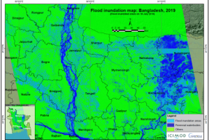
read more19/10/2019In July 2019, Bangladesh, India and Nepal experienced floods and landslides during the South Asian monsoon season. On the night of the 17 July, the Jamuna river in Bangladesh broke through the embankment, inundating over 40 villages and displacing more than 200,000 people. Experts of the International Centre for Integrated Mountain Development (ICIMOD), a UN-SPIDER Regional Support Office, prepared flood inundation maps after the floods struck Bangladesh. By making use of free satellite data from the Sentinel-1 satellite of the Copernicus programme, ICIMOD experts were able to create maps that give a synoptic overview of the extent of inundation caused by the floods.
Flood inundation maps aid disaster management agencies in prioritizing relief and rescue missions in flood affected areas. These endeavors illustrate the usefulness of satellite data in emergency response: Maps play a crucial role in planning effective and efficient emergency response missions...
read moreRegional Support Offices mentioned:25/09/2019Upon the request of the Ministry of Territorial Administration (MINAT), Government of Cameroon, UN-SPIDER carried out a week-long Institutional Strengthening Mission (ISM) to Yaoundé from 15 to 19 July. The mission aimed to strengthen the capacities of the Department of Civil Protection (DPC) of Cameroon in using space-based information in all phases of the disaster management cycle. It was the third UN-SPIDER mission to Cameroon after a Technical Advisory Mission (TAM) in 2011 and an Institutional Strengthening Mission (ISM) in 2012, the latter including a training course on “Remote Sensing for Disaster Management”.
During the mission, UN-SPIDER experts and an expert from its Nigeria Regional...
read moreRegional Support Offices mentioned:22/07/2019

